File:Chenoweth's Garage, A3078, near Bessy Beneath in Cornwall (Geograph-5837788-by-David-Brown).jpg
Jump to navigation
Jump to search

Size of this preview: 800 × 600 pixels. Other resolutions: 320 × 240 pixels | 640 × 480 pixels | 1,024 × 768 pixels.
Original file (1,024 × 768 pixels, file size: 126 KB, MIME type: image/jpeg)
Captions
Captions
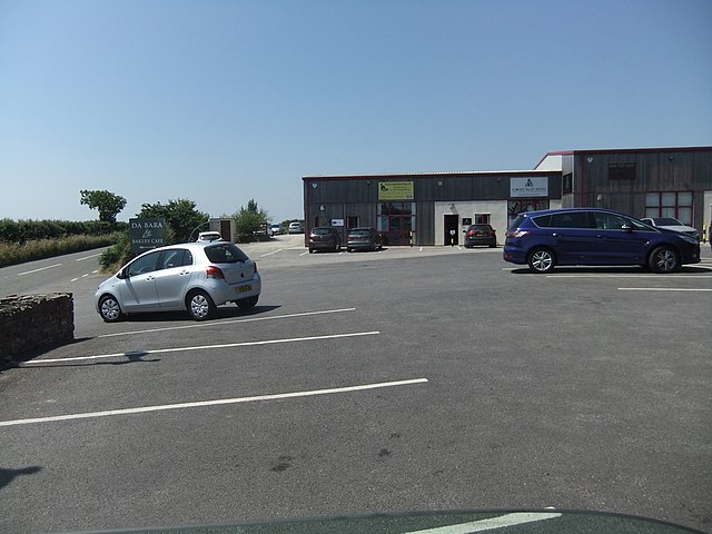
Chenowth's Garage, A3078, Cornwall
Summary
[edit].jpg&action=edit§ion=1)
| Description |
English: Lyn Bryant was seen being followed out of this garage by an unidentified man in a white van on the day she was murdered on 20 October 1998. Her murder remains unsolved |
| Date | |
| Source | https://www.geograph.org.uk/photo/5837788 |
| Author | David Brown |
| Attribution (required by the license) | David Brown / Retail/industrial complex including a bakery / |
| Camera location | | View this and other nearby images on: OpenStreetMap |
|---|
.jpg¶ms=050.241197_N_-004.919262_E_globe:Earth_type:camera_source:geograph-osgb36(SW91944199)_heading:247.00&language=en)
| Object location | | View this and other nearby images on: OpenStreetMap |
|---|
.jpg¶ms=050.240910_N_-004.919950_E_globe:Earth_class:object_type:object_source:geograph-osgb36(SW91894196)_heading:247.00&language=en)
Licensing
[edit].jpg&action=edit§ion=2)

|
This image was taken from the Geograph project collection. See this photograph's page on the Geograph website for the photographer's contact details. The copyright on this image is owned by David Brown and is licensed for reuse under the Creative Commons Attribution-ShareAlike 2.0 license.
|
This file is licensed under the Creative Commons Attribution-Share Alike 2.0 Generic license.
Attribution: David Brown
- You are free:
- to share – to copy, distribute and transmit the work
- to remix – to adapt the work
- Under the following conditions:
- attribution – You must give appropriate credit, provide a link to the license, and indicate if changes were made. You may do so in any reasonable manner, but not in any way that suggests the licensor endorses you or your use.
- share alike – If you remix, transform, or build upon the material, you must distribute your contributions under the same or compatible license as the original.
File history
Click on a date/time to view the file as it appeared at that time.
| Date/Time | Thumbnail | Dimensions | User | Comment | |
|---|---|---|---|---|---|
| current | 16:43, 26 July 2022 | | 1,024 × 768 (126 KB) | BarehamOliver (talk | contribs) | Uploaded a work by David Brown from https://www.geograph.org.uk/photo/5837788 with UploadWizard |
You cannot overwrite this file.
File usage on Commons
There are no pages that use this file.
File usage on other wikis
The following other wikis use this file:
- Usage on en.wikipedia.org
.jpg&oldid=808356807)