File:Chestnut Grove Academy, Balham. Jade Johnson mural.jpg
Jump to navigation
Jump to search

Size of this preview: 800 × 412 pixels. Other resolutions: 320 × 165 pixels | 640 × 329 pixels | 1,351 × 695 pixels.
Original file (1,351 × 695 pixels, file size: 437 KB, MIME type: image/jpeg)
Captions
Captions
Add a one-line explanation of what this file represents
Summary
[edit]
| Description |
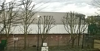
English: The British Olympic long-jumper Jade Johnson attended the Chestnut Grove Academy, and on the side of a sports building are pictures of her in full flight, imitating time-lapse photography.
People not having business in the school can only see this mural from the train; the view is best in winter when the leaves are off the trees, but it is still almost impossible to photograph more than a fleeting glimpse. Edit: since this description was written, a new building has occupied the space between the mural and the railway line, rendering the mural (if it still exists) invisible from outside the school. |
| Date | |
| Source | https://www.geograph.org.uk/photo/4825486 |
| Author | Christopher Hilton |
| Attribution (required by the license) | Christopher Hilton / Chestnut Grove Academy, Balham: Jade Johnson mural / |
| Camera location | | View this and other nearby images on: OpenStreetMap |
|---|
Licensing
[edit]

|
This image was taken from the Geograph project collection. See this photograph's page on the Geograph website for the photographer's contact details. The copyright on this image is owned by Christopher Hilton and is licensed for reuse under the Creative Commons Attribution-ShareAlike 2.0 license.
|
This file is licensed under the Creative Commons Attribution-Share Alike 2.0 Generic license.
Attribution: Christopher Hilton
- You are free:
- to share – to copy, distribute and transmit the work
- to remix – to adapt the work
- Under the following conditions:
- attribution – You must give appropriate credit, provide a link to the license, and indicate if changes were made. You may do so in any reasonable manner, but not in any way that suggests the licensor endorses you or your use.
- share alike – If you remix, transform, or build upon the material, you must distribute your contributions under the same or compatible license as the original.
File history
Click on a date/time to view the file as it appeared at that time.
| Date/Time | Thumbnail | Dimensions | User | Comment | |
|---|---|---|---|---|---|
| current | 22:50, 22 April 2022 | | 1,351 × 695 (437 KB) | ThatRandomGuy1 (talk | contribs) | Uploaded a work by Christopher Hilton from https://www.geograph.org.uk/photo/4825486 with UploadWizard |
You cannot overwrite this file.
File usage on Commons
There are no pages that use this file.
File usage on other wikis
The following other wikis use this file:
- Usage on en.wikipedia.org