File:Chloris divaricata spikelet mature3 - Flickr - Macleay Grass Man.jpg
Jump to navigation
Jump to search

Size of this preview: 800 × 532 pixels. Other resolutions: 320 × 213 pixels | 640 × 425 pixels | 1,024 × 680 pixels | 1,280 × 851 pixels | 2,560 × 1,701 pixels | 4,912 × 3,264 pixels.
Original file (4,912 × 3,264 pixels, file size: 3.84 MB, MIME type: image/jpeg)
Captions
Captions
Add a one-line explanation of what this file represents
Summary
[edit]
| Description |
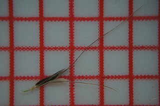
Native warm-season perennial slender hairless C4 grass; tufted or with short stolons; stems are flattened near their base, erect and to 50 cm tall. Flowerheads are digitate, with 3-8 branches, each 7-20 long and widely spreading at maturity. Spikelets are pressed against the stem, pointed and narrowed at the apex, laterally flattened, keeled and 2-flowered; lower fertile lemma is 2-3 mm long and awned; upper lemma is deeply 2-lobed, with an awn arising between the lobes. Flowers from late spring to autumn. Most commonly found on alluvial soils subject to periodic flooding (e.g. road drains, edge of wetlands); rarely abundant and more common in the north of the state. Native biodiversity. Good coloniser of bare ground. After warm-season rain it grows very quickly and provides moderately palatable feed; however, it has low productivity and runs to seed very quickly. Tolerant of grazing and tends to become more abundant under heavy grazing, but rests at flowering aid its persistence. |
| Date | |
| Source | Chloris divaricata spikelet mature3 |
| Author | Harry Rose from Dungog, Australia |
| Camera location | | View this and other nearby images on: OpenStreetMap |
|---|
Licensing
[edit]
This file is licensed under the Creative Commons Attribution 2.0 Generic license.
- You are free:
- to share – to copy, distribute and transmit the work
- to remix – to adapt the work
- Under the following conditions:
- attribution – You must give appropriate credit, provide a link to the license, and indicate if changes were made. You may do so in any reasonable manner, but not in any way that suggests the licensor endorses you or your use.
| This image was originally posted to Flickr by Macleay Grass Man at https://flickr.com/photos/73840284@N04/24751901199. It was reviewed on 5 November 2016 by FlickreviewR and was confirmed to be licensed under the terms of the cc-by-2.0. |
File history
Click on a date/time to view the file as it appeared at that time.
| Date/Time | Thumbnail | Dimensions | User | Comment | |
|---|---|---|---|---|---|
| current | 14:02, 5 November 2016 | | 4,912 × 3,264 (3.84 MB) | Josve05a (talk | contribs) | == {{int:filedesc}} == {{Information |Description=Native warm-season perennial slender hairless C4 grass; tufted or with short stolons; stems are flattened near their base, erect and to 50 cm tall. Flowerheads are digitate, with 3-8 branches, each 7-20... |
You cannot overwrite this file.
File usage on Commons
There are no pages that use this file.