File:Cities of Tierra del Fuego.png
Jump to navigation
Jump to search
No higher resolution available.
Cities_of_Tierra_del_Fuego.png (519 × 475 pixels, file size: 21 KB, MIME type: image/png)
Captions
Captions
Add a one-line explanation of what this file represents
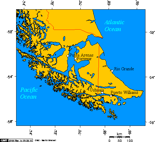
English: Cities of Tierra del Fuego
Esperanto: Urboj de Fuegio
Español: Ciudades de Tierra del Fuego

|
Permission is granted to copy, distribute and/or modify this document under the terms of the GNU Free Documentation License, Version 1.2 or any later version published by the Free Software Foundation; with no Invariant Sections, no Front-Cover Texts, and no Back-Cover Texts. A copy of the license is included in the section entitled GNU Free Documentation License. |
| This file is licensed under the Creative Commons Attribution-Share Alike 3.0 Unported license. | ||
| ||
| This licensing tag was added to this file as part of the GFDL licensing update. |
This map is taken from en:Image:Cities of Tierra del Fuego.png and was created with this online map creation tool archive copy at the Wayback Machine. Uploaded by en:User:Geo Swan on 14 March 2005.
The longitude and latitude of the cities follow:
- -70.9333,-53.1666,Punta Arenas
- -70.3648,-53.2959,Porvenir
- -67.6167,-54.9333,Puerto Williams
- -68.2978,-54.7921,Ushuaia
- -67.5982,-53.8114,Rio Grande
File history
Click on a date/time to view the file as it appeared at that time.
| Date/Time | Thumbnail | Dimensions | User | Comment | |
|---|---|---|---|---|---|
| current | 11:47, 6 October 2005 | | 519 × 475 (21 KB) | ChongDae (talk | contribs) | This image was copied from wikipedia:en. The original description was: Cities of Tierra del Fuego {{GFDL}} This map was created with this [http://www.aquarius.geomar.de/omc/ online map creation tool]. The longitude and latitude of the cities follow: *- |
| 10:46, 24 April 2005 |  | 519 × 475 (21 KB) | Poulpy (talk | contribs) | Cities of Tierra del Fuego {{GFDL}} This map is taken from en:Image:Cities of Tierra del Fuego.png and was created with this [http://www.aquarius.geomar.de/omc/ online map creation tool]. The longitude and latitude of the cities follow: *-70.9333,- |
You cannot overwrite this file.
File usage on Commons
The following 3 pages use this file:
File usage on other wikis
The following other wikis use this file:
- Usage on ar.wikipedia.org
- Usage on bg.wikipedia.org
- Usage on ca.wikipedia.org
- Usage on ckb.wikipedia.org
- Usage on cs.wikipedia.org
- Usage on da.wikipedia.org
- Usage on de.wikipedia.org
- Usage on el.wikipedia.org
- Usage on en.wikipedia.org
- Usage on eo.wikipedia.org
- Usage on es.wikipedia.org
- Usage on fa.wikipedia.org
- Usage on fr.wikipedia.org
- Usage on fy.wikipedia.org
- Usage on gd.wikipedia.org
- Usage on hr.wikipedia.org
- Usage on id.wikipedia.org
- Usage on it.wikipedia.org
- Usage on ja.wikipedia.org
- Usage on ka.wikipedia.org
- Usage on ko.wikipedia.org
- Usage on la.wikipedia.org
- Usage on lt.wikipedia.org
- Usage on mk.wikipedia.org
- Usage on ml.wikipedia.org
- Usage on nl.wikipedia.org
- Usage on no.wikipedia.org
- Usage on pl.wikipedia.org
- Usage on pl.wiktionary.org
- Usage on pt.wikipedia.org
- Usage on ro.wikipedia.org
View more global usage of this file.