File:City of New York - by T and E.H. Ensign. NYPL434693.tiff
Jump to navigation
Jump to search

Size of this JPG preview of this TIF file: 800 × 461 pixels. Other resolutions: 320 × 184 pixels | 640 × 369 pixels | 1,024 × 590 pixels | 1,280 × 738 pixels | 2,560 × 1,476 pixels | 9,554 × 5,508 pixels.
Original file (9,554 × 5,508 pixels, file size: 150.56 MB, MIME type: image/tiff)
Captions
Captions
Add a one-line explanation of what this file represents
Summary
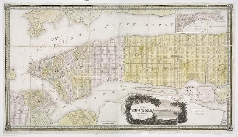
[edit]| Description | City of New York / by T and E.H. Ensign.; Maps of New York City and State / New York City / Manhattan | |||||||||||||||||||||||
| Notes | "Entered according to act of Congress, on the 30th day of March 1845, in the Office of the Clerk of the Southern District of New York by T and E.H. Ensign." ''Note 2.'') Also covers portions of Brooklyn, Williamsburg, Jersey City and, Hoboken. ''Note 3.'') Includes view of the city in cartouche. Also includes census of the city at various periods. ''Note 4.'') Inset: Northern part of New York Island on a reduced scale. ''Note 5.'') National Endowment for the Humanities Grant for Access to Early Maps of the Middle Atlantic Seaboard. ''Note 6.'') Oriented with north to upper right. ''Note 7.'') Relief shown by hachures. ''Note 8.'') Shows ward boundaries and ferry routes. | |||||||||||||||||||||||
| Item physical description | 1 map on 2 sheets : hand col. ; 58 x 112 cm., sheets 66 x 58 cm. | |||||||||||||||||||||||
| Catalogue call number | Map Div. 01-1803 | |||||||||||||||||||||||
| Standard reference | Haskell, D.C. Manhattan maps, 882 | |||||||||||||||||||||||
| Date | ||||||||||||||||||||||||
| Source |
http://digitalgallery.nypl.org/nypldigital/dgkeysearchdetail.cfm?imageID=434693
|
|||||||||||||||||||||||
| Author | T. and E. H. Ensign -- Publisher | |||||||||||||||||||||||
| Permission (Reusing this file) |
From The Lionel Pincus and Princess Firyal Map Division. http://maps.nypl.org
|
|||||||||||||||||||||||
| Location | Stephen A. Schwarzman Building / The Lionel Pincus and Princess Firyal Map Division | |||||||||||||||||||||||
| Digital item published | 2-3-2004; updated 5-16-2012 | |||||||||||||||||||||||
| Digital ID | 434693 | |||||||||||||||||||||||

The making of this file was supported by Wikimedia UK.
To see other files made with the support of Wikimedia UK, please see the category Supported by Wikimedia UK.
|
File history
Click on a date/time to view the file as it appeared at that time.
| Date/Time | Thumbnail | Dimensions | User | Comment | |
|---|---|---|---|---|---|
| current | 23:05, 26 April 2014 |  | 9,554 × 5,508 (150.56 MB) | Fæ (talk | contribs) | GWToolset:: Creating mediafile for Fæ. Tranche 3 5495-7474 |
You cannot overwrite this file.
File usage on Commons
There are no pages that use this file.