File:Clarbeston Road 1st railway station (site), Pembrokeshire (geograph 6819716).jpg
Jump to navigation
Jump to search

Size of this preview: 800 × 600 pixels. Other resolutions: 320 × 240 pixels | 640 × 480 pixels | 1,024 × 768 pixels | 1,280 × 960 pixels | 1,600 × 1,200 pixels.
Original file (1,600 × 1,200 pixels, file size: 685 KB, MIME type: image/jpeg)
Captions
Captions
Add a one-line explanation of what this file represents
Summary
[edit],_Pembrokeshire_(geograph_6819716).jpg&action=edit§ion=1)
| Description |
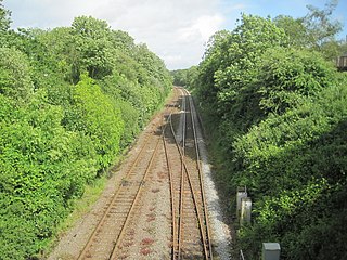
English: Clarbeston Road 1st railway station (site), Pembrokeshire Opened in 1854 by the South Wales Railway on its line from Carmarthen to Neyland, this station lost its wooden booking office in a fire in 1907. In 1914 it is believed to have closed and replaced by a new station immediately behind the camera position (see SN0120 : Clarbeston Road railway station, Pembrokeshire), although some OS maps were showing it at this location until 1963. View south east towards Clunderwen and Carmarthen. |
| Date | |
| Source | From geograph.org.uk |
| Author | Nigel Thompson |
| Permission (Reusing this file) |
Creative Commons Attribution Share-alike license 2.0 |
| Attribution (required by the license) | Nigel Thompson / Clarbeston Road 1st railway station (site), Pembrokeshire / |
.jpg)
| Camera location | | View this and other nearby images on: OpenStreetMap |
|---|
,_Pembrokeshire_(geograph_6819716).jpg¶ms=051.851447_N_-004.881355_E_globe:Earth_type:camera_source:geograph-osgb36(SN01652091)_heading:112.00&language=en)
| Object location | | View this and other nearby images on: OpenStreetMap |
|---|
,_Pembrokeshire_(geograph_6819716).jpg¶ms=051.851200_N_-004.880320_E_globe:Earth_class:object_type:object_source:geograph-osgb36(SN01722088)_heading:112.00&language=en)
Licensing
[edit],_Pembrokeshire_(geograph_6819716).jpg&action=edit§ion=2)

|
This image was taken from the Geograph project collection. See this photograph's page on the Geograph website for the photographer's contact details. The copyright on this image is owned by Nigel Thompson and is licensed for reuse under the Creative Commons Attribution-ShareAlike 2.0 license.
|
This file is licensed under the Creative Commons Attribution-Share Alike 2.0 Generic license.
Attribution: Nigel Thompson
- You are free:
- to share – to copy, distribute and transmit the work
- to remix – to adapt the work
- Under the following conditions:
- attribution – You must give appropriate credit, provide a link to the license, and indicate if changes were made. You may do so in any reasonable manner, but not in any way that suggests the licensor endorses you or your use.
- share alike – If you remix, transform, or build upon the material, you must distribute your contributions under the same or compatible license as the original.
File history
Click on a date/time to view the file as it appeared at that time.
| Date/Time | Thumbnail | Dimensions | User | Comment | |
|---|---|---|---|---|---|
| current | 15:33, 16 November 2021 | | 1,600 × 1,200 (685 KB) | Lamberhurst (talk | contribs) | == {{int:filedesc}} == {{Information |Description={{en|1=<b>Clarbeston Road 1st railway station (site), Pembrokeshire</b><br>Opened in 1854 by the South Wales Railway on its line from Carmarthen to Neyland, this station lost its wooden booking office in a fire in 1907. In 1914 it is believed to have closed and replaced by a new station immediately behind the camera position (see [[:File:Clarbeston Road railway station, Pembrokeshire (geograph 5421673).jpg|SN0120 : Clarbeston Road railway stat... |
You cannot overwrite this file.
File usage on Commons
The following page uses this file:
,_Pembrokeshire_(geograph_6819716).jpg&oldid=861679517)