File:Commissione Italo-Britannica per la Delimitazione del Confine Somalo. Graticule verification diagrams (WOMAT-ADD-87-1-2-1-7).jpg

Original file (4,928 × 6,605 pixels, file size: 15.97 MB, MIME type: image/jpeg)
Captions
Captions
Summary[edit]
| Title |
Commissione Italo-Britannica per la Delimitazione del Confine Somalo'. Graticule verification diagrams |
|||
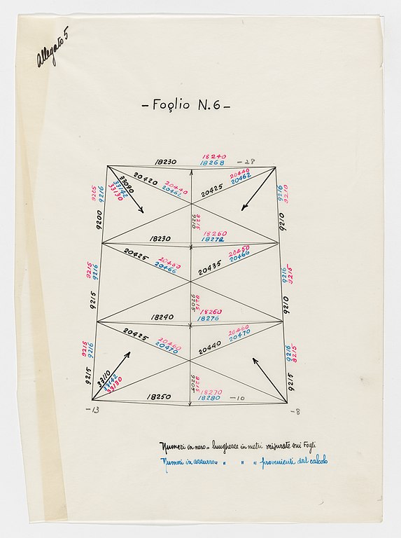
| Description |
Diagrams comparing graticule lengths determined by calculation to those determined by measurement on the map sheets. Includes table of temperature and humidity during field survey. An English translation is at WOMAT/ADD/87/1/2/2. |
|||
| British Library Shelfmark | WOMAT/ADD/87/1/2/1/7 | |||
| Locations Depicted | British Somaliland, Africa, 1884-1960 Italian Somaliland, Africa, 1889-1936 | |||
| Centre Point Coordinates | ||||
| Date | between 1929 and 1930 | |||
| Source |
|
|||
| Creator |
Anglo-Italian Somaliland Boundary Commission, 1929-1930, Publisher Borra, -, fl 1929-1930, army officer, Surveyor Cabitto, -, fl 1929-1930, army officer, Surveyor Cerulli, Enrico, 1898-1988, government and colonial administrator, Author Mosconi, -, fl 1929-1930, government and colonial administrator, Author |
|||
| Permission (Reusing this file) |
|
|||
| Geotemporal data | ||||
| Map location |
British Somaliland Italian Somaliland |
|||
| Georeferencing | If inappropriate please set warp_status = skip to hide. | |||
| Archival data | ||||
| Collection | ||||
| Dimensions | 56 x 77cm | |||
| Medium | Manuscript: coloured ink, pencil and crayon on tracing paper | |||
| Notes | For more information please see the British Library’s Collection Guide to the War Office Archive. Archived from the original on 2016-01-11. Retrieved on 2018-03-28. | |||


.jpg&action=edit§ion=1)
File history
Click on a date/time to view the file as it appeared at that time.
| Date/Time | Thumbnail | Dimensions | User | Comment | |
|---|---|---|---|---|---|
| current | 11:15, 28 March 2018 | | 4,928 × 6,605 (15.97 MB) | Ndalyrose (talk | contribs) | GWToolset: Creating mediafile for Ndalyrose. |
You cannot overwrite this file.
File usage on Commons
There are no pages that use this file.
.jpg&oldid=866556789)