File:Connemara Marble Slabs (geograph 4005264).jpg
Jump to navigation
Jump to search

Size of this preview: 800 × 484 pixels. Other resolutions: 320 × 194 pixels | 640 × 387 pixels | 1,024 × 620 pixels | 1,280 × 774 pixels | 2,271 × 1,374 pixels.
Original file (2,271 × 1,374 pixels, file size: 3.01 MB, MIME type: image/jpeg)
Captions
Captions
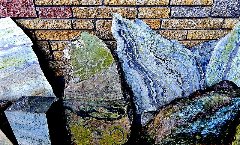
Slabs of Connemara marble
Summary
[edit].jpg&action=edit§ion=1)
| Description |
English: View is to the southwest. These slabs are on display outside near the entrance. In the past, much larger slabs were quarried, cut & polished for use as flooring and window sills in abbeys, churches, cathedrals, friaries & monasteries primarily. Today, only small pieces of Connemara Marble are sold, as the supply is starting to dwindle. |
| Date | |
| Source | https://www.geograph.ie/photo/4005264 |
| Author | Suzanne Mischyshyn |
| Attribution (required by the license) | Suzanne Mischyshyn / County Galway Moycullen- Connemara Marble - Connemara Marble Slabs / |
| Camera location | | View this and other nearby images on: OpenStreetMap |
|---|
.jpg¶ms=053.340513_N_-009.184665_E_globe:Earth_type:camera_heading:247.00&language=en)
Licensing
[edit].jpg&action=edit§ion=2)

|
This image was taken from the Geograph project collection. See this photograph's page on the Geograph website for the photographer's contact details. The copyright on this image is owned by Suzanne Mischyshyn and is licensed for reuse under the Creative Commons Attribution-ShareAlike 2.0 license.
|
This file is licensed under the Creative Commons Attribution-Share Alike 2.0 Generic license.
Attribution: Suzanne Mischyshyn
- You are free:
- to share – to copy, distribute and transmit the work
- to remix – to adapt the work
- Under the following conditions:
- attribution – You must give appropriate credit, provide a link to the license, and indicate if changes were made. You may do so in any reasonable manner, but not in any way that suggests the licensor endorses you or your use.
- share alike – If you remix, transform, or build upon the material, you must distribute your contributions under the same or compatible license as the original.
File history
Click on a date/time to view the file as it appeared at that time.
| Date/Time | Thumbnail | Dimensions | User | Comment | |
|---|---|---|---|---|---|
| current | 12:15, 4 June 2020 | | 2,271 × 1,374 (3.01 MB) | Bjh21 (talk | contribs) | Higher-resolution version from Geograph |
| 14:51, 16 May 2020 |  | 1,024 × 620 (366 KB) | Licks-rocks (talk | contribs) | Uploaded a work by Suzanne Mischyshyn from https://www.geograph.ie/photo/4005264 with UploadWizard |
You cannot overwrite this file.
File usage on Commons
The following 2 pages use this file:
- File:4005264 3830cff3 1024x1024.jpg (file redirect)
- Category:Connemara marble
File usage on other wikis
The following other wikis use this file:
- Usage on en.wikipedia.org
- Usage on no.wikipedia.org
- Usage on www.wikidata.org
.jpg&oldid=867522027)