File:Contextual view from hospital historic district showing top of building 680; camera facing northeast. - Mare Island Naval Shipyard, Machine Shop, California Avenue, southwest HABS CAL,48-MARI,1BT-1.tif
Jump to navigation
Jump to search

Size of this JPG preview of this TIF file: 739 × 600 pixels. Other resolutions: 296 × 240 pixels | 592 × 480 pixels | 947 × 768 pixels | 1,262 × 1,024 pixels | 2,524 × 2,048 pixels | 5,000 × 4,057 pixels.
Original file (5,000 × 4,057 pixels, file size: 19.35 MB, MIME type: image/tiff)
Captions
Captions
Add a one-line explanation of what this file represents
Summary[edit]
| Photographer |
Dewey, William |
|||
| Title |
Contextual view from hospital historic district showing top of building 680; camera facing northeast. - Mare Island Naval Shipyard, Machine Shop, California Avenue, southwest corner of California Avenue and Thirteenth Street, Vallejo, Solano County, CA |
|||
| Depicted place | California; Solano County; Vallejo | |||
| Date | 1998 | |||
| Dimensions | 4 x 5 in. | |||
| Current location |
Library of Congress Prints and Photographs Division Washington, D.C. 20540 USA http://hdl.loc.gov/loc.pnp/pp.print |
|||
| Accession number |
HABS CAL,48-MARI,1BT-1 |
|||
| Credit line |
|
|||
| Notes |
|
|||
| References |
|
|||
| Source | https://www.loc.gov/pictures/item/ca2512.photos.326147p | |||
| Permission (Reusing this file) |
|

| Object location | | View this and other nearby images on: OpenStreetMap |
|---|
File history
Click on a date/time to view the file as it appeared at that time.
| Date/Time | Thumbnail | Dimensions | User | Comment | |
|---|---|---|---|---|---|
| current | 02:42, 7 July 2014 | 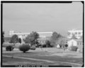 | 5,000 × 4,057 (19.35 MB) | Fæ (talk | contribs) | GWToolset: Creating mediafile for Fæ. HABS 05 July 2014 (401:500) |
You cannot overwrite this file.
File usage on Commons
The following page uses this file: