File:Coolfont Manor House, near Berkeley Springs in Morgan County, West Virginia LCCN2015631471.tif
Jump to navigation
Jump to search
Size of this JPG preview of this TIF file: 400 × 599 pixels. Other resolutions: 160 × 240 pixels | 320 × 480 pixels | 512 × 768 pixels | 683 × 1,024 pixels | 1,367 × 2,048 pixels | 4,912 × 7,360 pixels.
Original file (4,912 × 7,360 pixels, file size: 206.96 MB, MIME type: image/tiff)
Captions
Captions
Add a one-line explanation of what this file represents
Summary[edit]
| Description |
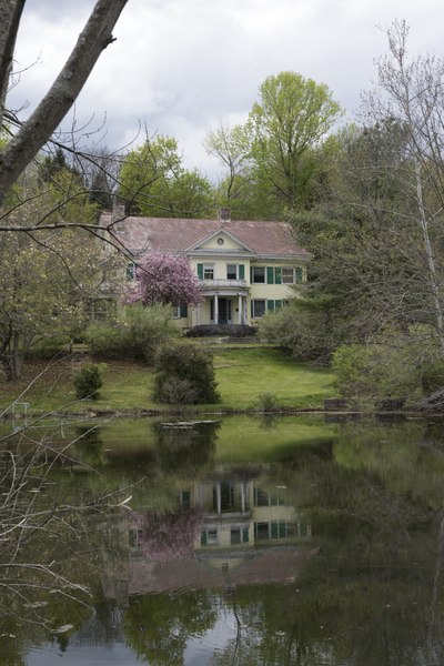
English: Title: Coolfont Manor House, near Berkeley Springs in Morgan County, West Virginia
Physical description: 1 photograph : digital, tiff file, color. Notes: The house is the central point of a rustic resort. In 1756, a British veteran of General Edward Braddock's defeat during the French and Indian War built a cabin near cool springs in the Sir John's Run Valley along the eastern slope of Cacapon Mountain. More than 150 years later, prolific author, ecologist and presidential appointee Herbert Quick chose the same site to live out his "back-to-the-farm" philosophy. In 1910, Quick built the stately manor house, pond and several outbuildings as the centerpiece of his experimental farm. He called it Coolfont in honor of the springs. The surrounding Coolfont Resort was created by Sam Ashelman and Rol and Alden Capen in 1965. Among its miles of mountain hiking trails is the Green Trail to historic Prospect Rock where George Washington often rode.; Credit line: West Virginia Collection within the Carol M. Highsmith Archive, Library of Congress, Prints and Photographs Division.; Forms part of: West Virginia Collection within the Carol M. Highsmith Archive.; Title, date and keywords based on information provided by the photographer.; Purchase; Carol M. Highsmith Photography, Inc.; 2015; (DLC/PP-2015:055). |
||||||||||||||||||||||||||
| Date | Taken on 30 April 2015, 13:49 (according to Exif data) | ||||||||||||||||||||||||||
| Source |
Library of Congress
|
||||||||||||||||||||||||||
| Author |
|
||||||||||||||||||||||||||
| Permission (Reusing this file) |
No known restrictions on publication.
|
||||||||||||||||||||||||||


| Camera location | | View this and other nearby images on: OpenStreetMap |
|---|
Licensing[edit]
| This work is from the Carol M. Highsmith Archive collection at the Library of Congress. According to the library, there are no known copyright restrictions on the use of this work. Carol M. Highsmith has stipulated that her photographs are in the public domain. Photographs of sculpture or other works of art may be restricted by the copyright of the artist. |
 |
File history
Click on a date/time to view the file as it appeared at that time.
| Date/Time | Thumbnail | Dimensions | User | Comment | |
|---|---|---|---|---|---|
| current | 07:51, 11 September 2016 |  | 4,912 × 7,360 (206.96 MB) | Fæ (talk | contribs) | LOC 2015631471, Carol M. Highsmith collection. P164.13554 TIFF (207.0mb) |
| 07:51, 11 September 2016 |  | 4,912 × 7,360 (206.96 MB) | Fæ (talk | contribs) | LOC 2015631471, Carol M. Highsmith collection. P164.13554 TIFF (207.0mb) |
You cannot overwrite this file.
File usage on Commons
There are no pages that use this file.