File:Corfu topographic map-en.svg
ナビゲーションに移動
検索に移動

この SVG ファイルのこの PNG プレビューのサイズ: 537 × 600 ピクセル. その他の解像度: 215 × 240 ピクセル | 430 × 480 ピクセル | 688 × 768 ピクセル | 917 × 1,024 ピクセル | 1,834 × 2,048 ピクセル | 2,096 × 2,341 ピクセル。
元のファイル (SVG ファイル、2,096 × 2,341 ピクセル、ファイルサイズ: 2.19メガバイト)
キャプション
キャプション
このファイルの内容を1行で記述してください
![]()
Detailed map of large dimension. For a better viewing, click on the link of the image above.
Carte détaillée de grande dimension. Pour une visualisation optimale, cliquer sur le lien de l'image ci-dessus.
概要[編集]
| 記述 |
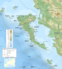
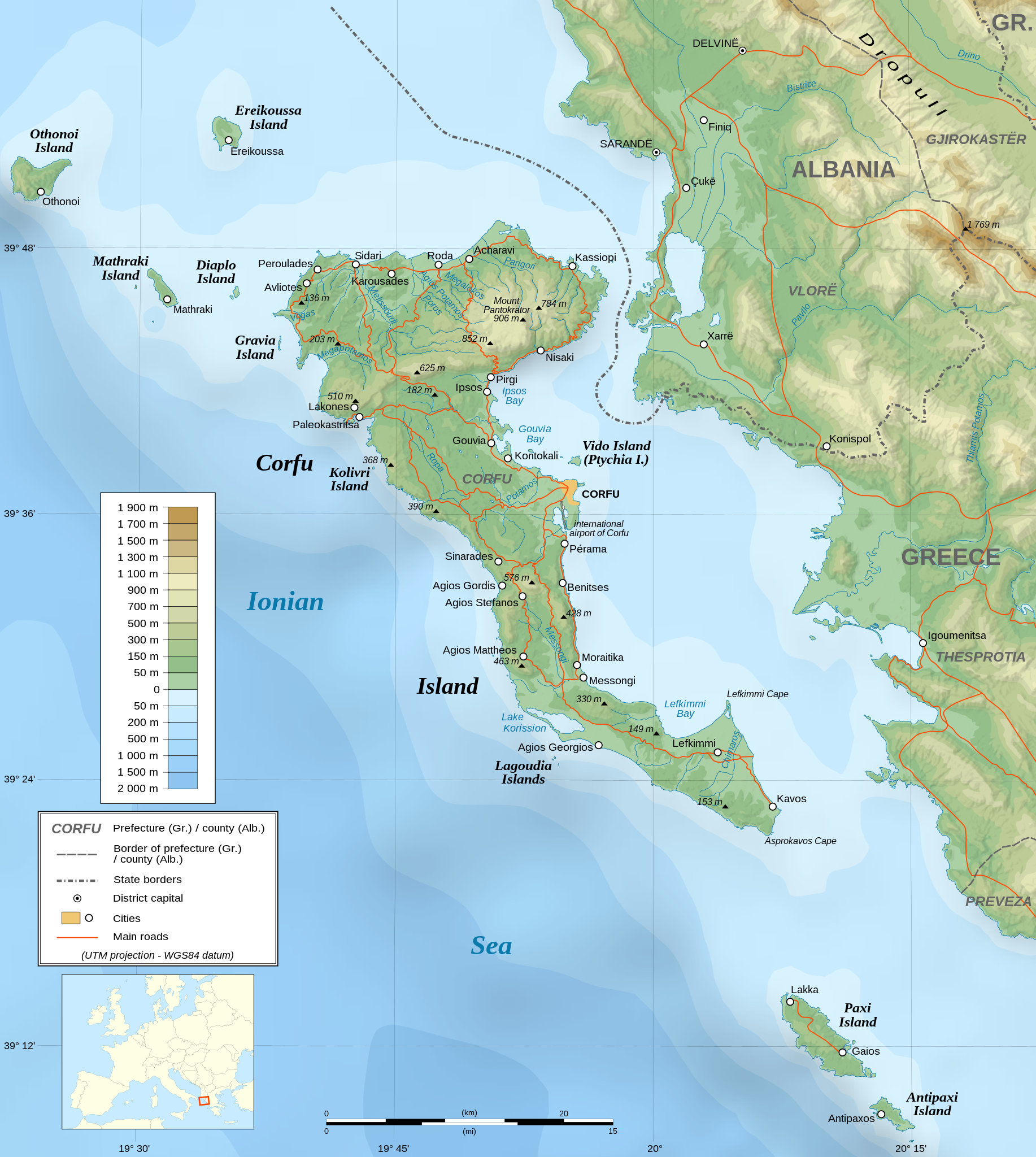
English: Topographic map in English of the Corfu island area in Greece.
Note : The shaded relief is a raster image embedded in the SVG file. Français : Carte topographique en anglais de la zone de l'île de Corfou en Grèce.
Note : Le relief ombré est une image bitmap embarquée dans le fichier SVG. UTM projection ; WGS84 datum ; shaded relief (composite image of N-W, W and N lightning positions) ;
|
||
| SVG 開発 | このSVG地図は埋込み文を用いており,テキストエディタを用いて容易に翻訳することができますいます。 |
||
| 日付 | March 2007 (modified 09/2008) | ||
| 原典 |
Own work ;
|
||
| 作者 | |||
| 許可 (ファイルの再利用) |
|
||
| Georeferencing | If inappropriate please set warp_status = skip to hide. | ||
| その他のバージョン |
[]
|


ライセンス[編集]
この作品の著作権者である私は、この作品を以下のライセンスで提供します。

|
この文書は、フリーソフトウェア財団発行のGNUフリー文書利用許諾書 (GNU Free Documentation License) 1.2またはそれ以降のバージョンの規約に基づき、複製や再配布、改変が許可されます。不可変更部分、表紙、背表紙はありません。このライセンスの複製は、GNUフリー文書利用許諾書という章に含まれています。 |
| このファイルはクリエイティブ・コモンズ 表示-継承 3.0 非移植ライセンスのもとに利用を許諾されています。 | ||
| ||
| このライセンスのテンプレートは、GFDLのライセンス・アップデートによりこのファイルに追加されたものです。 |
- あなたは以下の条件に従う場合に限り、自由に
- 共有 – 本作品を複製、頒布、展示、実演できます。
- 再構成 – 二次的著作物を作成できます。
- あなたの従うべき条件は以下の通りです。
- 表示 – あなたは適切なクレジットを表示し、ライセンスへのリンクを提供し、変更があったらその旨を示さなければなりません。これらは合理的であればどのような方法で行っても構いませんが、許諾者があなたやあなたの利用行為を支持していると示唆するような方法は除きます。
- 継承 – もしあなたがこの作品をリミックスしたり、改変したり、加工した場合には、あなたはあなたの貢献部分を元の作品とこれと同一または互換性があるライセンスの下に頒布しなければなりません。
あなたは上記のライセンスから、どれか一つ以上を選択できます。
評価[編集]

ファイルの履歴
過去の版のファイルを表示するには、その版の日時をクリックしてください。
| 日付と時刻 | サムネイル | 寸法 | 利用者 | コメント | |
|---|---|---|---|---|---|
| 現在の版 | 2021年8月24日 (火) 07:17 | | 2,096 × 2,341 (2.19メガバイト) | Praça de Maio (トーク | 投稿記録) | File uploaded using svgtranslate tool (https://svgtranslate.toolforge.org/). Added translation for tr. |
| 2014年10月29日 (水) 22:47 |  | 2,096 × 2,341 (2.18メガバイト) | Ras67 (トーク | 投稿記録) | cropped | |
| 2008年9月4日 (木) 22:41 |  | 2,100 × 2,345 (2.47メガバイト) | Sting (トーク | 投稿記録) | Using bathymetry from ETOPO1 ; new standard colors | |
| 2007年10月29日 (月) 18:59 |  | 2,100 × 2,345 (3.17メガバイト) | Sting (トーク | 投稿記録) | "Pavllo" river name correction ; + river names on Corfu island ; key more complete | |
| 2007年5月16日 (水) 01:05 |  | 2,100 × 2,345 (3.14メガバイト) | Sting (トーク | 投稿記録) | International elevation key | |
| 2007年3月30日 (金) 01:07 |  | 2,100 × 2,345 (3.14メガバイト) | Sting (トーク | 投稿記録) | {{Information| |Description=Topographic map in French of the Corfu island area in Greece. |Source=Own work ;<br/>Background map : [http://www2.jpl.nasa.gov/srtm NASA Shuttle Radar Topography Mission] (SRTM3 v.2) (public domain) edited with [ |
このファイルは上書きできません。
ファイルの使用状況
以下の 57 ページがこのファイルを使用しています:
- Wikimedia Conference Japan 2009/Commons写真展
- User:Aristeas/check
- User:Giorgi Balakhadze/Gallery
- User:JoKalliauer/SVG test suites/Featured details
- User:Magog the Ogre/Multilingual legend/2021 August 21-31
- User:Miya/Introduction
- User:Pfctdayelise/POTY07 categories/2007 list
- User:SVGbot/Results
- User:Sting/Gallery: Regional maps
- User:Sting/Profile
- User talk:MapMaster
- User talk:Sting/Archive 01
- Commons:Bu proje sayfasının diğer dil sürümleri
- Commons:Conhece os nossos ilustradores
- Commons:Conoce a nuestros ilustradores
- Commons:Descobreix els nostres il.lustradors
- Commons:Descobrètz nòstres illustrators
- Commons:Découvrez nos illustrateurs
- Commons:Featured picture candidates/Image:Corfu topographic map-en.svg
- Commons:Featured picture candidates/Log/November 2007
- Commons:Featured pictures/Non-photographic media/Maps
- Commons:Featured pictures/chronological/2007-B
- Commons:Graphic Lab/Map workshop/Archive/2014
- Commons:Meet our illustrators
- Commons:Meet our illustrators/People
- Commons:Picture of the Year/2007/Galleries/All
- Commons:Picture of the Year/2007/Galleries/Graphic art and maps
- Commons:Picture of the Year/2007/Results/Round 1/Gallery
- Commons:Poznaj naszych grafików
- Commons:Scopri i nostri illustratori
- Commons:Scummigghia ê nostri llustratura
- Commons:Unsere Illustratoren stellen sich vor
- Commons:Unseri Illustratore stelle sich vor
- Commons:Upoznajte naše ilustratore
- Commons:Çizerlerimizle tanışın
- Commons:Запознајте ги нашите илустратори
- Commons:Знайомтесь з нашими ілюстраторами
- Commons:Знакомьтесь с нашими иллюстраторами
- Commons:قابل رسامينا
- Commons:私達のイラストレータをご紹介します
- Commons:结识我们的插图师
- Commons:우리들의 삽화가를 만나보세요
- Commons talk:Project Mapmaking Wiki Standards/Archive01
- File:Corfu topographic map-Stad.PNG
- File:Corfu topographic map-be.svg
- File:Corfu topographic map-blank.svg
- File:Corfu topographic map-de.svg
- File:Corfu topographic map-el.svg
- File:Corfu topographic map-en.svg
- File:Corfu topographic map-en librsvg.png
- File:Corfu topographic map-en rendersvg.png
- File:Corfu topographic map-es.svg
- File:Corfu topographic map-fr.svg
- File:Corfu topographic map-hu.svg
- File:Corfu topographic map-mk.svg
- File:Corfu topographic map-nb.svg
- Template:Other versions/Corfu topographic map
グローバルなファイル使用状況
以下に挙げる他のウィキがこの画像を使っています:
- af.wikipedia.org での使用状況
- bg.wikipedia.org での使用状況
- bn.wikipedia.org での使用状況
- bs.wikipedia.org での使用状況
- ca.wikipedia.org での使用状況
- de.wikipedia.org での使用状況
- en.wikipedia.org での使用状況
- es.wikipedia.org での使用状況
- fa.wikipedia.org での使用状況
- fi.wikipedia.org での使用状況
- fr.wikipedia.org での使用状況
- fy.wikipedia.org での使用状況
- gl.wikipedia.org での使用状況
- he.wikipedia.org での使用状況
- hu.wikipedia.org での使用状況
- hy.wikipedia.org での使用状況
- ia.wikipedia.org での使用状況
- id.wikipedia.org での使用状況
- is.wikipedia.org での使用状況
- it.wikipedia.org での使用状況
- it.wikivoyage.org での使用状況
- ja.wikipedia.org での使用状況
このファイルのグローバル使用状況を表示する。