File:Corfu topographic map-en.svg
跳转到导航
跳转到搜索

此SVG文件的PNG预览的大小:537 × 600像素。 其他分辨率:215 × 240像素 | 430 × 480像素 | 688 × 768像素 | 917 × 1,024像素 | 1,834 × 2,048像素 | 2,096 × 2,341像素。
原始文件 (SVG文件,尺寸为2,096 × 2,341像素,文件大小:2.19 MB)
说明
说明
添加一行文字以描述该文件所表现的内容
![]()
Detailed map of large dimension. For a better viewing, click on the link of the image above.
Carte détaillée de grande dimension. Pour une visualisation optimale, cliquer sur le lien de l'image ci-dessus.
摘要
[编辑]| 描写 |
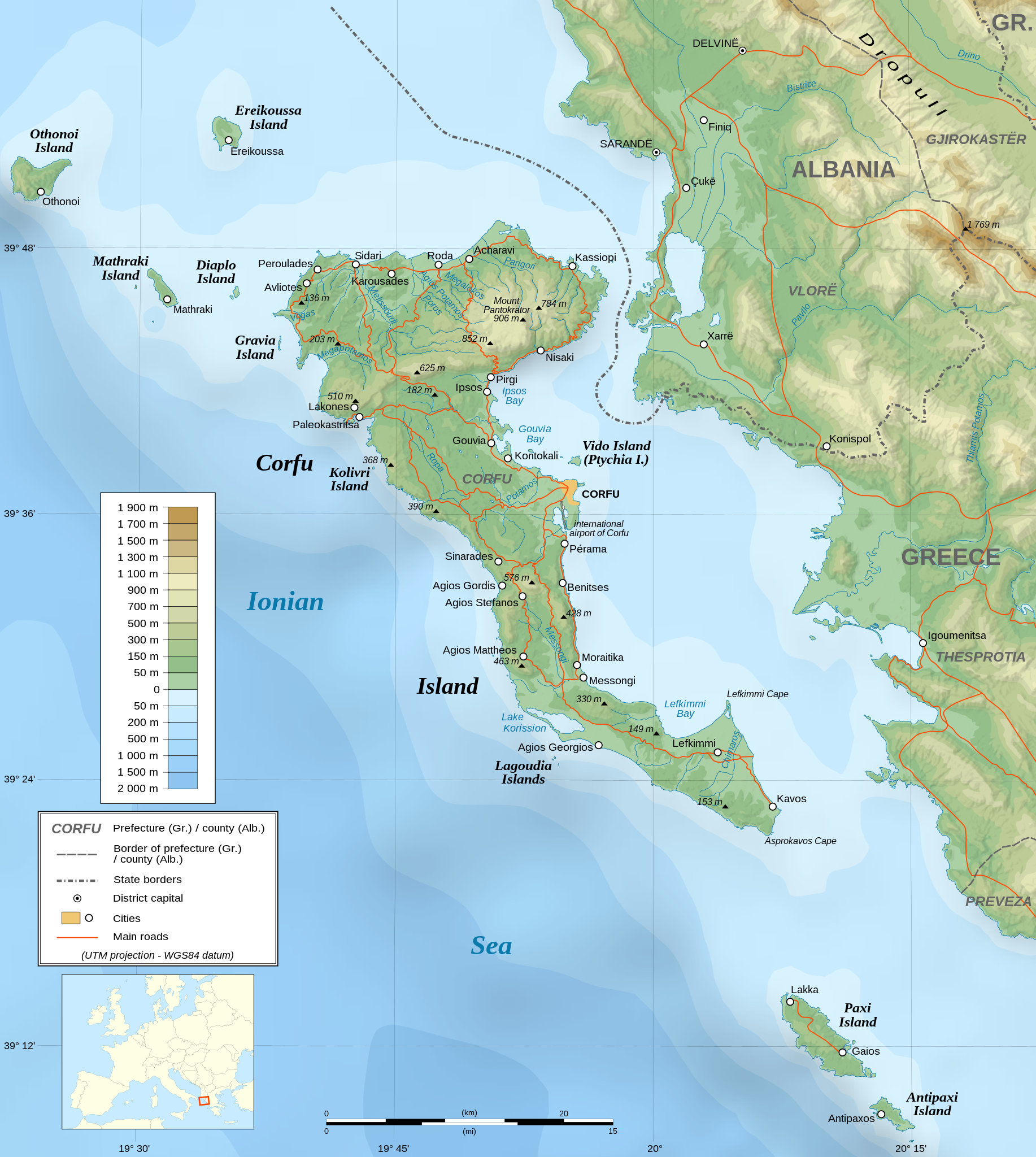
English: Topographic map in English of the Corfu island area in Greece.
Note : The shaded relief is a raster image embedded in the SVG file. Français : Carte topographique en anglais de la zone de l'île de Corfou en Grèce.
Note : Le relief ombré est une image bitmap embarquée dans le fichier SVG. UTM projection ; WGS84 datum ; shaded relief (composite image of N-W, W and N lightning positions) ;
|
||
| SVG开发 | 此SVG 文件使用了内嵌文本,可以使用任何文本编辑器轻松翻译。 |
||
| 日期 | March 2007 (modified 09/2008) | ||
| 来源 |
Own work ;
|
||
| 创作作者 | |||
| 授权 (二次使用本文件) |
|
||
| 地理参考 | 如果不适当,请设置 warp_status = skip 为隐藏。 | ||
| 其他版本 |
[]
|


许可协议
[编辑]我,本作品著作权人,特此采用以下许可协议发表本作品:

|
已授权您依据自由软件基金会发行的无固定段落及封面封底文字(Invariant Sections, Front-Cover Texts, and Back-Cover Texts)的GNU自由文件许可协议1.2版或任意后续版本的条款,复制、传播和/或修改本文件。该协议的副本请见“GNU Free Documentation License”。 |
| 本文件采用知识共享署名-相同方式共享 3.0 未本地化版本许可协议授权。 | ||
| ||
| 本许可协议标签作为GFDL许可协议更新的组成部分被添加至本文件。 |
- 您可以自由地:
- 共享 – 复制、发行并传播本作品
- 修改 – 改编作品
- 惟须遵守下列条件:
- 署名 – 您必须对作品进行署名,提供授权条款的链接,并说明是否对原始内容进行了更改。您可以用任何合理的方式来署名,但不得以任何方式表明许可人认可您或您的使用。
- 相同方式共享 – 如果您再混合、转换或者基于本作品进行创作,您必须以与原先许可协议相同或相兼容的许可协议分发您贡献的作品。
您可以选择您需要的许可协议。
评价
[编辑]
文件历史
点击某个日期/时间查看对应时刻的文件。
| 日期/时间 | 缩略图 | 大小 | 用户 | 备注 | |
|---|---|---|---|---|---|
| 当前 | 2021年8月24日 (二) 07:17 | | 2,096 × 2,341(2.19 MB) | Praça de Maio(留言 | 贡献) | File uploaded using svgtranslate tool (https://svgtranslate.toolforge.org/). Added translation for tr. |
| 2014年10月29日 (三) 22:47 |  | 2,096 × 2,341(2.18 MB) | Ras67(留言 | 贡献) | cropped | |
| 2008年9月4日 (四) 22:41 |  | 2,100 × 2,345(2.47 MB) | Sting(留言 | 贡献) | Using bathymetry from ETOPO1 ; new standard colors | |
| 2007年10月29日 (一) 18:59 |  | 2,100 × 2,345(3.17 MB) | Sting(留言 | 贡献) | "Pavllo" river name correction ; + river names on Corfu island ; key more complete | |
| 2007年5月16日 (三) 01:05 |  | 2,100 × 2,345(3.14 MB) | Sting(留言 | 贡献) | International elevation key | |
| 2007年3月30日 (五) 01:07 |  | 2,100 × 2,345(3.14 MB) | Sting(留言 | 贡献) | {{Information| |Description=Topographic map in French of the Corfu island area in Greece. |Source=Own work ;<br/>Background map : [http://www2.jpl.nasa.gov/srtm NASA Shuttle Radar Topography Mission] (SRTM3 v.2) (public domain) edited with [ |
您不可以覆盖此文件。
文件用途
以下57个页面使用本文件:
- Wikimedia Conference Japan 2009/Commons写真展
- User:Aristeas/check
- User:Giorgi Balakhadze/Gallery
- User:JoKalliauer/SVG test suites/Featured details
- User:Magog the Ogre/Multilingual legend/2021 August 21-31
- User:Miya/Introduction
- User:Pfctdayelise/POTY07 categories/2007 list
- User:SVGbot/Results
- User:Sting/Gallery: Regional maps
- User:Sting/Profile
- User talk:MapMaster
- User talk:Sting/Archive 01
- Commons:Bu proje sayfasının diğer dil sürümleri
- Commons:Conhece os nossos ilustradores
- Commons:Conoce a nuestros ilustradores
- Commons:Descobreix els nostres il.lustradors
- Commons:Descobrètz nòstres illustrators
- Commons:Découvrez nos illustrateurs
- Commons:Featured picture candidates/Image:Corfu topographic map-en.svg
- Commons:Featured picture candidates/Log/November 2007
- Commons:Featured pictures/Non-photographic media/Maps
- Commons:Featured pictures/chronological/2007-B
- Commons:Graphic Lab/Map workshop/Archive/2014
- Commons:Meet our illustrators
- Commons:Meet our illustrators/People
- Commons:Picture of the Year/2007/Galleries/All
- Commons:Picture of the Year/2007/Galleries/Graphic art and maps
- Commons:Picture of the Year/2007/Results/Round 1/Gallery
- Commons:Poznaj naszych grafików
- Commons:Scopri i nostri illustratori
- Commons:Scummigghia ê nostri llustratura
- Commons:Unsere Illustratoren stellen sich vor
- Commons:Unseri Illustratore stelle sich vor
- Commons:Upoznajte naše ilustratore
- Commons:Çizerlerimizle tanışın
- Commons:Запознајте ги нашите илустратори
- Commons:Знайомтесь з нашими ілюстраторами
- Commons:Знакомьтесь с нашими иллюстраторами
- Commons:قابل رسامينا
- Commons:私達のイラストレータをご紹介します
- Commons:结识我们的插图师
- Commons:우리들의 삽화가를 만나보세요
- Commons talk:Project Mapmaking Wiki Standards/Archive01
- File:Corfu topographic map-Stad.PNG
- File:Corfu topographic map-be.svg
- File:Corfu topographic map-blank.svg
- File:Corfu topographic map-de.svg
- File:Corfu topographic map-el.svg
- File:Corfu topographic map-en.svg
- File:Corfu topographic map-en librsvg.png
- File:Corfu topographic map-en rendersvg.png
- File:Corfu topographic map-es.svg
- File:Corfu topographic map-fr.svg
- File:Corfu topographic map-hu.svg
- File:Corfu topographic map-mk.svg
- File:Corfu topographic map-nb.svg
- Template:Other versions/Corfu topographic map
全域文件用途
以下其他wiki使用此文件:
- af.wikipedia.org上的用途
- bg.wikipedia.org上的用途
- bn.wikipedia.org上的用途
- bs.wikipedia.org上的用途
- ca.wikipedia.org上的用途
- de.wikipedia.org上的用途
- en.wikipedia.org上的用途
- es.wikipedia.org上的用途
- fa.wikipedia.org上的用途
- fi.wikipedia.org上的用途
- fr.wikipedia.org上的用途
- fy.wikipedia.org上的用途
- gl.wikipedia.org上的用途
- he.wikipedia.org上的用途
- hu.wikipedia.org上的用途
- hy.wikipedia.org上的用途
- ia.wikipedia.org上的用途
- id.wikipedia.org上的用途
- is.wikipedia.org上的用途
- it.wikipedia.org上的用途
- it.wikivoyage.org上的用途
- ja.wikipedia.org上的用途
查看此文件的更多全域用途。