File:County of Flanders (topogaphy).png
Jump to navigation
Jump to search
Size of this preview: 706 × 599 pixels. Other resolutions: 283 × 240 pixels | 566 × 480 pixels | 760 × 645 pixels.
Original file (760 × 645 pixels, file size: 190 KB, MIME type: image/png)
Captions
Captions
Add a one-line explanation of what this file represents
Summary[edit]
.png&action=edit§ion=1)
| Description |
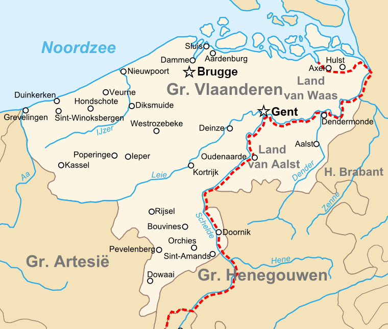
English: Map of the en:County of Flanders in the late 14th centry.
Nederlands: Kaart van het nl:Graafschap Vlaanderen in de Tweede helft van de 14e eeuw. |
| Date | 10 June 2008 (upload date) |
| Source | Own work |
| Author | Sir Iain |
Licensing[edit]
.png&action=edit§ion=2)
| I, the copyright holder of this work, release this work into the public domain. This applies worldwide. In some countries this may not be legally possible; if so: I grant anyone the right to use this work for any purpose, without any conditions, unless such conditions are required by law. |
| Annotations | This image is annotated: View the annotations at Commons |
.png)
File history
Click on a date/time to view the file as it appeared at that time.
| Date/Time | Thumbnail | Dimensions | User | Comment | |
|---|---|---|---|---|---|
| current | 22:48, 22 January 2023 | | 760 × 645 (190 KB) | Le Fou (talk | contribs) | correction |
| 19:35, 10 June 2008 |  | 760 × 645 (207 KB) | Sir Iain (talk | contribs) | {{Information |Description={{en|1=Topographic map of the en:County of Flanders in the late 14th centry.}} {{nl|1=Topografische kaart van het nl:Graafschap Vlaanderen in de Tweede helft van de 14e eeuw.}} |Source=eigen werk (own work) |Author=[[U |
You cannot overwrite this file.
File usage on Commons
The following page uses this file:
File usage on other wikis
The following other wikis use this file:
- Usage on bn.wikipedia.org
- Usage on cs.wikipedia.org
- Usage on de.wikipedia.org
- Usage on de.wiktionary.org
- Usage on el.wikipedia.org
- Usage on en.wikipedia.org
- Usage on es.wikipedia.org
- Usage on et.wikipedia.org
- Usage on fr.wikipedia.org
- Usage on he.wikipedia.org
- Usage on id.wikipedia.org
- Usage on it.wikipedia.org
- Usage on nl.wikipedia.org
- Ronse
- Graafschap Vlaanderen
- Rijks-Vlaanderen
- Kroon-Vlaanderen
- Land van Aalst
- Portaal:Middeleeuwen/Uitgelicht
- Portaal:Middeleeuwen/Uitgelicht/26
- Politieke geschiedenis van Vlaanderen
- Tijdlijn van de Lage Landen (steden en vorstendommen)
- Geschiedenis van de Habsburgse Nederlanden (1482-1556)
- Geschiedenis van de opkomst van vorstendommen en steden in de Lage Landen
- Geschiedenis van Oost-Vlaanderen
- Vliet (Antwerpen)
- Usage on sh.wikipedia.org
- Usage on sl.wikipedia.org
- Usage on vls.wikipedia.org
- Usage on www.wikidata.org
- Usage on zh.wikipedia.org
.png&oldid=870204191)