File:Culloden Moor station site geograph-3345327-by-Ben-Brooksbank.jpg
Jump to navigation
Jump to search
Size of this preview: 800 × 511 pixels. Other resolutions: 320 × 204 pixels | 640 × 408 pixels | 1,172 × 748 pixels.
Original file (1,172 × 748 pixels, file size: 877 KB, MIME type: image/jpeg)
Captions
Captions
Add a one-line explanation of what this file represents
Summary
[edit]
| Description |
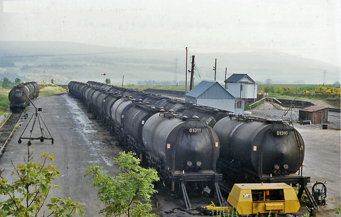
English: Bitumen tank-wagons at Culloden Moor station (site), 1986. View SE, towards Aviemore: ex-Highland Perth - Aviemore - Inverness main line. The station was closed 3/5/65 (goods 27/2/67), so what are all those tank-wagons doing there? |
| Date | |
| Source | From geograph.org.uk |
| Author | Ben Brooksbank |
| Permission (Reusing this file) |
Creative Commons Attribution Share-alike license 2.0 |
| Attribution (required by the license) | Ben Brooksbank / Bitumen tank-wagons at Culloden Moor station (site), 1986 / |
| Camera location | | View this and other nearby images on: OpenStreetMap |
|---|
Taken on 28 June 1986
Licensing
[edit]

|
This image was taken from the Geograph project collection. See this photograph's page on the Geograph website for the photographer's contact details. The copyright on this image is owned by Ben Brooksbank and is licensed for reuse under the Creative Commons Attribution-ShareAlike 2.0 license.
|
This file is licensed under the Creative Commons Attribution-Share Alike 2.0 Generic license.
Attribution: Ben Brooksbank
- You are free:
- to share – to copy, distribute and transmit the work
- to remix – to adapt the work
- Under the following conditions:
- attribution – You must give appropriate credit, provide a link to the license, and indicate if changes were made. You may do so in any reasonable manner, but not in any way that suggests the licensor endorses you or your use.
- share alike – If you remix, transform, or build upon the material, you must distribute your contributions under the same or compatible license as the original.
File history
Click on a date/time to view the file as it appeared at that time.
| Date/Time | Thumbnail | Dimensions | User | Comment | |
|---|---|---|---|---|---|
| current | 14:45, 6 April 2013 | | 1,172 × 748 (877 KB) | Chevin (talk | contribs) | == {{int:filedesc}} == {{Information |Description={{en|1='''Bitumen tank-wagons at Culloden Moor station (site), 1986.'''<br/> View SE, towards Aviemore: ex-Highland Perth - Aviemore - Inverness main line. The station was closed 3/5/65 (goods 27/2/67),... |
You cannot overwrite this file.
File usage on Commons
The following page uses this file:
File usage on other wikis
The following other wikis use this file:
- Usage on en.wikipedia.org