File:Curonian Spit NP 05-2017 img03 aerial view at Muellers Height.jpg
Ir a la navegación
Ir a la búsqueda

Tamaño de esta previsualización: 800 × 500 píxeles. Otras resoluciones: 320 × 200 píxeles | 640 × 400 píxeles | 1024 × 640 píxeles | 1280 × 800 píxeles | 2560 × 1600 píxeles | 4396 × 2747 píxeles.
Archivo original (4396 × 2747 píxeles; tamaño de archivo: 7,03 MB; tipo MIME: image/jpeg)
Leyendas
Leyendas
Añade una explicación corta acerca de lo que representa este archivo
| Descripción |
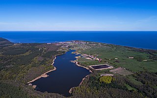
English: Curonian Spit in Kaliningrad Oblast (Russia). Aerial view at Müller's Height. View of Lake Chaika and Rybachiy settlement.
Deutsch: Kurische Nehrung im Kaliningrader Gebiet (Russland). Luftaufnahme an der Müller-Höhe. Aussicht auf Tschaika-See und Rybatschi/Rossitten.
Русский: Куршская коса в Калининградской области (Россия). Аэрофотосъёмка над высотой Мюллера. Вид на озеро Чайка и посёлок Рыбачий.
|
|||
| Fecha | ||||
| Fuente | Trabajo propio | |||
| Autor | A.Savin | |||
| Permiso (Reutilización de este archivo) |
.svg) Just attribute the author: «A.Savin, Wikipedia»; if you have questions — Telegram, or e-mail to wikiphotospace@gmail.com..svg) Просто укажите в качестве автора: «А.Савин, Википедия»; если есть вопрос — телеграм, или эл.почта на wikiphotospace@gmail.com. Kennzeichnen Sie einfach als Autor: «A.Savin, Wikipedia»; falls Sie Fragen haben — Telegram, oder E-Mail an wikiphotospace@gmail.com.
Thank you. |
| Posición de la cámara | | Ubicación de esta y otras imágenes en: OpenStreetMap |
|---|
Esta imagen ha sido subida en el marco de Wiki Loves Earth 2017.
|
 |
Licencia
[editar]
| Copyleft: esta obra de arte es libre; puedes redistribuírla y/o modificarla de acuerdo con los términos de la licencia de arte libre. Encontrarás un ejemplar de esta licencia en la página de Copyleft Attitude, así como también en otros sitios. |
Historial del archivo
Haz clic sobre una fecha y hora para ver el archivo tal como apareció en ese momento.
| Fecha y hora | Miniatura | Dimensiones | Usuario | Comentario | |
|---|---|---|---|---|---|
| actual | 17:29 22 may 2017 | | 4396 × 2747 (7,03 MB) | A.Savin (discusión | contribs.) | {{User:A.Savin/F |Description= {{en|Curonian Spit in Kaliningrad Oblast (Russia). Aerial view at Müller's Height. View of Lake Chaika and Rybachiy settlement.}} {{de|Kurische Nehrung im Kaliningrader Gebiet (Russland). Luftaufnahme an der Müller-Höh... |
No puedes sobrescribir este archivo.
Usos del archivo
Las siguientes páginas usan este archivo:
Uso global del archivo
Las wikis siguientes utilizan este archivo:
- Uso en de.wikipedia.org
- Uso en en.wikipedia.org
- Uso en es.wikipedia.org
- Uso en ko.wikipedia.org
- Uso en lt.wikipedia.org
- Uso en lv.wikipedia.org
- Uso en ru.wikipedia.org
- Uso en www.wikidata.org