File:Czechoslovakia 1939.SVG
Pāriet uz navigāciju
Pāriet uz meklēšanu

Size of this PNG preview of this SVG file: 800 × 322 pikseļi. Citi izmēri: 320 × 129 pikseļi | 640 × 257 pikseļi | 1 024 × 412 pikseļi | 1 280 × 515 pikseļi | 2 560 × 1 030 pikseļi | 1 059 × 426 pikseļi.
Sākotnējais fails (SVG fails, definētais izmērs 1 059 × 426 pikseļi, faila izmērs: 104 KB)
Captions
Captions
Pievieno vienas rindiņas aprakstu, ko šis fails attēlo
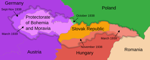
Czechoslovakia's borders in 1939
| Apraksts |
English: Map of Czechoslovakia after 1939
Français : Carte de la Tchécoslovaquie aprés 1939
Русский: Карта Чехословакии после 1939 года
Українська: Карта Чехословаччини після 1939 року |
| Datums | (UTC) |
| Avots | For the info on the map it can be confirmed here: https://encyclopedia.ushmm.org/content/en/gallery/czechoslovakia-maps |
| Autors | 16:36, 13 September 2007 (UTC) |
| Citas versijas |
Derivative works of this file: []
|


|
This SVG file contains embedded text that can be translated into your language, using any capable SVG editor, text editor or the SVG Translate tool. For more information see: About translating SVG files. |
| This is a retouched picture, which means that it has been digitally altered from its original version. The original can be viewed here: First Czechoslovak Republic.SVG:
|
Šis fails tiek izplatīts saskaņā ar licences Creative Commons Atsauce-Līdzīgi Noteikumi 3.0 Vispārējiem noteikumiem.
- Jūs varat brīvi:
- koplietot – kopēt, izplatīt un pārraidīt darbu
- remiksēt – pielāgot darbu
- Saskaņā ar šādiem nosacījumiem:
- atsaucoties – Tev ir jānorāda autors, saite uz licenci un to, vai veiktas kādas izmaiņas. To var darīt jebkādā saprātīgā veidā, bet ne tādā, kas norādītu, ka licencētājs atbalsta tevi vai veidu, kā tu izmanto šo darbu.
- nemainot licenci – Ja tu miksē, pārveido vai izmanto materiālu, tev savs devums jāpublicē ar to pašu vai saderīgu licenci kā oriģināls.
Original upload log[labot šo sadaļu]
This image is a derivative work of the following images:
- Image:First_Czechoslovak_Republic.SVG licensed with Cc-by-sa-3.0
- 2008-06-09T15:42:55Z Themightyquill 1001x471 (403234 Bytes)
- 2008-06-08T23:43:55Z Themightyquill 1001x471 (68801 Bytes)
- 2008-06-08T23:40:33Z Themightyquill 1100x497 (68914 Bytes)
Uploaded with derivativeFX
Faila hronoloģija
Uzklikšķini uz datums/laiks kolonnā esošās saites, lai apskatītos, kā šis fails izskatījās tad.
| Datums/Laiks | Attēls | Izmēri | Dalībnieks | Komentārs | |
|---|---|---|---|---|---|
| tagadējais | 2020. gada 1. janvāris, plkst. 19.47 | 1 059 × 426 (104 KB) | Chiswick Chap (diskusija | devums) | enlarged text | |
| 2010. gada 26. augusts, plkst. 14.30 | 1 059 × 426 (98 KB) | Themightyquill (diskusija | devums) | |||
| 2010. gada 26. augusts, plkst. 14.23 | 1 069 × 434 (97 KB) | Themightyquill (diskusija | devums) | |||
| 2010. gada 2. maijs, plkst. 04.42 | 1 069 × 435 (114 KB) | Themightyquill (diskusija | devums) | Reverted to version as of 04:19, 2 May 2010 | ||
| 2010. gada 2. maijs, plkst. 04.36 | 1 069 × 435 (114 KB) | Mnmazur (diskusija | devums) | Reverted to version as of 23:15, 1 May 2010 | ||
| 2010. gada 2. maijs, plkst. 04.19 | 1 069 × 435 (114 KB) | Themightyquill (diskusija | devums) | Reverted to version as of 00:36, 1 May 2010 | ||
| 2010. gada 1. maijs, plkst. 23.15 | 1 069 × 435 (114 KB) | Mnmazur (diskusija | devums) | Very well, I've kept it a different color, but a color that's more related to the Polish color than the blue is. For a while, I had a hard time ascertaining who was actually annexing it, because unlike the purple of the Sudetenland and Germany, it's comp | ||
| 2010. gada 1. maijs, plkst. 00.36 | 1 069 × 435 (114 KB) | Themightyquill (diskusija | devums) | Reverted to version as of 13:38, 22 June 2008 - it wasn't broken - all the annexations are different colours to make it clear | ||
| 2010. gada 30. aprīlis, plkst. 13.58 | 1 069 × 435 (114 KB) | Mnmazur (diskusija | devums) | Fixing color of Polish annexation. | ||
| 2008. gada 22. jūnijs, plkst. 13.38 | 1 069 × 435 (114 KB) | Themightyquill (diskusija | devums) |
Šo failu nevar pārrakstīt.
Faila lietojums
Šo failu izmanto šajās 29 lapās:
- Atlas of Czechoslovakia
- Atlas of Hungary
- Atlas of Slovakia
- Atlas of World War II
- Munich Agreement
- User:Magog the Ogre/Maps of conflicts/2020 January
- User:Themightyquill
- File:Czechoslovakia 1939.SVG
- File:Czechoslovakia 1939 be-x-old.SVG
- File:Czechoslovakia 1939 br.SVG
- File:Czechoslovakia 1939 ca.SVG
- File:Czechoslovakia 1939 de.svg
- File:Czechoslovakia 1939 es.SVG
- File:Czechoslovakia 1939 hu.svg
- File:Czechoslovakia 1939 it.SVG
- File:Czechoslovakia 1939 ka.png
- File:Czechoslovakia 1939 lv.svg
- File:Czechoslovakia 1939 no.svg
- File:Czechoslovakia 1939 ru.SVG
- File:Czechoslovakia 1939 sr.SVG
- File:Czechoslovakia 1939 sv.svg
- File:Czechoslovakia 1939 zh.svg
- File:Tchécoslovaquie 1939.SVG
- File:Territorial changes of Poland 1939c.jpg
- File:Československa 1939 cs.SVG
- File:Československa 1939 sk.SVG
- File talk:Annexation of Southern and Eastern Ukraine.svg
- Template:Other versions/Czechoslovakia 1939
- Category:First Vienna Award
Globālais faila lietojums
Šīs Vikipēdijas izmanto šo failu:
- Izmantojums af.wikipedia.org
- Izmantojums ar.wikipedia.org
- Izmantojums be.wikipedia.org
- Izmantojums bg.wikipedia.org
- Izmantojums bs.wikipedia.org
- Izmantojums ca.wikipedia.org
- Izmantojums cy.wikipedia.org
- Izmantojums el.wikipedia.org
- Izmantojums en.wikipedia.org
- Czechoslovakia
- Irredentism
- Occupation of Czechoslovakia (1938–1945)
- History of Czechoslovakia
- List of irredentist claims or disputes
- Territorial evolution of Germany
- Territorial evolution of Poland
- Wikipedia talk:WikiProject Czech Republic/Archive 2
- Gauliga Sudetenland
- Gauliga Böhmen und Mähren
- Wikipedia talk:WikiProject Maps/Archive 5
- File talk:Nazi-Soviet 1941.png
- Wikipedia talk:WikiProject Slovakia/Archive 2
- The Holocaust in Bohemia and Moravia
- The Holocaust in the Sudetenland
- User:Falcaorib/Czechoslovakia
- Izmantojums es.wikipedia.org
- Izmantojums et.wikipedia.org
- Izmantojums fi.wikipedia.org
- Izmantojums fr.wikipedia.org
- Izmantojums he.wikipedia.org
- Izmantojums hr.wikipedia.org
- Izmantojums hu.wikipedia.org
- Izmantojums id.wikipedia.org
- Izmantojums it.wikipedia.org
- Izmantojums ja.wikipedia.org
- Izmantojums ka.wikipedia.org
Skatīt šī faila pilno globālo izmantojumu.