File:DETAIL, NORTHWEST AND SOUTHWEST SIDES, UPPER PORTION OF TOWER - Mispillion Lighthouse, Beacon Tower, South bank of Mispillion River at it confluence with Delaware River at HAER DEL,3-MILF.V,2A-8.tif
Jump to navigation
Jump to search

Size of this JPG preview of this TIF file: 403 × 599 pixels. Other resolutions: 161 × 240 pixels | 323 × 480 pixels | 517 × 768 pixels | 689 × 1,024 pixels | 1,379 × 2,048 pixels | 3,240 × 4,813 pixels.
Original file (3,240 × 4,813 pixels, file size: 14.87 MB, MIME type: image/tiff)
Captions
Captions
Add a one-line explanation of what this file represents
Summary[edit]
| Photographer |
Boucher, Jack E. Related names:
|
|||
| Title |
DETAIL, NORTHWEST AND SOUTHWEST SIDES, UPPER PORTION OF TOWER - Mispillion Lighthouse, Beacon Tower, South bank of Mispillion River at it confluence with Delaware River at northeast end of County Road 203, 7 miles east of Milford, Milford, Sussex County, DE |
|||
| Depicted place | Delaware; Sussex County; Milford | |||
| Date | 1992 | |||
| Dimensions | height: 7 in (17.7 cm); width: 5 in (12.7 cm) | |||
| Current location |
Library of Congress Prints and Photographs Division Washington, D.C. 20540 USA http://hdl.loc.gov/loc.pnp/pp.print |
|||
| Accession number |
HAER DEL,3-MILF.V,2A-8 |
|||
| Credit line |
|
|||
| Notes |
|
|||
| Source | https://www.loc.gov/pictures/item/de0514.photos.384121p | |||
| Permission (Reusing this file) |
|

| Object location | | View this and other nearby images on: OpenStreetMap |
|---|
File history
Click on a date/time to view the file as it appeared at that time.
| Date/Time | Thumbnail | Dimensions | User | Comment | |
|---|---|---|---|---|---|
| current | 14:54, 28 March 2022 |  | 3,240 × 4,813 (14.87 MB) | MSGJ (talk | contribs) | Cropped 20 % horizontally, 16 % vertically using CropTool with precise mode. |
| 01:30, 11 July 2014 | 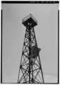 | 4,050 × 5,714 (22.07 MB) | Fæ (talk | contribs) | GWToolset: Creating mediafile for Fæ. HABS 09 July 2014 (801:1000) |
You cannot overwrite this file.
File usage on Commons
The following page uses this file:
File usage on other wikis
The following other wikis use this file:
- Usage on de.wikipedia.org
- Usage on en.wikipedia.org
- Usage on www.wikidata.org