File:DISTANT VIEW OF FRONT (NORTHWEST FACADE) - Wheeler House, Orford Street, Orford, Grafton County, NH HABS NH,5-ORF,3-6.tif
Jump to navigation
Jump to search

Size of this JPG preview of this TIF file: 800 × 573 pixels. Other resolutions: 320 × 229 pixels | 640 × 458 pixels | 1,024 × 733 pixels | 1,280 × 916 pixels | 2,560 × 1,832 pixels | 5,000 × 3,579 pixels.
Original file (5,000 × 3,579 pixels, file size: 17.07 MB, MIME type: image/tiff)
Captions
Captions
Add a one-line explanation of what this file represents
Summary[edit]
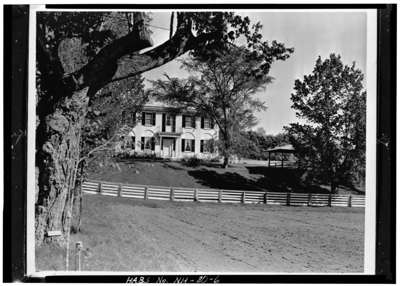
| DISTANT VIEW OF FRONT (NORTHWEST FACADE) - Wheeler House, Orford Street, Orford, Grafton County, NH
( |
|||||||||||||||||||||||||||
|---|---|---|---|---|---|---|---|---|---|---|---|---|---|---|---|---|---|---|---|---|---|---|---|---|---|---|---|
| Photographer |
Related names:
|
||||||||||||||||||||||||||
| Title |
DISTANT VIEW OF FRONT (NORTHWEST FACADE) - Wheeler House, Orford Street, Orford, Grafton County, NH |
||||||||||||||||||||||||||
| Depicted place | New Hampshire; Grafton County; Orford | ||||||||||||||||||||||||||
| Date | 1936 | ||||||||||||||||||||||||||
| Dimensions | 5 x 7 in. | ||||||||||||||||||||||||||
| Current location |
Library of Congress Prints and Photographs Division Washington, D.C. 20540 USA http://hdl.loc.gov/loc.pnp/pp.print |
||||||||||||||||||||||||||
| Accession number |
HABS NH,5-ORF,3-6 |
||||||||||||||||||||||||||
| Credit line |
|
||||||||||||||||||||||||||
| Notes |
|
||||||||||||||||||||||||||
| Source | https://www.loc.gov/pictures/item/nh0037.photos.104976p | ||||||||||||||||||||||||||
| Permission (Reusing this file) |
|
||||||||||||||||||||||||||
_in_suit.jpg)

| Object location | | View this and other nearby images on: OpenStreetMap |
|---|
File history
Click on a date/time to view the file as it appeared at that time.
| Date/Time | Thumbnail | Dimensions | User | Comment | |
|---|---|---|---|---|---|
| current | 03:17, 29 July 2014 |  | 5,000 × 3,579 (17.07 MB) | Fæ (talk | contribs) | GWToolset: Creating mediafile for Fæ. HABS 24 July 2014 (2001:2300) |
You cannot overwrite this file.
File usage on Commons
The following page uses this file: