File:Descripcion de las costas, islas placeres, i bajos delas, Indias Occidentales, LOC 75695815.tif
Jump to navigation
Jump to search

Size of this JPG preview of this TIF file: 800 × 519 pixels. Other resolutions: 320 × 208 pixels | 640 × 416 pixels | 1,024 × 665 pixels | 1,280 × 831 pixels | 2,560 × 1,662 pixels | 11,202 × 7,274 pixels.
Original file (11,202 × 7,274 pixels, file size: 233.13 MB, MIME type: image/tiff)
Captions
Captions
Add a one-line explanation of what this file represents
Summary
[edit]| Warning | The original file is very high-resolution. It might not load properly or could cause your browser to freeze when opened at full size. |
|---|
| Description |
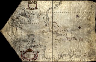
English: Scale ca. 1:5,000,000. Manuscript, pen-and-ink and watercolor, on vellum. Shows the Atlantic coast of southern U.S., Mexico, Central America, and northern South America. "Sibre para Domingo de Belasco Pilo to del Paqui Bot Delrei el Cortes." LC Maps of North America, 1750-1789, 1694 LC Luso-Hispanic World, 30 LC Nautical charts on vellum Available also through the Library of Congress Web site as a raster image. Vault AACR2: 650/1; 650/2; 651/3 |
||
| Title | Descripcion de las costas, islas placeres, i bajos delas, Indias Occidentales, | ||
| Shelf ID | G4391.P5 1765 .E8 | ||
| Date | |||
| Source | https://www.loc.gov/item/75695815/ | ||
| Author | Espinosa, Pedro Alcantara | ||
| Permission (Reusing this file) |
|
||
| Other versions |
|
||
| Location | Caribbean Area | ||
| Part of | Cultural Landscapes · Military Battles And Campaigns · Catalog · American Memory · Geography And Map Division · American Revolution And Its Era: Maps And Charts Of North America And The West Indies, 1750-1789 | ||
| Subject | Maps, Manuscript · Caribbean Area · Coasts · Nautical Charts · Maps · Early Works To 1800 |


Licensing
[edit]|
This is a faithful photographic reproduction of a two-dimensional, public domain work of art. The work of art itself is in the public domain for the following reason:
The official position taken by the Wikimedia Foundation is that "faithful reproductions of two-dimensional public domain works of art are public domain".
This photographic reproduction is therefore also considered to be in the public domain in the United States. In other jurisdictions, re-use of this content may be restricted; see Reuse of PD-Art photographs for details. | ||||
File history
Click on a date/time to view the file as it appeared at that time.
| Date/Time | Thumbnail | Dimensions | User | Comment | |
|---|---|---|---|---|---|
| current | 19:31, 22 May 2018 |  | 11,202 × 7,274 (233.13 MB) | Fæ (talk | contribs) | LOC Maps https://www.loc.gov/item/75695815/ #13413 |
You cannot overwrite this file.
File usage on Commons
The following page uses this file: