File:Deutschland topo.jpg
Jump to navigation
Jump to search
Size of this preview: 454 × 599 pixels. Other resolutions: 182 × 240 pixels | 364 × 480 pixels | 582 × 768 pixels | 776 × 1,024 pixels | 2,011 × 2,654 pixels.
Original file (2,011 × 2,654 pixels, file size: 1.76 MB, MIME type: image/jpeg)
Captions
Captions
Add a one-line explanation of what this file represents
| Description |
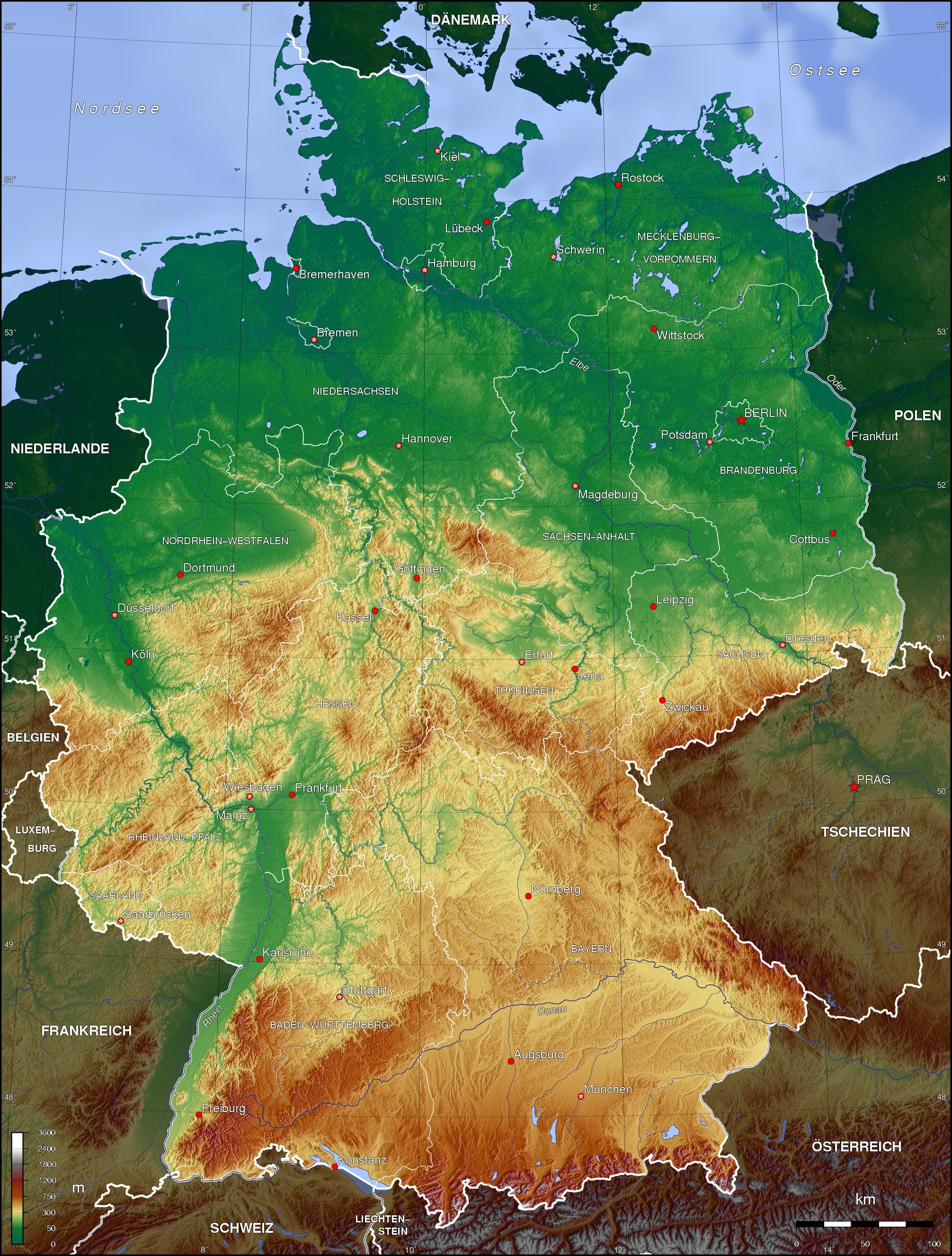
English: Topographic map of Germany (Borders of the States of Germany approximately as of 1990) Deutsch: Topografische Karte Deutschlands (Verlauf der Ländergrenzen etwa Stand 1990) |
| Date | |
| Source | Own work |
| Author | Botaurus-stellaris |
The map has been created with the Generic Mapping Tools: https://www.generic-mapping-tools.org/ using one or more of these public-domain datasets for the relief:
|

|
Permission is granted to copy, distribute and/or modify this document under the terms of the GNU Free Documentation License, Version 1.2 or any later version published by the Free Software Foundation; with no Invariant Sections, no Front-Cover Texts, and no Back-Cover Texts. A copy of the license is included in the section entitled GNU Free Documentation License. |
| This file is licensed under the Creative Commons Attribution-Share Alike 3.0 Unported license. | ||
| ||
| This licensing tag was added to this file as part of the GFDL licensing update. |
derivative works
[edit]
Derivative works of this file: Deutschland topo cropped.jpg
File history
Click on a date/time to view the file as it appeared at that time.
| Date/Time | Thumbnail | Dimensions | User | Comment | |
|---|---|---|---|---|---|
| current | 23:43, 16 November 2006 | | 2,011 × 2,654 (1.76 MB) | Botaurus-stellaris (talk | contribs) |
You cannot overwrite this file.
File usage
The following 7 pages use this file:
Global file usage
The following other wikis use this file:
- Usage on af.wikipedia.org
- Usage on als.wikipedia.org
- Usage on ar.wikipedia.org
- Usage on ast.wikipedia.org
- Usage on azb.wikipedia.org
- Usage on az.wikipedia.org
- Usage on be-tarask.wikipedia.org
- Usage on be.wikipedia.org
- Usage on bn.wikipedia.org
- Usage on bo.wikipedia.org
- Usage on bs.wikipedia.org
- Usage on bxr.wikipedia.org
- Usage on ce.wikipedia.org
- Usage on ckb.wikipedia.org
- Usage on cs.wikipedia.org
- Usage on da.wikipedia.org
- Usage on de.wikipedia.org
- Karte (Kartografie)
- Benutzer:Nainoa
- Benutzer:Meisel
- Benutzer:Kiezkicker
- Bucht
- Wikipedia:WikiProjekt Kommunen und Landkreise in Deutschland
- Benutzer:Meph666/Galerie
- Benutzer:Metrics
- Benutzer:Kuellmann.de
- Benutzer:Paulimausi
- Benutzer:RMeier
- Wikipedia:Kandidaten für exzellente Bilder/Archiv2005/10
- Benutzer:Dr Nibbles
- Benutzer:Tjö
- Geographie Deutschlands
- Benutzer:Neurowiki
- Benutzer:MyChaOS
- Benutzer:Behrev
- Benutzer:Stefan Zwierlein
View more global usage of this file.