File:Developing oxbow lake - geograph.org.uk - 830965.jpg
Jump to navigation
Jump to search
No higher resolution available.
Developing_oxbow_lake_-_geograph.org.uk_-_830965.jpg (640 × 480 pixels, file size: 105 KB, MIME type: image/jpeg)
Captions
Captions
Add a one-line explanation of what this file represents
Summary
[edit]
| Description |
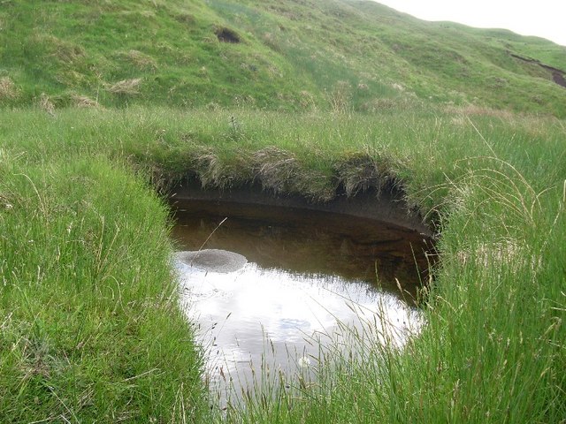
English: Developing oxbow lake This meander is developing into an oxbow lake, as evidenced by the deposit to the left in this mage. Eventually the meander will be cut off entirely from the burn. As Overtoun Burn is in the upper stages of the river model, such development is unusual in this type of water feature. |
| Date | |
| Source | From geograph.org.uk |
| Author | Stephen Sweeney |
| Attribution (required by the license) | Stephen Sweeney / Developing oxbow lake / |
| Camera location | | View this and other nearby images on: OpenStreetMap |
|---|
_heading:45.00&language=en)
| Object location | | View this and other nearby images on: OpenStreetMap |
|---|
_heading:45.00&language=en)
Licensing
[edit]

|
This image was taken from the Geograph project collection. See this photograph's page on the Geograph website for the photographer's contact details. The copyright on this image is owned by Stephen Sweeney and is licensed for reuse under the Creative Commons Attribution-ShareAlike 2.0 license.
|
This file is licensed under the Creative Commons Attribution-Share Alike 2.0 Generic license.
Attribution: Stephen Sweeney
- You are free:
- to share – to copy, distribute and transmit the work
- to remix – to adapt the work
- Under the following conditions:
- attribution – You must give appropriate credit, provide a link to the license, and indicate if changes were made. You may do so in any reasonable manner, but not in any way that suggests the licensor endorses you or your use.
- share alike – If you remix, transform, or build upon the material, you must distribute your contributions under the same or compatible license as the original.
File history
Click on a date/time to view the file as it appeared at that time.
| Date/Time | Thumbnail | Dimensions | User | Comment | |
|---|---|---|---|---|---|
| current | 19:05, 20 February 2011 | | 640 × 480 (105 KB) | GeographBot (talk | contribs) | == {{int:filedesc}} == {{Information |description={{en|1=Developing oxbow lake This meander is developing into an oxbow lake, as evidenced by the deposit to the left in this mage. Eventually the meander will be cut off entirely from the burn. As Overtoun |
You cannot overwrite this file.
File usage on Commons
There are no pages that use this file.