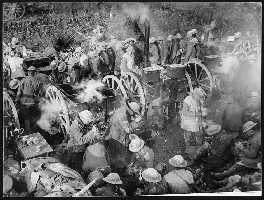
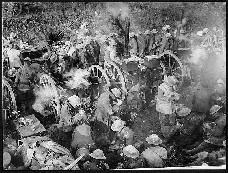
File:Dinner time on the Ancre (4687905371).jpg
Jump to navigation
Jump to search
Size of this preview: 790 × 600 pixels. Other resolutions: 316 × 240 pixels | 633 × 480 pixels | 1,000 × 759 pixels.
Original file (1,000 × 759 pixels, file size: 148 KB, MIME type: image/jpeg)
Captions
Captions
Add a one-line explanation of what this file represents
Summary
[edit].jpg&action=edit§ion=1)
| Description |
English: Soldiers, apparently near the Front, getting fed from mobile army kitchens. In the background men are lining up for their ration, while in the foreground others are sitting or standing and eating soup or stew from bowls and tins. To the left there is a table set with a jug, a can-opener and tins of what may be milk. These field ovens basically consist of large metal canisters set into a framework over built-in ovens. This photograph may have been taken during the Allied advance in the Ancre area in the spring of 1917, as that was a cold, frosty winter. |
| Date | |
| Source | https://www.flickr.com/photos/nlscotland/4687905371/ |
| Author | National Library of Scotland |
| Permission (Reusing this file) |
At the time of upload, the image license was automatically confirmed using the Flickr API. For more information see Flickr API detail. |
| Flickr sets |
|
| Flickr tags |
|
| Camera location | | View this and other nearby images on: OpenStreetMap |
|---|
.jpg¶ms=051.096248_N_0004.200610_E_globe:Earth_type:camera__&language=en)
Licensing
[edit].jpg&action=edit§ion=2)
This image was taken from Flickr's The Commons. The uploading organization may have various reasons for determining that no known copyright restrictions exist, such as:
More information can be found at https://flickr.com/commons/usage/. Please add additional copyright tags to this image if more specific information about copyright status can be determined. See Commons:Licensing for more information. |
| This image was originally posted to Flickr by National Library of Scotland at https://flickr.com/photos/14456531@N07/4687905371. It was reviewed on 16 November 2016 by FlickreviewR and was confirmed to be licensed under the terms of the No known copyright restrictions. |
File history
Click on a date/time to view the file as it appeared at that time.
| Date/Time | Thumbnail | Dimensions | User | Comment | |
|---|---|---|---|---|---|
| current | 00:44, 8 January 2022 | | 1,000 × 759 (148 KB) | Ich (talk | contribs) | https://deriv.nls.uk/dcn30/7440/74408989.30.jpg |
| 12:51, 16 November 2016 |  | 600 × 455 (60 KB) | Fæ (talk | contribs) | National Library of Scotland, Set 72157624150609895, ID 4687905371, Original title Dinner time on the Ancre |
You cannot overwrite this file.
File usage on Commons
There are no pages that use this file.
File usage on other wikis
The following other wikis use this file:
- Usage on de.wikipedia.org
.jpg&oldid=899138978)