File:Dumbarton Castle - geograph.org.uk - 501609.jpg
Jump to navigation
Jump to search
No higher resolution available.
Dumbarton_Castle_-_geograph.org.uk_-_501609.jpg (640 × 480 pixels, file size: 84 KB, MIME type: image/jpeg)
Captions
Captions
Add a one-line explanation of what this file represents
Summary[edit]
| Description |
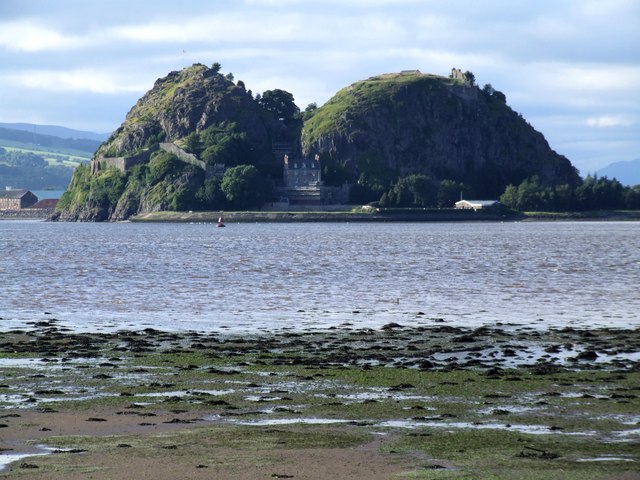
English: Dumbarton Castle A long shot from across the River Clyde,taken near the start of the M8.
South of the centre of Dumbarton rises the 240ft high twin peaked volcanic plug of Dumbarton Rock, with the River Clyde on one side and the River Leven on two more. The castle is in the care of Historic Scotland. |
| Date | |
| Source | From geograph.org.uk |
| Author | Dave Hitchborne |
| Attribution (required by the license) | Dave Hitchborne / Dumbarton Castle / |
| Camera location | | View this and other nearby images on: OpenStreetMap |
|---|
_heading:337.00&language=en)
| Object location | | View this and other nearby images on: OpenStreetMap |
|---|
_heading:337.00&language=en)
Licensing[edit]

|
This image was taken from the Geograph project collection. See this photograph's page on the Geograph website for the photographer's contact details. The copyright on this image is owned by Dave Hitchborne and is licensed for reuse under the Creative Commons Attribution-ShareAlike 2.0 license.
|
This file is licensed under the Creative Commons Attribution-Share Alike 2.0 Generic license.
Attribution: Dave Hitchborne
- You are free:
- to share – to copy, distribute and transmit the work
- to remix – to adapt the work
- Under the following conditions:
- attribution – You must give appropriate credit, provide a link to the license, and indicate if changes were made. You may do so in any reasonable manner, but not in any way that suggests the licensor endorses you or your use.
- share alike – If you remix, transform, or build upon the material, you must distribute your contributions under the same or compatible license as the original.
File history
Click on a date/time to view the file as it appeared at that time.
| Date/Time | Thumbnail | Dimensions | User | Comment | |
|---|---|---|---|---|---|
| current | 18:03, 19 October 2015 | | 640 × 480 (84 KB) | Rodhullandemu (talk | contribs) | Full-sized image |
| 08:18, 5 February 2011 |  | 60 × 60 (2 KB) | GeographBot (talk | contribs) | == {{int:filedesc}} == {{Information |description={{en|1=Dumbarton Castle A long shot from across the River Clyde,taken near the start of the M8. South of the centre of Dumbarton rises the 240ft high twin peaked volcanic plug of Dumbarton Rock, with t |
You cannot overwrite this file.
File usage
The following page uses this file:
- File:Dumbarton Castle.jpg (file redirect)
Global file usage
The following other wikis use this file:
- Usage on el.wikipedia.org
- Usage on en.wikipedia.org
- Usage on es.wikipedia.org
- Usage on eu.wikipedia.org
- Usage on it.wikipedia.org
- Usage on kk.wikipedia.org
- Usage on mt.wikipedia.org
- Usage on nl.wikipedia.org
- Usage on ru.wikipedia.org
- Usage on uz.wikipedia.org
- Usage on vi.wikipedia.org