File:EAST (REAR) AND NORTH (SIDE) ELEVATIONS OF BUILDING. VIEW TO SOUTHWEST. - Plattsburgh Air Force Base, Petroleum Operations Building, Delaware Street, Plattsburgh, Clinton County, NY HAER NY-326-AD-3.tif
Jump to navigation
Jump to search

Size of this JPG preview of this TIF file: 738 × 600 pixels. Other resolutions: 295 × 240 pixels | 591 × 480 pixels | 945 × 768 pixels | 1,260 × 1,024 pixels | 2,519 × 2,048 pixels | 5,230 × 4,252 pixels.
Original file (5,230 × 4,252 pixels, file size: 21.21 MB, MIME type: image/tiff)
Captions
Captions
Add a one-line explanation of what this file represents
Summary[edit]
| EAST (REAR) AND NORTH (SIDE) ELEVATIONS OF BUILDING. VIEW TO SOUTHWEST. - Plattsburgh Air Force Base, Petroleum Operations Building, Delaware Street, Plattsburgh, Clinton County, NY | ||||
|---|---|---|---|---|
| Photographer |
Fraser, Clayton B. |
|||
| Title |
EAST (REAR) AND NORTH (SIDE) ELEVATIONS OF BUILDING. VIEW TO SOUTHWEST. - Plattsburgh Air Force Base, Petroleum Operations Building, Delaware Street, Plattsburgh, Clinton County, NY |
|||
| Depicted place | New York; Clinton County; Plattsburgh | |||
| Date | 2000 | |||
| Dimensions | 4 x 5 in. | |||
| Current location |
Library of Congress Prints and Photographs Division Washington, D.C. 20540 USA http://hdl.loc.gov/loc.pnp/pp.print |
|||
| Accession number |
HAER NY-326-AD-3 |
|||
| Credit line |
|
|||
| Notes |
|
|||
| Source | https://www.loc.gov/pictures/item/ny1894.photos.202086p | |||
| Permission (Reusing this file) |
|
|||

| Object location | | View this and other nearby images on: OpenStreetMap |
|---|
File history
Click on a date/time to view the file as it appeared at that time.
| Date/Time | Thumbnail | Dimensions | User | Comment | |
|---|---|---|---|---|---|
| current | 13:32, 1 August 2014 | 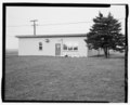 | 5,230 × 4,252 (21.21 MB) | Fæ (talk | contribs) | GWToolset: Creating mediafile for Fæ. HABS 1 Aug (2301:2600) missing |
You cannot overwrite this file.
File usage on Commons
The following page uses this file: