File:EU-Poland.svg
跳去導覽
跳去搵嘢

呢個「SVG」檔案嘅呢個「PNG」預覽嘅大細:713 × 600 像素。 第啲解像度:285 × 240 像素 | 571 × 480 像素 | 913 × 768 像素 | 1,218 × 1,024 像素 | 2,435 × 2,048 像素 | 2,045 × 1,720 像素。
原本檔案 (SVG檔案,表面大細: 2,045 × 1,720 像素,檔案大細:7.33 MB)
Captions
Captions
Add a one-line explanation of what this file represents
EU and Poland
польша
摘要
[編輯]Polski:
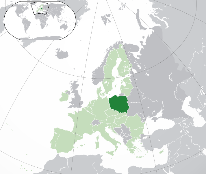
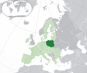
(Green) Polska.
(Light-green) Unia Europejska (UE).
(Gray) Europa.
(Light-gray) Inne terytoria.
| 描述 |
English: (Dark-Green) Poland. (Light-Green) The rest of the European Union (EU). (Dark-gray) The rest of Europe. (Light-gray) The surrounding region.
See also: |
| SVG genesis | |
| 日期 | |
| 來源 | Own work based on: Location European nation states.svg |
| 作者 | NuclearVacuum |
| Other versions |
|
| SVG genesis |


協議
[編輯]
I, the copyright holder of this work, hereby publish it under the following licenses:
呢個檔案用共享創意 姓名標示-非商業性-相同方式分享3.0 未本地化版本條款授權。
- 你可以:
- 去分享 – 複製、發佈同傳播呢個作品
- 再改 – 創作演繹作品
- 要遵照下面嘅條件:
- 署名 – 你一定要畀合適嘅表彰、畀返指向呢個授權條款嘅連結,同埋寫明有無改過嚟。你可以用任何合理方式去做,但唔可以用任何方式暗示授權人認可咗你或者你嘅使用方式。
- 相同方式分享 – 如果你用任何方式改過呢個作品,你必須要用返原本或者相似嘅條款發佈。

|
根據自由軟體基金會發佈嘅無固定段落、封面文字同封底文字GNU自由文件授權條款第1.2或打後嘅版本,你獲授權可以重製、散佈同埋修改爾份文件。授權條款嘅副本喺章節GNU自由文件授權條款。 |
你可以揀你想用嘅牌照。
檔案歷史
撳個日期/時間去睇響嗰個時間出現過嘅檔案。
| 日期/時間 | 縮圖 | 尺寸 | 用戶 | 註解 | |
|---|---|---|---|---|---|
| 現時 | 2020年2月1號 (六) 05:19 | | 2,045 × 1,720(7.33 MB) | Rob984(傾偈 | 貢獻) | UK and Gibraltar have left the EU. New base which includes all of Portugal's islands within frame, as well as Arctic Russian islands part of Europe. Also fixed Flevoland in the Netherlands. |
| 2016年10月25號 (二) 20:34 |  | 2,045 × 1,720(7.32 MB) | Giorgi Balakhadze(傾偈 | 貢獻) | fix | |
| 2015年12月24號 (四) 09:25 |  | 2,045 × 1,720(7.33 MB) | Nordwestern(傾偈 | 貢獻) | Per original framework and Commons' rules. Agree with A2D2. | |
| 2015年3月18號 (三) 15:58 |  | 2,045 × 1,720(7.38 MB) | Mapclean(傾偈 | 貢獻) | Reverted to Leftcry's version, please go to your talk page | |
| 2015年2月21號 (六) 14:10 |  | 2,045 × 1,720(2.61 MB) | VS6507(傾偈 | 貢獻) | Spain. Greece. Slovakia. Cyprus. Romania VETO | |
| 2014年11月16號 (日) 19:34 |  | 2,045 × 1,720(7.38 MB) | Leftcry(傾偈 | 貢獻) | Reverted to version as of 15:48, 6 August 2014 Please go to your talk page | |
| 2014年11月16號 (日) 16:36 |  | 2,045 × 1,720(2.61 MB) | A2D2(傾偈 | 貢獻) | The map must show the original de-jure status with no breakaway regions, as it was originally created. An alternative map showing the de-facto status with breakaway regions needs to be created instead. | |
| 2014年8月6號 (三) 15:48 |  | 2,045 × 1,720(7.38 MB) | Rob984(傾偈 | 貢獻) | Improved version: More accurate coastline, borders, etc. Added Gradient and Longitude and latitude lines. Sudan border. | |
| 2013年7月1號 (一) 09:31 |  | 2,045 × 1,720(2.61 MB) | U5K0(傾偈 | 貢獻) | croatia | |
| 2009年10月23號 (五) 14:41 |  | 2,045 × 1,720(2.59 MB) | NuclearVacuum(傾偈 | 貢獻) | consensus version |
你無得衾咗個檔案。
檔案用途
以下嘅33版用到呢個檔:
- Atlas of Poland
- Forum Ostwest
- User:Kolja21/Location State EU Europe
- User:Mr Taz~commonswiki/comparative federalism
- User:NuclearVacuum
- File:EU-Austria.svg
- File:EU-Belgium.svg
- File:EU-Bulgaria.svg
- File:EU-Croatia.svg
- File:EU-Cyprus.svg
- File:EU-Czech Republic.svg
- File:EU-Denmark.svg
- File:EU-Estonia.svg
- File:EU-Finland.svg
- File:EU-France.svg
- File:EU-Germany.svg
- File:EU-Greece.svg
- File:EU-Hungary.svg
- File:EU-Ireland.svg
- File:EU-Italy.svg
- File:EU-Latvia.svg
- File:EU-Lithuania.svg
- File:EU-Poland.svg
- File:EU-United Kingdom.svg
- File:Location Belgium EU Europe.png
- File:Location Bulgaria EU Europe.png
- File:Location Cyprus EU Europe.png
- File:Location France EU Europe.png
- File:Location Germany EU Europe.png
- File:Location Netherlands EU Europe.png
- File:Location Poland EU Europe.png
- File:Location Portugal EU Europe.png
- Category:Relations of the European Union and Poland
全域檔案使用情況
下面嘅維基都用緊呢個檔案:
- ace.wikipedia.org嘅使用情況
- ady.wikipedia.org嘅使用情況
- af.wikipedia.org嘅使用情況
- ami.wikipedia.org嘅使用情況
- ar.wikipedia.org嘅使用情況
- العلاقات البولندية السعودية
- مستخدم:ElWaliElAlaoui/ملعب 8
- معاملة المثليين في بولندا
- مستخدم:جار الله/قائمة صور مقالات العلاقات الثنائية
- العلاقات الأمريكية البولندية
- العلاقات الأنغولية البولندية
- العلاقات البولندية الكورية الجنوبية
- العلاقات الإريترية البولندية
- العلاقات البولندية السويسرية
- العلاقات البولندية الليختنشتانية
- العلاقات البولندية البوليفية
- العلاقات البولندية الموزمبيقية
- العلاقات الألبانية البولندية
- العلاقات البلجيكية البولندية
- العلاقات الإثيوبية البولندية
- العلاقات البولندية البيلاروسية
- العلاقات البولندية الطاجيكستانية
- العلاقات البولندية الروسية
- العلاقات الأرجنتينية البولندية
- العلاقات البولندية الغامبية
- العلاقات البولندية القبرصية
- العلاقات البولندية السيراليونية
- العلاقات البولندية النيبالية
- العلاقات البولندية الليبيرية
- العلاقات التشيكية البولندية
- العلاقات البولندية الميانمارية
- العلاقات البولندية الكندية
- العلاقات البولندية الزيمبابوية
- العلاقات الإسرائيلية البولندية
- العلاقات البالاوية البولندية
- العلاقات البولندية المالية
- العلاقات البولندية النيجيرية
- العلاقات اليمنية البولندية
- العلاقات البولندية الفانواتية
- العلاقات الغابونية البولندية
- العلاقات البنمية البولندية
- العلاقات البولندية الكوبية
- العلاقات البولندية الجورجية
- العلاقات البولندية التونسية
- العلاقات البولندية الكورية الشمالية
- العلاقات الهندية البولندية
- العلاقات اليابانية البولندية
- العلاقات الإيطالية البولندية
- العلاقات البولندية الناوروية
- العلاقات الأسترالية البولندية
- العلاقات البولندية الزامبية
睇呢個檔案嘅更多全域使用情況。