File:EXTERIOR, NORTHEAST REAR - Moorefields, State Route 1135, Hillsborough, Orange County, NC HABS NC,68-HILBO,9-2.tif
Jump to navigation
Jump to search

Size of this JPG preview of this TIF file: 800 × 576 pixels. Other resolutions: 320 × 230 pixels | 640 × 461 pixels | 1,024 × 737 pixels | 1,280 × 921 pixels | 2,560 × 1,842 pixels | 5,000 × 3,598 pixels.
Original file (5,000 × 3,598 pixels, file size: 17.16 MB, MIME type: image/tiff)
Captions
Captions
Add a one-line explanation of what this file represents
Summary[edit]
| EXTERIOR, NORTHEAST REAR - Moorefields, State Route 1135, Hillsborough, Orange County, NC | ||||
|---|---|---|---|---|
| Photographer |
Related names:
|
|||
| Title |
EXTERIOR, NORTHEAST REAR - Moorefields, State Route 1135, Hillsborough, Orange County, NC |
|||
| Depicted place | North Carolina; Orange County; Hillsborough | |||
| Date | Documentation compiled after 1933 | |||
| Dimensions | 5 x 7 in. | |||
| Current location |
Library of Congress Prints and Photographs Division Washington, D.C. 20540 USA http://hdl.loc.gov/loc.pnp/pp.print |
|||
| Accession number |
HABS NC,68-HILBO,9-2 |
|||
| Credit line |
|
|||
| Notes |
A family cemetery at Moorefields contains graves of various members of the Moore, Nash, and Waddell families.
|
|||
| Source | https://www.loc.gov/pictures/item/nc0064.photos.102588p | |||
| Permission (Reusing this file) |
|
|||

| Object location | | View this and other nearby images on: OpenStreetMap |
|---|
File history
Click on a date/time to view the file as it appeared at that time.
| Date/Time | Thumbnail | Dimensions | User | Comment | |
|---|---|---|---|---|---|
| current | 21:21, 28 July 2014 | 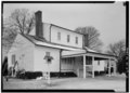 | 5,000 × 3,598 (17.16 MB) | Fæ (talk | contribs) | GWToolset: Creating mediafile for Fæ. HABS 24 July 2014 (2001:2300) |
You cannot overwrite this file.
File usage on Commons
The following page uses this file: