File:East Riding of Yorkshire UK location map.svg
Spring til navigation
Spring til søgning

Size of this PNG preview of this SVG file: 772 × 600 pixels. Andre opløsninger: 309 × 240 pixels | 618 × 480 pixels | 989 × 768 pixels | 1.280 × 994 pixels | 2.560 × 1.989 pixels | 1.425 × 1.107 pixels.
Oprindelig fil (SVG fil, basisstørrelse 1.425 × 1.107 pixels, filstørrelse: 1,33 MB)
Captions
Captions
Tilføj en kort forklaring på en enkelt linje om hvad filen viser
| Beskrivelse |
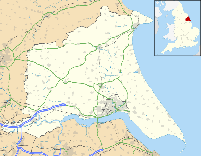
Map of the East Riding of Yorkshire, UK with the following information shown:
Equirectangular map projection on WGS 84 datum, with N/S stretched 165% Geographic limits:
|
| Dato | |
| Kilde |
|
| Forfatter | Nilfanion, created using Ordnance Survey data |
| Tilladelse (Genbrug af denne fil) |
Denne fil er udgivet under Creative Commons Kreditering-Del på samme vilkår 3.0 Ikke-porteret-licensen. Kreditering: Contains Ordnance Survey data © Crown copyright and database right
|
| Andre versioner | File:East Riding of Yorkshire UK district map (blank).svg - Blank map |
.svg)
Filhistorik
Klik på en dato/tid for at se filen som den så ud på det tidspunkt.
| Dato/tid | Miniaturebillede | Dimensioner | Bruger | Kommentar | |
|---|---|---|---|---|---|
| nuværende | 26. sep. 2010, 18:48 | | 1.425 × 1.107 (1,33 MB) | Nilfanion (diskussion | bidrag) | {{Information |Description=Map of the East Riding of Yorkshire, UK with the following information shown: *Administrative borders *Coastline, lakes and rivers *Roads and railways *Urban areas Equirectangular map projection o |
Du kan ikke overskrive denne fil.
Filanvendelse
Den følgende side bruger denne fil:
Global filanvendelse
Følgende andre wikier anvender denne fil:
- Anvendelser på ar.wikipedia.org
- Anvendelser på bg.wikipedia.org
- Anvendelser på ceb.wikipedia.org
- Anvendelser på en.wikipedia.org
- Spurn
- Beverley
- East Riding of Yorkshire
- Everingham
- Goole
- Pocklington
- Bridlington
- Hornsea
- Haltemprice
- Goodmanham
- Driffield
- Wetwang
- Boothferry
- Stamford Bridge, East Riding of Yorkshire
- Bempton Cliffs
- Withernsea
- RAF Leconfield
- Fort Paull
- Market Weighton
- Hedon
- Hessle
- Millington, East Riding of Yorkshire
- Airmyn
- Flamborough
- List of civil parishes in the East Riding of Yorkshire
- Easington, East Riding of Yorkshire
- Wold Newton, East Riding of Yorkshire
- Burton Constable Hall
- Cottingham, East Riding of Yorkshire
- Arram
- Ferens Art Gallery
- Bridlington Priory
- Tibthorpe
- Wawne
- Langtoft, East Riding of Yorkshire
- Skelton, East Riding of Yorkshire
- Bilton, East Riding of Yorkshire
- Leven, East Riding of Yorkshire
- Burton Agnes
- Holme-on-Spalding-Moor
- Roos
- Middleton on the Wolds
- Howden
- Rudston
- Bishop Burton
- Sewerby
- Carnaby, East Riding of Yorkshire
Vis flere globale anvendelser af denne fil.