File:East Riding of Yorkshire UK location map.svg
Aller à la navigation
Aller à la recherche

Taille de cet aperçu PNG pour ce fichier SVG : 772 × 600 pixels. Autres résolutions : 309 × 240 pixels | 618 × 480 pixels | 989 × 768 pixels | 1 280 × 994 pixels | 2 560 × 1 989 pixels | 1 425 × 1 107 pixels.
Fichier d’origine (Fichier SVG, nominalement de 1 425 × 1 107 pixels, taille : 1,33 Mio)
Légendes
Légendes
Ajoutez en une ligne la description de ce que représente ce fichier
| Description |
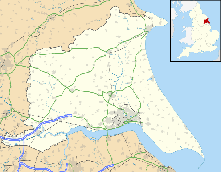
Map of the East Riding of Yorkshire, UK with the following information shown:
Equirectangular map projection on WGS 84 datum, with N/S stretched 165% Geographic limits:
|
| Date | |
| Source |
|
| Auteur | Nilfanion, created using Ordnance Survey data |
| Autorisation (Réutilisation de ce fichier) |
Ce fichier est disponible selon les termes de la licence Creative Commons Attribution – Partage dans les Mêmes Conditions 3.0 (non transposée). Attribution: Contains Ordnance Survey data © Crown copyright and database right
|
| Autres versions | File:East Riding of Yorkshire UK district map (blank).svg - Blank map |
.svg)
Historique du fichier
Cliquer sur une date et heure pour voir le fichier tel qu'il était à ce moment-là.
| Date et heure | Vignette | Dimensions | Utilisateur | Commentaire | |
|---|---|---|---|---|---|
| actuel | 26 septembre 2010 à 18:48 | | 1 425 × 1 107 (1,33 Mio) | Nilfanion (d | contributions) | {{Information |Description=Map of the East Riding of Yorkshire, UK with the following information shown: *Administrative borders *Coastline, lakes and rivers *Roads and railways *Urban areas Equirectangular map projection o |
Vous ne pouvez pas remplacer ce fichier.
Utilisations locales du fichier
La page suivante utilise ce fichier :
Utilisations du fichier sur d’autres wikis
Les autres wikis suivants utilisent ce fichier :
- Utilisation sur ar.wikipedia.org
- Utilisation sur bg.wikipedia.org
- Utilisation sur ceb.wikipedia.org
- Utilisation sur en.wikipedia.org
- Spurn
- Beverley
- East Riding of Yorkshire
- Everingham
- Goole
- Pocklington
- Bridlington
- Hornsea
- Goodmanham
- Driffield
- Wetwang
- Boothferry
- Stamford Bridge, East Riding of Yorkshire
- Bempton Cliffs
- Withernsea
- RAF Leconfield
- Fort Paull
- Market Weighton
- Hedon
- Hessle
- Millington, East Riding of Yorkshire
- Airmyn
- Flamborough
- List of civil parishes in the East Riding of Yorkshire
- Easington, East Riding of Yorkshire
- Wold Newton, East Riding of Yorkshire
- Burton Constable Hall
- Cottingham, East Riding of Yorkshire
- Arram
- Ferens Art Gallery
- Bridlington Priory
- Tibthorpe
- Wawne
- Langtoft, East Riding of Yorkshire
- Skelton, East Riding of Yorkshire
- Bilton, East Riding of Yorkshire
- Leven, East Riding of Yorkshire
- Burton Agnes
- Holme-on-Spalding-Moor
- Roos
- Middleton on the Wolds
- Howden
- Rudston
- Bishop Burton
- Sewerby
- Carnaby, East Riding of Yorkshire
- Skipsea
Voir davantage sur l’utilisation globale de ce fichier.