File:East Riding of Yorkshire UK locator map 2010.svg
Sautar la navigacion
Sautar la recèrca

Talha d'aquesta previsualizacion PNG per aquest fichièr SVG: 494 × 600 pixèls. Autras resolucions : 198 × 240 pixèls | 395 × 480 pixèls | 633 × 768 pixèls | 843 × 1 024 pixèls | 1 687 × 2 048 pixèls | 1 108 × 1 345 pixèls.
Fichièr d'origina (Fichièr SVG, resolucion de 1 108 × 1 345 pixèls, talha : 302 Ko)
Llegendes
Llegendes
Afegeix una explicació d'una línia del que representa aquest fitxer
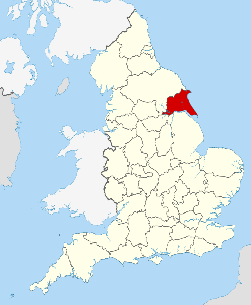
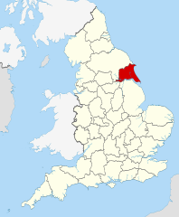
Location of the ceremonial county of the East Riding of Yorkshire
Descripcion[modificar]
| Descripcion | Location of the ceremonial county of the East Riding of Yorkshire within England. |
| Data | |
| Font |
National Geospatial-Intelligence Agency
|
| Autor | Nilfanion |
Publicat jos licéncia(s)[modificar]
Ieu, autor d'aquesta òbra, publiqui jos las licéncias seguentas:
Aqueste fichièr es jos licéncia Creative Commons licéncia generica atribucion-partiment a l'identic 3.0
- Sètz liure :
- de partejar – de copiar, distribuir e transmetre aquesta òbra
- d'adaptar – d'adaptar aquesta òbra
- Jos las condicions seguentas :
- atribucion – Vos cal atribuir aquesta òbra amb lo biais especificat per l'autor o lo concedent (mas pas dins un sens que suggerís que vos apròvan o qu'apròvan l'utilizacion d'aquesta òbra).
- partiment a l'identic – Se modificatz, transformatz, o vos basatz sus aquesta òbra, vos cal distribuir l'òbra resultanta jos la meteissa licéncia o una licéncia similara a aquesta.

|
Avètz la permission de copiar, distribuir e modificar aqueste document segon los tèrmes de la Licéncia de documentacion liura GNU, version 1.2 o mai recenta publicada per la Free Software Foundation; sens seccions inalterablas, sens tèxte de primièra pagina de tempa e sens tèxte de darrièra pagina de tempa. Un exemplar de la licéncia es inclús dins la seccion intitulada GNU Free Documentation License. |
Podètz causir la licéncia que volètz.

|
This is one of the images forming part of the Valued image set: Locator maps of the Ceremonial counties of England on Wikimedia Commons. The image set has been assessed under the valued image set criteria and is considered the most valued set on Commons within the scope:
Locator maps of the Ceremonial counties of England
You can see its nomination at Commons:Valued image candidates/Locator maps of English ceremonial counties. |
Istoric del fichièr
Clicar sus una data e una ora per veire lo fichièr tal coma èra a aqueste moment
| Data e ora | Miniatura | Dimensions | Utilizaire | Comentari | |
|---|---|---|---|---|---|
| actual | 23 novembre de 2010 a 22.35 | | 1 108 × 1 345 (302 Ko) | Nilfanion (discussion | contribucions) | == Summary == {{Information |Description=Location of the ceremonial county of the East Riding of Yorkshire within England. |Source=Ordnance Survey [https://www.ordnancesurvey.co.uk/opendatadownload/prod |
Podètz pas remplaçar aqueste fichièr.
Paginas que contenon lo fichièr
Las paginas çaijós compòrtan aqueste imatge :
- Valued image set: Locator maps of the Ceremonial counties of England
- Commons:Valued image candidates/Locator maps of English ceremonial counties
- Category:Archaeological sites in the East Riding of Yorkshire
- Category:Births in the East Riding of Yorkshire
- Category:East Riding of Yorkshire
- Category:East Riding of Yorkshire in the 1980s
- Category:Meadows in the East Riding of Yorkshire
- Category:People of the East Riding of Yorkshire
- Category:Rivers of the East Riding of Yorkshire
- Category:Views of the East Riding of Yorkshire
- Category:Villages in the East Riding of Yorkshire
- Category:Windmills in the East Riding of Yorkshire
Usatge global del fichièr
Los autres wikis seguents utilizan aqueste imatge :
- Utilizacion sus af.wikipedia.org
- Utilizacion sus ar.wikipedia.org
- Utilizacion sus ast.wikipedia.org
- Utilizacion sus be-tarask.wikipedia.org
- Utilizacion sus bg.wikipedia.org
- Utilizacion sus bn.wikipedia.org
- Utilizacion sus ca.wikipedia.org
- Utilizacion sus ceb.wikipedia.org
- Utilizacion sus cs.wikipedia.org
- Utilizacion sus dag.wikipedia.org
- Utilizacion sus da.wikipedia.org
- Utilizacion sus en.wikipedia.org
- East Riding of Yorkshire
- East Yorkshire (district)
- Boothferry
- Holderness (borough)
- East Yorkshire Borough of Beverley
- Howdenshire
- Millington, East Riding of Yorkshire
- Bishop Wilton Wold
- Arram
- Skelton, East Riding of Yorkshire
- Bilton, East Riding of Yorkshire
- Middleton on the Wolds
- Rawcliffe, East Riding of Yorkshire
- Rawcliffe Bridge
- Youlthorpe
- Tickton
- North Humberside
- Beeford
- Beswick, East Riding of Yorkshire
- Bewholme
- Boynton, East Riding of Yorkshire
- Broomfleet
- Template:EastRiding-geo-stub
- Boothferry (district)
- Sigglesthorne
- Burnby Hall Gardens
- Emmotland
- Fisholme
- Gembling
- Knedlington
- Faxfleet
- Skirpenbeck
- Holme on the Wolds
- Ravenser Odd
- Willitoft
- Ravenspurn
- Wyton, East Riding of Yorkshire
- Painsthorpe
Veire l'utilizacion globala d'aqueste fichièr.