File:Elevated view across Stillwell Avenue showing control tower and storefronts. Looking east by northeast. - Stillwell Avenue Station, Intersection of Stillwell and Surf Avenues, Brooklyn, HAER NY-325-5.tif
Jump to navigation
Jump to search

Size of this JPG preview of this TIF file: 750 × 600 pixels. Other resolutions: 300 × 240 pixels | 600 × 480 pixels | 960 × 768 pixels | 1,280 × 1,024 pixels | 2,560 × 2,048 pixels | 5,275 × 4,219 pixels.
Original file (5,275 × 4,219 pixels, file size: 21.23 MB, MIME type: image/tiff)
Captions
Captions
Add a one-line explanation of what this file represents
Summary[edit]
| Elevated view across Stillwell Avenue showing control tower and storefronts. Looking east by northeast. - Stillwell Avenue Station, Intersection of Stillwell and Surf Avenues, Brooklyn, Kings County, NY | ||||
|---|---|---|---|---|
| Photographer |
Rob Tucher |
|||
| Title |
Elevated view across Stillwell Avenue showing control tower and storefronts. Looking east by northeast. - Stillwell Avenue Station, Intersection of Stillwell and Surf Avenues, Brooklyn, Kings County, NY |
|||
| Depicted place | New York; Kings County; Brooklyn | |||
| Date | Documentation compiled after 1968 | |||
| Dimensions | height: 4 in (10.1 cm); width: 5 in (12.7 cm) | |||
| Accession number |
HAER NY-325-5 |
|||
| Credit line |
|
|||
| Notes |
|
|||
| Source |
|
|||
| Permission (Reusing this file) |
|
|||


| Object location | | View this and other nearby images on: OpenStreetMap |
|---|
File history
Click on a date/time to view the file as it appeared at that time.
| Date/Time | Thumbnail | Dimensions | User | Comment | |
|---|---|---|---|---|---|
| current | 11:47, 1 August 2014 | 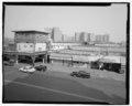 | 5,275 × 4,219 (21.23 MB) | Fæ (talk | contribs) | GWToolset: Creating mediafile for Fæ. HABS 1 Aug (2301:2600) missing |
You cannot overwrite this file.
File usage on Commons
The following page uses this file: