File:England and Wales AONBs map.svg
跳转到导航
跳转到搜索

此SVG文件的PNG预览的大小:494 × 600像素。 其他分辨率:198 × 240像素 | 395 × 480像素 | 633 × 768像素 | 844 × 1,024像素 | 1,687 × 2,048像素 | 1,648 × 2,000像素。
原始文件 (SVG文件,尺寸为1,648 × 2,000像素,文件大小:1.53 MB)
说明
说明
添加一行文字以描述该文件所表现的内容

|
本文件已被England, Northern Ireland, and Wales AONBs map.svg取代。建议您使用其他文件。请注意,删除被取代的图片需要达成一致。
|

|
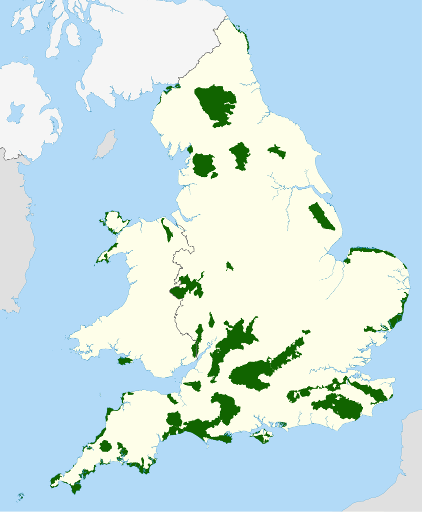
| 描述 | Map of showing all of the Area of Outstanding Natural Beauty of England and Wales |
| 日期 | |
| 来源 |
National Geospatial-Intelligence Agency
|
| 作者 | Nilfanion, using Ordnance Survey and Natural England data |
| 授权 (二次使用本文件) |
本文件采用知识共享署名-相同方式共享 3.0 未本地化版本许可协议授权。 署名: © Countryside Council for Wales. All rights reserved. Ordnance Survey Licence number 100019741 © Natural England copyright 2012. Contains Ordnance Survey data © Crown copyright and database right 2012
|
| 其他版本 | Derivative works of this file: Solway Coast AONB.png |
文件历史
点击某个日期/时间查看对应时刻的文件。
| 日期/时间 | 缩略图 | 大小 | 用户 | 备注 | |
|---|---|---|---|---|---|
| 当前 | 2012年4月15日 (日) 22:28 | | 1,648 × 2,000(1.53 MB) | Nilfanion(留言 | 贡献) | {{Information |Description=Map of showing all of the Area of Outstanding Natural Beauty of England and Wales |Source=Ordnance Survey [https://www.ordnancesurvey.co.uk/opendatadownload/produ... |
您不可以覆盖此文件。
文件用途
以下6个页面使用本文件:
全域文件用途
以下其他wiki使用此文件:
- ca.wikipedia.org上的用途
- en.wikipedia.org上的用途
- he.wikipedia.org上的用途
- is.wikipedia.org上的用途
- it.wikivoyage.org上的用途
- ja.wikipedia.org上的用途
- ko.wikipedia.org上的用途
- lt.wikipedia.org上的用途
- no.wikipedia.org上的用途
- sv.wikipedia.org上的用途
- vls.wikipedia.org上的用途
- zh.wikipedia.org上的用途