File:Eshbottom Farmhouse.jpg
Jump to navigation
Jump to search

Size of this preview: 800 × 554 pixels. Other resolutions: 320 × 222 pixels | 640 × 443 pixels | 1,024 × 709 pixels | 1,280 × 886 pixels | 2,560 × 1,773 pixels | 4,845 × 3,355 pixels.
Original file (4,845 × 3,355 pixels, file size: 2.54 MB, MIME type: image/jpeg)
Captions
Captions
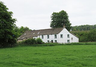
Photograph of Eshbottom Farmhouse, Coniston Cold, North Yorkshire, England
Summary
[edit]
| Description |
English: Photograph of Eshbottom Farmhouse, Coniston Cold, North Yorkshire, England |
| Date | |
| Source | https://www.geograph.org.uk/photo/7506172 |
| Author | Gordon Hatton |
| Attribution (required by the license) | Gordon Hatton / Eshbottom farmhouse / |
| Camera location | | View this and other nearby images on: OpenStreetMap |
|---|
This is a photo of listed building number 1132078. |
Licensing
[edit]

|
This image was taken from the Geograph project collection. See this photograph's page on the Geograph website for the photographer's contact details. The copyright on this image is owned by Gordon Hatton and is licensed for reuse under the Creative Commons Attribution-ShareAlike 2.0 license.
|
This file is licensed under the Creative Commons Attribution-Share Alike 2.0 Generic license.
Attribution: Gordon Hatton
- You are free:
- to share – to copy, distribute and transmit the work
- to remix – to adapt the work
- Under the following conditions:
- attribution – You must give appropriate credit, provide a link to the license, and indicate if changes were made. You may do so in any reasonable manner, but not in any way that suggests the licensor endorses you or your use.
- share alike – If you remix, transform, or build upon the material, you must distribute your contributions under the same or compatible license as the original.
File history
Click on a date/time to view the file as it appeared at that time.
| Date/Time | Thumbnail | Dimensions | User | Comment | |
|---|---|---|---|---|---|
| current | 21:14, 17 June 2024 | | 4,845 × 3,355 (2.54 MB) | Bjh21 (talk | contribs) | Replaced with the highest-resolution version that Geograph currently has |
| 17:28, 12 June 2024 |  | 1,024 × 709 (169 KB) | Peter I. Vardy (talk | contribs) | Uploaded a work by Gordon Hatton from https://www.geograph.org.uk/photo/7506172 with UploadWizard |
You cannot overwrite this file.
File usage on Commons
There are no pages that use this file.
File usage on other wikis
The following other wikis use this file:
- Usage on en.wikipedia.org
- Usage on www.wikidata.org