File:Europe. LOC 2004621193.jpg
Jump to navigation
Jump to search

Size of this preview: 508 × 600 pixels. Other resolutions: 203 × 240 pixels | 407 × 480 pixels | 650 × 768 pixels | 867 × 1,024 pixels | 1,735 × 2,048 pixels | 9,935 × 11,729 pixels.
Original file (9,935 × 11,729 pixels, file size: 12.42 MB, MIME type: image/jpeg)
Captions
Captions
Add a one-line explanation of what this file represents
Summary
[edit]| Warning | The original file is very high-resolution. It might not load properly or could cause your browser to freeze when opened at full size. |
|---|
| Description |
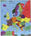
English: Wall map showing countries, capital cities, and other major cities. "803088AI (C00968) 11-04." Includes note. Available also through the Library of Congress Web site as a raster image. |
||
| Title | Europe. | ||
| Shelf ID | G5700 2004 .U4 | ||
| Date | |||
| Source | https://www.loc.gov/item/2004621193/ | ||
| Author | United States. Central Intelligence Agency | ||
| Permission (Reusing this file) |
|
||
| Other versions |
|
||
| Location | Europe | ||
| Part of | American Memory · General Maps · Catalog · Geography And Map Division | ||
| Subject | Europe · Maps · Administrative And Political Divisions |

Licensing
[edit]
| This image is a work of a Central Intelligence Agency employee, taken or made as part of that person's official duties. As a Work of the United States Government, this image or media is in the public domain in the United States.
|

|
File history
Click on a date/time to view the file as it appeared at that time.
| Date/Time | Thumbnail | Dimensions | User | Comment | |
|---|---|---|---|---|---|
| current | 20:29, 1 June 2018 | | 9,935 × 11,729 (12.42 MB) | Fæ (talk | contribs) | LOC Maps https://www.loc.gov/item/2004621193/ #1799 |
You cannot overwrite this file.
File usage on Commons
The following page uses this file: