File:Europe 814.jpg
跳转到导航
跳转到搜索
本预览的尺寸:761 × 600像素。 其他分辨率:305 × 240像素 | 609 × 480像素 | 975 × 768像素 | 1,280 × 1,009像素 | 1,477 × 1,164像素。
原始文件 (1,477 × 1,164像素,文件大小:302 KB,MIME类型:image/jpeg)
说明
说明
添加一行文字以描述该文件所表现的内容

|
本文件已被Europe 814.png取代。建议您使用其他文件。请注意,删除被取代的图片需要达成一致。
|

|
摘要
[编辑].jpg)
_en.png)
.png)
.jpg)
许可协议
[编辑]
|
|
 | |
 |
文件历史
点击某个日期/时间查看对应时刻的文件。
| 日期/时间 | 缩略图 | 大小 | 用户 | 备注 | |
|---|---|---|---|---|---|
| 当前 | 2015年9月22日 (二) 10:28 | | 1,477 × 1,164(302 KB) | BosnaSRB RS(留言 | 贡献) | Reverted to version as of 18:16, 10 April 2006 Best quality |
| 2012年12月29日 (六) 18:06 |  | 1,349 × 1,037(1.31 MB) | Hel-hama(留言 | 贡献) | quality of colours improved | |
| 2010年12月17日 (五) 03:43 |  | 1,404 × 1,083(1.55 MB) | Alphathon(留言 | 贡献) | Cleaned up a bit | |
| 2010年7月19日 (一) 23:19 |  | 1,402 × 1,089(462 KB) | Beao(留言 | 贡献) | Removed border. | |
| 2009年4月28日 (二) 16:19 |  | 1,477 × 1,164(374 KB) | Alex:D(留言 | 贡献) | whitened | |
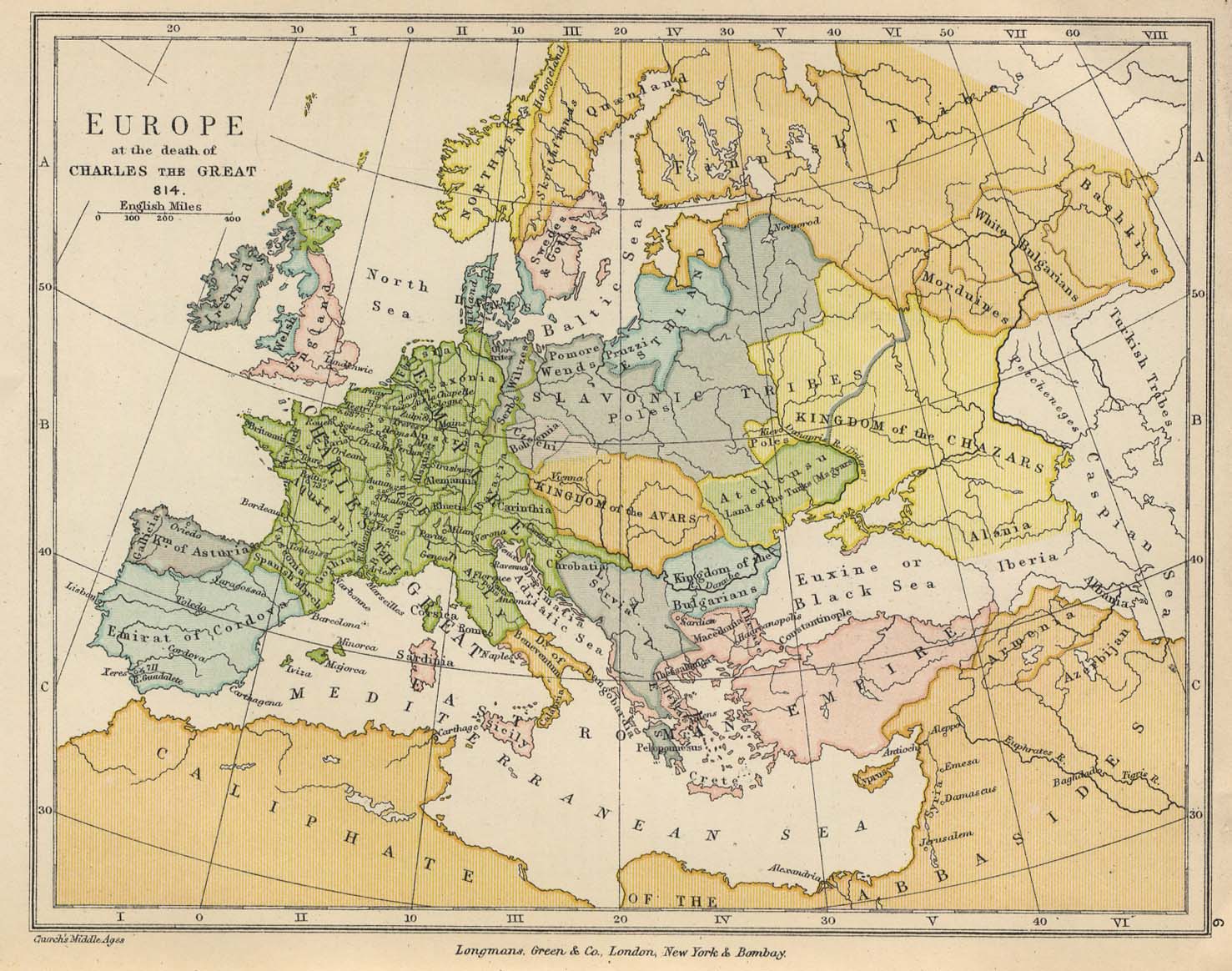
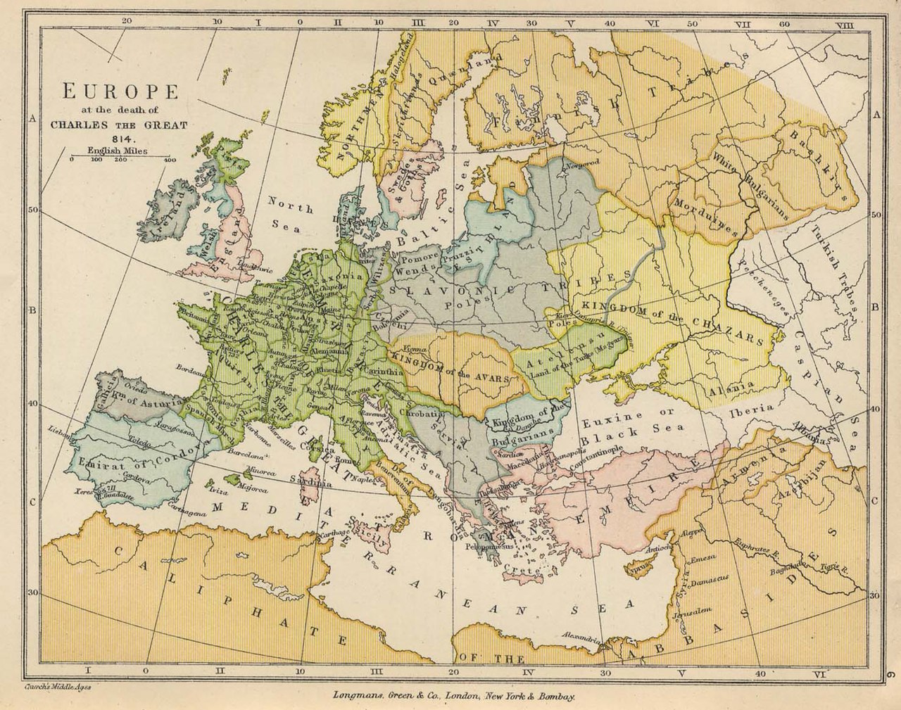
| 2006年4月10日 (一) 18:16 |  | 1,477 × 1,164(302 KB) | CommonismNow(留言 | 贡献) | Europe 814 *From The Public Schools Historical Atlas edited by C. Colbeck, published by Longmans, Green, and Co. 1905. ==Original authors== * Source: German Wikipedia * Upload Tool Operator: User:Flominator * Image cont |
您不可以覆盖此文件。
文件用途
以下13个页面使用本文件:
全域文件用途
以下其他wiki使用此文件:
- af.wikipedia.org上的用途
- ang.wikipedia.org上的用途
- ar.wikipedia.org上的用途
- ast.wikipedia.org上的用途
- bat-smg.wikipedia.org上的用途
- ba.wikipedia.org上的用途
- be.wikipedia.org上的用途
- ca.wikipedia.org上的用途
- ce.wikipedia.org上的用途
- ckb.wikipedia.org上的用途
- cs.wikipedia.org上的用途
- cv.wikipedia.org上的用途
- cy.wikipedia.org上的用途
- da.wikipedia.org上的用途
- de.wikipedia.org上的用途
- de.wikiversity.org上的用途
- de.wiktionary.org上的用途
- dsb.wikipedia.org上的用途
- el.wikipedia.org上的用途
- en.wikipedia.org上的用途
- Talk:Ab urbe condita
- Talk:Bohemia
- Talk:Battle of Marathon
- Talk:Stab-in-the-back myth
- Talk:East Germany
- Talk:German Empire
- Talk:Great Fire of London
- Talk:History of Spain
- Talk:Huns
- Talk:Hellenic Greece
- Talk:History of Germany
- Talk:The Holocaust
- Talk:History of the Republic of Turkey
- Talk:Prince-elector
- Talk:History of the Netherlands
- Talk:Hanseatic League
- Talk:History of Poland
查看此文件的更多全域用途。
元数据
分类:
- Maps of 9th-century Europe
- Maps showing history of the Early Middle Ages
- Public Schools Historical Atlas by C. Colbeck (1905)
- Maps of White Serbia
- Maps of Eurasian Avars
- Avar Khaganate
- Maps of the Khazars
- Maps of Slavic tribes
- Old maps of the Carolingian Empire
- Carolingian Empire in the 810s
- Maps of the history of Chuvashia
- Maps of the history of Tatarstan
- Maps of the history of Bashkortostan
- Maps of the history of Mordovia
- Maps of Khazar Khaganate
- Poland in the 9th century
- Pomerania in the 9th century
- Kvenland
- Maps of the Bashkirs