File:Europe in 1923.jpg

Fitxer original (7.097 × 5.456 píxels, mida del fitxer: 6,97 Mo, tipus MIME: image/jpeg)
Llegendes
Llegendes
Resum
[modifica]| Descripció |
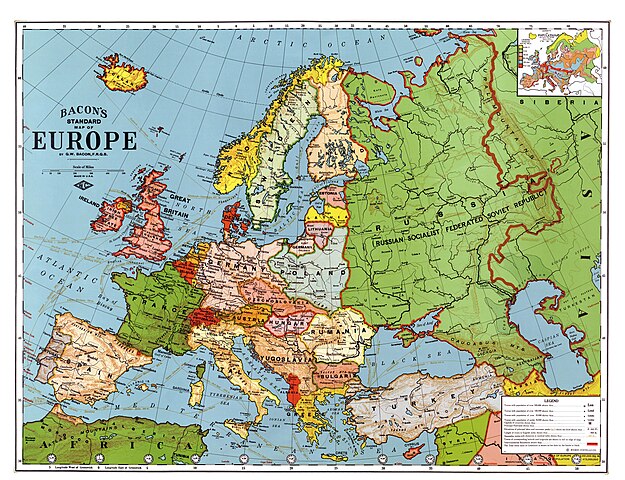
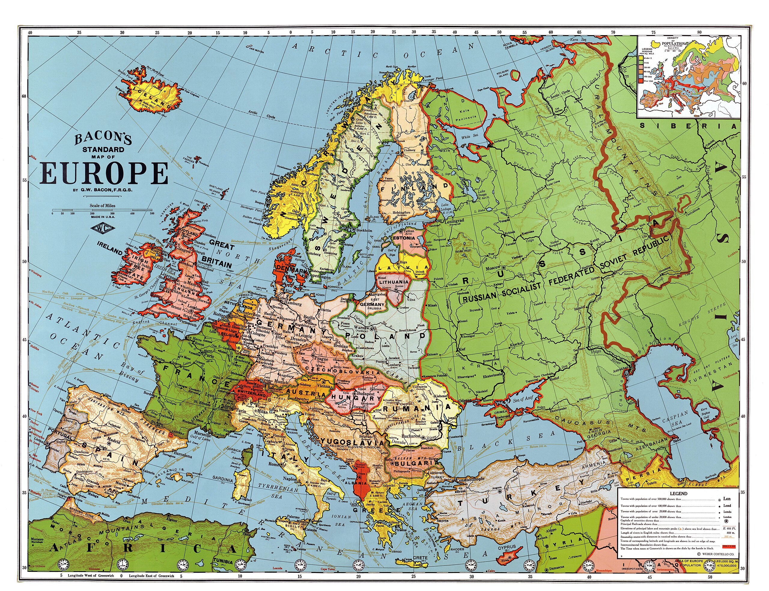
English: Bacon's standard map of Europe, 1923. Relief shown by hachures and spot heights. Shows steamship routes and time zones. Published by Weber Costello Co., 84 x 111 cm. Scale 1:5,500,000 (W 52°--E 80°/N 60°--N 30°).
Français : Carte "standard" de l'Europe au 1/5 500 000, par Bacon, 1923. Les reliefs sont donnés par des hachures et des indications de certaines altitudes. Les principales routes maritimes sont indiquées, ainsi que les fuseaŭx horaires. Publié par la compagnie Weber Costello, 84 x 111 cm.
Italiano: Carta geografica generale dell'Europa in lingua inglese (84 x 111 cm, scala 1:5 500 000), realizzata da G. W. Bacon e pubblicata da Weber Costello Co. nel 1923
Polski: Mapa Europy w skali 1:5500000 wydawnictwa Weber Costello Co. Uwzględnia granice z 1923 r. oraz m.in. szlaki morskie i strefy czasowe.
Türkçe: 1923 yılındaki ülke sınırlarını gösteren Avrupa haritası. Yükseltiler tarama çizgiler ve belli noktaların yükseklikleri ile belli edilmiştir. Saat dilimleri ve gemi yolları da gösterilmiştir. |
||
| Data | després de 1924 | ||
| Font |
|
||
| Creador |
Bacon, George Washington (1830-1921) |
||
| Georeferencing | If inappropriate please set warp_status = skip to hide. | ||
| Altres versions |


| Això és una imatge retocada, cosa que vol dir que ha estat alterada digitalment de la seva versió original. Modificacions: Contrast enhanced, colors corrected, halves united. Modificacions fetes per Alex:D.L'original es pot trobar aquí.
|
|

Aquesta imatge va ser escollida imatge del dia el 27 May 2010. La seva descripció va ser la següent: English: George Washington Bacon's standard map of Europe, 1923. Relief shown by hachures and spot heights. Shows steamship routes and time zones. Published by Weber Costello Co., 84 × 111 cm. Scale 1:5,500,000 (W 52°--E 80°/N 60°--N 30°). Altres idiomes:
Čeština: Standardní mapa Evropy od George Washingtona Bacona z roku 1923; reliéf je značen šrafurou a kótami, vyznačeny jsou tratě parníků a časová pásma; měřítko 1 : 5 500 000, 84 × 111 cm Dansk: George Washington Bacons standardkort over Europa fra 1923. Topografien er vist med skraveringer, og punkter viser bjergtoppe. Kortet viser også skibsruter og tidszoner. Udgivet af Weber Costello Co, 88 × 111 cm. Målestok 1:5.500.000 (52°V - 80°Ø / 60°N - 30°N). Deutsch: George Washington Bacons Standardkarte von Europa von 1923. Die Topografie wird durch Schraffuren und Punkthöhen dargestellt. Ebenso sind Dampferrouten und Zeitzonen dargestellt. Veröffentlicht durch Weber Costello Co., 84 × 111 cm. Maßstab 1:5,500,000 (W 52°--E 80°/N 60°--N 30°). English: George Washington Bacon's standard map of Europe, 1923. Relief shown by hachures and spot heights. Shows steamship routes and time zones. Published by Weber Costello Co., 84 × 111 cm. Scale 1:5,500,000 (W 52°--E 80°/N 60°--N 30°). Español: Mapa estándar de Europa de George Washington Bacon, 1923. El relieve se muestra con líneas de sombra y puntos de altura. Incluye rutas de barcos a vapor y zonas horarias. Publicado por Weber Costello Co., 84×111 cm. Escala 1:5.500.000 (52° O–80° E/60° N–30° N). Français : Carte "standard" de l'Europe au 1/5 500 000, par Bacon, 1923. Les reliefs sont donnés par des hachures et des indications de certaines altitudes. Les principales routes maritimes sont indiquées, ainsi que les fuseaux horaires. Publié par la compagnie Weber Costello, 84 x 111 cm. Italiano: Carta geografica generale dell'Europa in lingua inglese (84 x 111 cm, scala 1:5 500 000), realizzata da G. W. Bacon e pubblicata da Weber Costello Co. nel 1923 Magyar: Európa-térkép 1923-ból, időzónákkal és hajóutakkal Nederlands: Standaardkaart van Europa uit 1923 van de Britse uitgever George Washington Bacon (1830-1922). De topografie wordt weergegeven door arceringen en hoogtepunten. Ook zijn stoombootroutes en tijdzones afgebeeld. Uitgegeven door Weber Costello Co. Afmeting: 84 × 111 cm. Schaal 1:5.500.000 (W 52° - E 80°/N 60° - N 30°). Português: Mapa da Europa publicado em 1923. Беларуская (тарашкевіца): Агульная мапа Эўропы Джорджа Вашынгтона Бэкана 1923 году. Выдадзена Weber Costello Co., 84 × 111 см. Маштаб 1:5 500 000 (З 52°—У 80°/П 60°—П 30°). Македонски: Бејконова стандардна карта на Европа на (1923). Релјефот е изразен со сенчање и коти. Прикажани се парабродски маршрути и часовни зони. Издавач: Weber Costello Co., 84 × 111 cm. Размер: 1:5.500.000 (З 52°--И 80°/С 60°--С 30°). Українська: Карта Європи 1923 року англійського видавця книг і мап Джорджа Вашінгтона Бейкена. Зображено рельєф, пароплавні маршрути, часові пояси. Надруковано Weber Costello Co., 84 × 111 см. Масштаб 1:5 500 000 (З 52°— С 80°/П 60° — П 30°). বাংলা : ১৯২৩ সালে জর্জ ওয়াশিংটন বেকন কর্তৃক অঙ্কিত ইউরোপের মানচিত্র। কোনো স্থানের উচ্চতা প্রদর্শিত হয়েছে, সেই সাথে বাষ্পীয় ইঞ্জিন চালিত জাহাজের চলাচলের পথ ও সময়স্থানও সূচিত হয়েছে। এটি প্রকাশ করেছিলো ওয়েবার ক্যাসটেল্লো কোম্পানি। প্রকাশের সময় এর আকৃতি ছিলো ৮৪ × ১১১ সেন্টিমিটার। স্কেল ১:৫,৫০০,০০০ (প্রদর্শিত স্থান: ৫২° পশ্চিম - ৮০° পূর্ব ও ৬০° উত্তর থেকে ৩০° উত্তর)। 한국어: 1923년의 유럽 지도. 日本語: 「ベーコンの標準ヨーロッパ地図」縮尺 1 : 5,500,000。1923年アメリカ製。 中文: 1923年版本的欧洲地图,比例尺为1:5,500,000,尺寸为84 x 111 cm 中文(繁體): 1923年版本的歐洲地圖,比例尺為1:5,500,000,尺寸為84 x 111 cm。 |
Llicència
[modifica]
|
Aquest material està en domini públic als Estats Units i als altres països on el dret d'autor s'estén per 70 anys (o menys) després de la mort de l'autor.
| |
| Aquest fitxer està identificat com a lliure de restriccions conegudes sota la llei de drets d'autor, inclosos els drets veïns. | |
Aquest fitxer és en el domini públic en els Estats Units. Això és aplicable a obres dels EUA on el copyright ha expirat, sovint perquè la seva primera publicació va ser abans de l'1 de gener de 1929. Vegeu aquesta pàgina per a més detalls.
|
 | |
 |
Podria ser que aquesta imatge no estigui en el domini públic fora dels Estats Units (especialment on no s'aplica la regla del termini més curt per obres dels EUA, com Canada, la Xina continental (no a Hong Kong ni Macau), Alemanya, Mèxic i Suïssa). El creador i any de publicació són informació essencial i s'han de proporcionar. Vegeu Viquipèdia:Drets d'autor per a més detalls.
|
_en.png)
.png)
.jpg)
Historial del fitxer
Cliqueu una data/hora per veure el fitxer tal com era aleshores.
| Data/hora | Miniatura | Dimensions | Usuari/a | Comentari | |
|---|---|---|---|---|---|
| actual | 14:15, 25 gen 2013 | | 7.097 × 5.456 (6,97 Mo) | Slick-o-bot (discussió | contribucions) | Bot: convert to a non-interlaced jpeg (see bug #17645) |
| 06:58, 1 maig 2009 |  | 7.097 × 5.456 (6,54 Mo) | Alex:D (discussió | contribucions) | {{Information |Description= {{en|Bacon's standard map of Europe, 1923. Published by Weber Costello Co., 84 x 111 cm. Relief shown by hachures and spot heights. Shows steamship routes and time zones. Scale 1:5,500,000 (W 52°--E 80°/N 60°--N 30°).} |
No podeu sobreescriure aquest fitxer.
Ús del fitxer
Les 55 pàgines següents utilitzen aquest fitxer:
- User:Fæ/LOC maps/wikimedia usage
- User:Platonides/POTD
- User talk:Alex:D/3
- Commons:Featured picture candidates/File:Map of Europe, 1921.jpg
- Commons:Featured picture candidates/Log/May 2009
- Commons:Featured pictures/Non-photographic media/Maps
- Commons:Featured pictures/chronological/2009-A
- Commons:Picture of the Year/2009/Galleries/2009-A
- Commons:Picture of the Year/2009/Galleries/All
- Commons:Picture of the Year/2009/Galleries/Diagrams
- Commons:Picture of the Year/2009/Galleries/Index/6
- Commons:Picture of the Year/2009/Galleries/Index/Diagrams
- Commons:Picture of the Year/2009/Galleries/Table/200905
- Commons:Picture of the Year/2009/R1/File:Map of Europe, 1923.jpg
- Commons:Picture of the Year/2009/Results/R1/ALL/Table
- Commons:Picture of the Year/2009/Results/R1/Diagrams
- Commons:Picture of the Year/2009/Results/R1/Diagrams/Table
- Commons:Potd/2010-05 (da)
- Commons:Potd/2010-05 (de)
- Commons:Potd/2010-05 (nl)
- Commons:Potd/2010-05 (pt)
- File:Ildefonso Puigdengolas (Albero y Segovia 21-07-1936) en Alcalá de Henares.png
- File:Lithuania, Latvia and Estonia (1923).JPG
- File:Map of Density of Population of Europe, 1923.jpg
- File:Map of Europe, 1923.jpg (fitxer redirigit)
- Commons:Picture of the Year/2009/Galleries/Diagrams
- Commons:Picture of the Year/2009/Galleries/All
- Commons:Picture of the Year/2009/Galleries/2009-A
- Commons:Picture of the Year/2009/Galleries/Index/6
- Commons:Picture of the Year/2009/R1/File:Map of Europe, 1923.jpg
- Commons:Picture of the Year/2009/Galleries/Index/Diagrams
- Commons:Picture of the Year/2009/Results/R1/Diagrams
- User talk:Alex:D/3
- Template:Potd/2010-05
- Template:Potd/2010-05-27
- Template:Potd/2010-05-27 (be-tarask)
- Template:Potd/2010-05-27 (bn)
- Template:Potd/2010-05-27 (cs)
- Template:Potd/2010-05-27 (da)
- Template:Potd/2010-05-27 (de)
- Template:Potd/2010-05-27 (en)
- Template:Potd/2010-05-27 (es)
- Template:Potd/2010-05-27 (fr)
- Template:Potd/2010-05-27 (hu)
- Template:Potd/2010-05-27 (it)
- Template:Potd/2010-05-27 (ja)
- Template:Potd/2010-05-27 (ko)
- Template:Potd/2010-05-27 (mk)
- Template:Potd/2010-05-27 (nl)
- Template:Potd/2010-05-27 (pt)
- Template:Potd/2010-05-27 (uk)
- Template:Potd/2010-05-27 (zh-hans)
- Template:Potd/2010-05-27 (zh-hant)
- Template:Potd/2010-05 (zh-hans)
- Category:Interwar period
_en_Alcal%C3%A1_de_Henares.png)
.JPG)
Ús global del fitxer
Utilització d'aquest fitxer en altres wikis:
- Utilització a af.wikipedia.org
- Utilització a ar.wikipedia.org
- Utilització a ast.wikipedia.org
- Utilització a ba.wikipedia.org
- Utilització a bg.wikipedia.org
- Utilització a bn.wikipedia.org
- Utilització a bs.wikipedia.org
- Utilització a crh.wikipedia.org
- Utilització a cs.wikipedia.org
- Utilització a cv.wikipedia.org
- Utilització a cy.wikipedia.org
- Utilització a da.wikipedia.org
- Utilització a de.wikipedia.org
- Utilització a en.wikipedia.org
- Russian Civil War
- Treaty of Brest-Litovsk
- Interwar period
- User talk:Alex:D
- Wikipedia:Featured pictures/Diagrams, drawings, and maps/Maps
- Wikipedia:WikiProject Military history/Showcase
- Wikipedia:WikiProject Military history/Showcase/FP
- Wikipedia:Graphics Lab/Map workshop/Archive/Jan 2010
- User:Kazkaskazkasako/Books/History
- Revolutions of 1917–1923
- User:Dtale1984
- 1937 tour of Germany by the Duke and Duchess of Windsor
- Wikipedia:WikiProject Women in Red/Meetup/135
- User:RJMwikiboy/sandbox
- Wikipedia:Featured pictures thumbs/67
- User:Ssss2323/sandbox
- Wikipedia:Featured picture candidates/June-2020
- Wikipedia:Featured picture candidates/A map of interwar Europe, 1923
- Wikipedia:Wikipedia Signpost/2020-06-28/Featured content
- Wikipedia:Wikipedia Signpost/Single/2020-06-28
- Portal:History/Recognized content
- Wikipedia:Picture of the day/May 2022
- Template:POTD/2022-05-09
- Wikipedia:Main Page history/2022 May 9
- Wikipedia:Main Page history/2022 May 9b
- User talk:TheFreeWorld/Archive 1
- User:Falcaorib/Europe
- Utilització a en.wikibooks.org
- Utilització a eo.wikiquote.org
- Utilització a es.wikipedia.org
- Utilització a es.wikibooks.org
- Utilització a et.wikipedia.org
Vegeu més usos globals d'aquest fitxer.