File:Europe map Napoleon 1811.png
Salta a la navegació
Salta a la cerca
No hi ha cap versió amb una resolució més gran.
Europe_map_Napoleon_1811.png (415 × 397 píxels, mida del fitxer: 62 Ko, tipus MIME: image/png)
Llegendes
Llegendes
Afegeix una explicació d'una línia del que representa aquest fitxer


|
File:Europe map Napoleon 1811.svg és una versió vectorial (SVG) d'aquest fitxer. En cas de ser millor, hauria de ser emprada en lloc d'aquesta imatge tramada.
File:Europe map Napoleon 1811.png → File:Europe map Napoleon 1811.svg
Per a més informació pel que fa als gràfics vectorials, llegiu la transició a SVG en Commons. També hi ha informació quant a la compatibilitat del MediaWiki amb les imatges SVG. |
 |
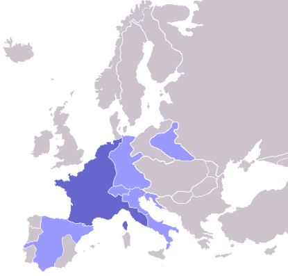
Map of the w:First French Empire and satellite states, with w:1811 borders. Created by User:OwenBlacker from Image:Europe blank map.png, therefore they are the source.
| Jo, el titular del copyright d'aquesta obra, l'allibero al domini públic. Això s'aplica a tot el món. En alguns països això pot no ser legalment possible, en tal cas: Jo faig concessió a tothom del dret d'usar aquesta obra per a qualsevol propòsit, sense cap condició llevat d'aquelles requerides per la llei. |
derivative works
[modifica]
Derivative works of this file: Europe map Napoleon 1811.svg
Historial del fitxer
Cliqueu una data/hora per veure el fitxer tal com era aleshores.
| Data/hora | Miniatura | Dimensions | Usuari/a | Comentari | |
|---|---|---|---|---|---|
| actual | 08:06, 11 oct 2022 | | 415 × 397 (62 Ko) | Рагин1987 (discussió | contribucions) | Extended map |
| 13:01, 23 jul 2020 |  | 415 × 422 (13 Ko) | Leonel Sohns (discussió | contribucions) | Reverted to version as of 00:53, 16 October 2006 (UTC) | |
| 13:01, 23 jul 2020 |  | 415 × 422 (11 Ko) | Leonel Sohns (discussió | contribucions) | Recovered old version from archive.org | |
| 00:53, 16 oct 2006 |  | 415 × 422 (13 Ko) | Deltabeignet (discussió | contribucions) | Corrected status of Illyrian provinces. | |
| 00:51, 21 ago 2005 |  | 415 × 422 (11 Ko) | OwenBlacker (discussió | contribucions) | Map of the w:First French Empire and satellite states, with w:1811 borders. Created by User:OwenBlacker from Image:Europe blank map.png {{GFDL}} {{cc-by-sa-2.0-uk}} |
No podeu sobreescriure aquest fitxer.
Ús del fitxer
Les 14 pàgines següents utilitzen aquest fitxer:
- Atlas of Belgium
- Atlas of European history
- Atlas of France
- Atlas of Galicia
- Atlas of Italy
- Atlas of Luxembourg
- Atlas of Spain
- Atlas of the early modern age
- Napoléon Bonaparte
- User:Magog the Ogre/Maps of conflicts/2020 July
- User:Magog the Ogre/Maps of conflicts/2022 October
- User:Minorax/SVG available/2022 October 7-12
- User:Thegranddesign31415
- File:Apogée Empire Napoleon 1811.jpg
Ús global del fitxer
Utilització d'aquest fitxer en altres wikis:
- Utilització a arz.wikipedia.org
- Utilització a ast.wikipedia.org
- Utilització a ba.wikipedia.org
- Utilització a be.wikipedia.org
- Utilització a bg.wikipedia.org
- Utilització a bs.wikipedia.org
- Utilització a ca.wikipedia.org
- Utilització a cs.wikipedia.org
- Utilització a cv.wikipedia.org
- Utilització a de.wikibooks.org
- Utilització a en.wikipedia.org
- Utilització a en.wikibooks.org
- Utilització a eo.wikipedia.org
- Utilització a fi.wikipedia.org
- Cisalppinen tasavalta
- Batavian tasavalta
- Hollannin kuningaskunta
- Napolin kuningaskunta
- Helvetian tasavalta
- Ligurian tasavalta
- Varsovan herttuakunta
- Malline:Napoleonin vasallit
- Etrurian kuningaskunta
- Alban tasavalta
- Reinin liitto (1806)
- Italian tasavalta (vasalli)
- Mainzin tasavalta
- Italian kuningaskunta (Napoleon)
- Cispadaaninen tasavalta
- Westfalenin kuningaskunta
- Illyrian provinssit
- Transpadaaninen tasavalta
- Utilització a fr.wikipedia.org
- Utilització a fy.wikipedia.org
- Utilització a gl.wikipedia.org
- Utilització a he.wikipedia.org
- Utilització a hr.wikipedia.org
- Utilització a hu.wikipedia.org
- Utilització a io.wikipedia.org
Vegeu més usos globals d'aquest fitxer.