File:European Middle Neolithic.gif
Pāriet uz navigāciju
Pāriet uz meklēšanu
Šī priekšskata izmērs: 800 × 397 pikseļi. Citi izmēri: 320 × 159 pikseļi | 640 × 317 pikseļi | 1 307 × 648 pikseļi.
Sākotnējais fails (1 307 × 648 pikseļi, faila izmērs: 101 KB, MIME tips: image/gif)
Captions
Captions
Pievieno vienas rindiņas aprakstu, ko šis fails attēlo
Kopsavilkums[labot šo sadaļu]

|
File:European-middle-neolithic-en.svg is a vector version of this file. It should be used in place of this GIF file when not inferior.
File:European Middle Neolithic.gif → File:European-middle-neolithic-en.svg
For more information, see Help:SVG. |
 |
.
| Apraksts |
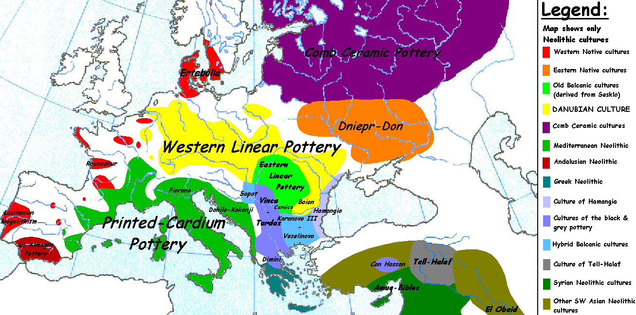
English: Map of the second half European Middle Neolithic at the apogee of Danubian and Mediterranean expansion. (The modification of the original map - Combed pottery, earlier notated as Pitted Ware, see history without respecting the color code of the legend is something that I am not fully satisfied with). |
| Datums | 2005. gada 5. aprīlis (original upload date) |
| Avots | Transferred from en.wikipedia to Commons. |
| Autors | Later versions were uploaded by Clarifer at en.wikipedia. |
| Citas versijas |
[]
|


_en.png)
.png)
.jpg)
Licence[labot šo sadaļu]
| This work has been released into the public domain by its author, Sugaar at angļu Vikipēdija. This applies worldwide. In some countries this may not be legally possible; if so: Sugaar grants anyone the right to use this work for any purpose, without any conditions, unless such conditions are required by law. |
Original upload log[labot šo sadaļu]
The original description page was here. All following user names refer to en.wikipedia.
- 2005-08-28 13:11 Clarifer 1320×663×8 (106148 bytes) Added the approximate area of the Comb Ceramic culture. Source: National Board of Antiquities, Finland. www.nba.fi
- 2005-04-05 20:12 Sugaar 1320×663×8 (103228 bytes) Map of the second half European Middle Neolithic at the apogee of Danubian and Mediterranean expansion (c. 4500-4000 BCE). Made by [[Sugaar]]. Free use authorized by the author.
Faila hronoloģija
Uzklikšķini uz datums/laiks kolonnā esošās saites, lai apskatītos, kā šis fails izskatījās tad.
| Datums/Laiks | Attēls | Izmēri | Dalībnieks | Komentārs | |
|---|---|---|---|---|---|
| tagadējais | 2014. gada 18. aprīlis, plkst. 06.43 | | 1 307 × 648 (101 KB) | Spiridon Ion Cepleanu (diskusija | devums) | Neolithic shorelines and banks, little details |
| 2010. gada 22. marts, plkst. 00.39 |  | 1 307 × 648 (101 KB) | Ras67 (diskusija | devums) | cropped | |
| 2007. gada 14. februāris, plkst. 00.50 |  | 1 320 × 663 (104 KB) | 32X (diskusija | devums) | Auf eine alte Version zurückgesetzt | |
| 2007. gada 14. februāris, plkst. 00.49 |  | 1 320 × 663 (101 KB) | 32X (diskusija | devums) | Original version by Sugaar. | |
| 2005. gada 31. decembris, plkst. 11.14 |  | 1 320 × 663 (104 KB) | Glenn (diskusija | devums) | Originally uploaded to en-wiki: Quote: "Map of the second half European Middle Neolithic at the apogee of Danubian and Mediterranean expansion (c. 4500-4000 BCE)." Upload text: "20:12, 5 April 2005 . . Sugaar . . 1320x663 (103228 bytes) (Map of the secon |
Šo failu nevar pārrakstīt.
Faila lietojums
Šo failu izmanto šajās 8 lapās:
Globālais faila lietojums
Šīs Vikipēdijas izmanto šo failu:
- Izmantojums az.wikipedia.org
- Izmantojums be.wikipedia.org
- Izmantojums bg.wikipedia.org
- Izmantojums bs.wikipedia.org
- Izmantojums ca.wikipedia.org
- Izmantojums cs.wikipedia.org
- Izmantojums da.wikipedia.org
- Izmantojums da.wikibooks.org
- Izmantojums de.wikipedia.org
- Izmantojums en.wikipedia.org
- Izmantojums et.wikipedia.org
- Izmantojums fi.wikipedia.org
- Izmantojums fi.wikibooks.org
- Izmantojums gl.wikipedia.org
- Izmantojums he.wikipedia.org
- Izmantojums hi.wikipedia.org
- Izmantojums hr.wikipedia.org
- Izmantojums hu.wikipedia.org
- Izmantojums it.wikipedia.org
Skatīt šī faila pilno globālo izmantojumu.