File:European Middle Neolithic.gif
跳至導覽
跳至搜尋
預覽大小:800 × 397 像素。 其他解析度:320 × 159 像素 | 640 × 317 像素 | 1,307 × 648 像素。
原始檔案 (1,307 × 648 像素,檔案大小:101 KB,MIME 類型:image/gif)
說明
說明
添加單行說明來描述出檔案所代表的內容
摘要
[編輯]
|
File:European-middle-neolithic-en.svg是本檔案的向量版本。 如果品質不低,就應該優先使用該檔案,而非GIF檔案。
File:European Middle Neolithic.gif → File:European-middle-neolithic-en.svg
更多資訊請參閱Help:SVG/zh。 |
 |
.
| 描述 |
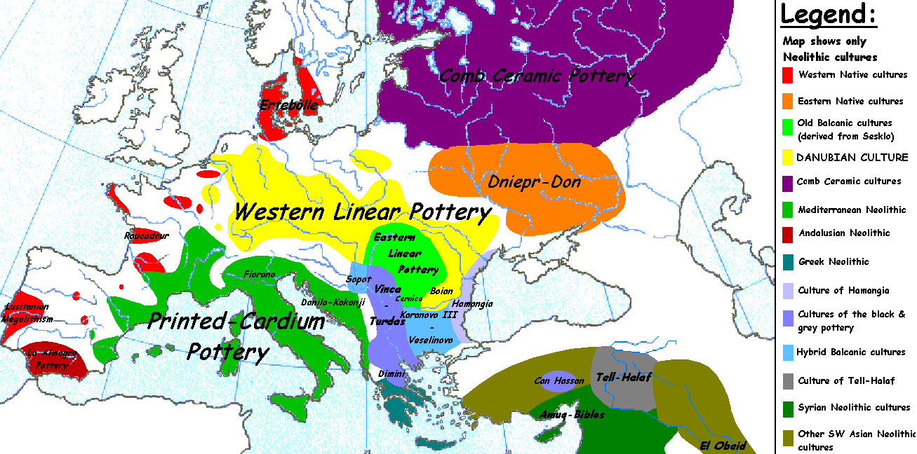
English: Map of the second half European Middle Neolithic at the apogee of Danubian and Mediterranean expansion. (The modification of the original map - Combed pottery, earlier notated as Pitted Ware, see history without respecting the color code of the legend is something that I am not fully satisfied with). |
| 日期 | 2005年4月5日 (原始上傳日期) |
| 來源 | Transferred from en.wikipedia to Commons. |
| 作者 | Later versions were uploaded by Clarifer at en.wikipedia. |
| 其他版本 |
[]
|


_en.png)
.png)
.jpg)
授權條款
[編輯]
| 此作品已由其作者,英文維基百科的Sugaar,釋出至公有領域。此授權條款在全世界均適用。 這可能在某些國家不合法,如果是的話: Sugaar授予任何人有權利使用此作品於任何用途,除受法律約束外,不受任何限制。 |
原始上傳日誌
[編輯]
The original description page was here. All following user names refer to en.wikipedia.
- 2005-08-28 13:11 Clarifer 1320×663×8 (106148 bytes) Added the approximate area of the Comb Ceramic culture. Source: National Board of Antiquities, Finland. www.nba.fi
- 2005-04-05 20:12 Sugaar 1320×663×8 (103228 bytes) Map of the second half European Middle Neolithic at the apogee of Danubian and Mediterranean expansion (c. 4500-4000 BCE). Made by [[Sugaar]]. Free use authorized by the author.
檔案歷史
點選日期/時間以檢視該時間的檔案版本。
| 日期/時間 | 縮圖 | 尺寸 | 使用者 | 備註 | |
|---|---|---|---|---|---|
| 目前 | 2014年4月18日 (五) 06:43 | | 1,307 × 648(101 KB) | Spiridon Ion Cepleanu(留言 | 貢獻) | Neolithic shorelines and banks, little details |
| 2010年3月22日 (一) 00:39 |  | 1,307 × 648(101 KB) | Ras67(留言 | 貢獻) | cropped | |
| 2007年2月14日 (三) 00:50 |  | 1,320 × 663(104 KB) | 32X(留言 | 貢獻) | Auf eine alte Version zurückgesetzt | |
| 2007年2月14日 (三) 00:49 |  | 1,320 × 663(101 KB) | 32X(留言 | 貢獻) | Original version by Sugaar. | |
| 2005年12月31日 (六) 11:14 |  | 1,320 × 663(104 KB) | Glenn(留言 | 貢獻) | Originally uploaded to en-wiki: Quote: "Map of the second half European Middle Neolithic at the apogee of Danubian and Mediterranean expansion (c. 4500-4000 BCE)." Upload text: "20:12, 5 April 2005 . . Sugaar . . 1320x663 (103228 bytes) (Map of the secon |
無法覆蓋此檔案。
檔案用途
下列8個頁面有用到此檔案:
全域檔案使用狀況
以下其他 wiki 使用了這個檔案:
- az.wikipedia.org 的使用狀況
- be.wikipedia.org 的使用狀況
- bg.wikipedia.org 的使用狀況
- bs.wikipedia.org 的使用狀況
- ca.wikipedia.org 的使用狀況
- cs.wikipedia.org 的使用狀況
- da.wikipedia.org 的使用狀況
- da.wikibooks.org 的使用狀況
- de.wikipedia.org 的使用狀況
- en.wikipedia.org 的使用狀況
- et.wikipedia.org 的使用狀況
- fi.wikipedia.org 的使用狀況
- fi.wikibooks.org 的使用狀況
- gl.wikipedia.org 的使用狀況
- he.wikipedia.org 的使用狀況
- hi.wikipedia.org 的使用狀況
- hr.wikipedia.org 的使用狀況
- hu.wikipedia.org 的使用狀況
- it.wikipedia.org 的使用狀況
檢視此檔案的更多全域使用狀況。