File:Fault Line - geograph.org.uk - 1393493.jpg
Jump to navigation
Jump to search
Size of this preview: 450 × 600 pixels. Other resolutions: 180 × 240 pixels | 480 × 640 pixels.
Original file (480 × 640 pixels, file size: 352 KB, MIME type: image/jpeg)
Captions
Captions
Add a one-line explanation of what this file represents
Summary
[edit]
| Description |
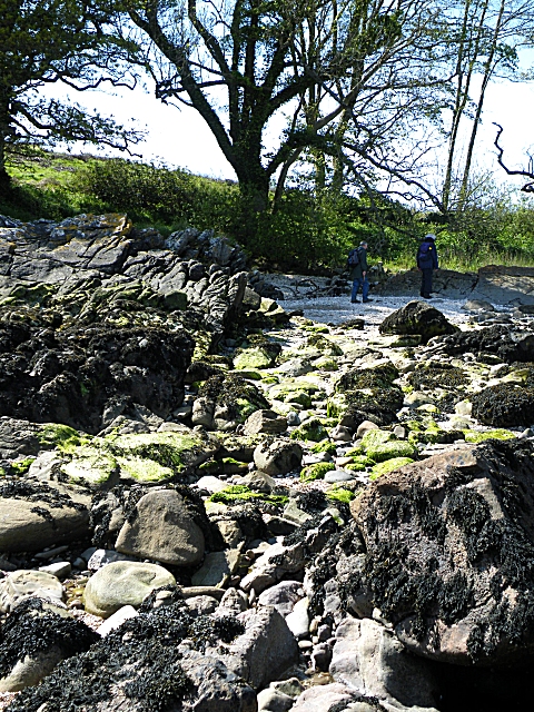
English: Fault Line Just here, the Thirlstane Sandstone of the Fell Sandstone Formation, on the left, is separated from the Arbigland Limestone Member of the Tyne Formation by a fault, which has brought the younger limestone down to the level of the older sandstone. The sharp faulted edge of the sandstone is most easily seen in the centre of this image, in line with the trunk of the tree beyond. |
| Date | |
| Source | From geograph.org.uk |
| Author | Anne Burgess |
| Attribution (required by the license) | Anne Burgess / Fault Line / |
| Camera location | | View this and other nearby images on: OpenStreetMap |
|---|
_heading:292.00&language=en)
| Object location | | View this and other nearby images on: OpenStreetMap |
|---|
_heading:292.00&language=en)
Licensing
[edit]

|
This image was taken from the Geograph project collection. See this photograph's page on the Geograph website for the photographer's contact details. The copyright on this image is owned by Anne Burgess and is licensed for reuse under the Creative Commons Attribution-ShareAlike 2.0 license.
|
This file is licensed under the Creative Commons Attribution-Share Alike 2.0 Generic license.
Attribution: Anne Burgess
- You are free:
- to share – to copy, distribute and transmit the work
- to remix – to adapt the work
- Under the following conditions:
- attribution – You must give appropriate credit, provide a link to the license, and indicate if changes were made. You may do so in any reasonable manner, but not in any way that suggests the licensor endorses you or your use.
- share alike – If you remix, transform, or build upon the material, you must distribute your contributions under the same or compatible license as the original.
File history
Click on a date/time to view the file as it appeared at that time.
| Date/Time | Thumbnail | Dimensions | User | Comment | |
|---|---|---|---|---|---|
| current | 21:53, 28 February 2011 | | 480 × 640 (352 KB) | GeographBot (talk | contribs) | == {{int:filedesc}} == {{Information |description={{en|1=Fault Line Just here, the Thirlstane Sandstone of the Fell Sandstone Formation, on the left, is separated from the Arbigland Limestone Member of the Tyne Formation by a fault, which has brought the |
You cannot overwrite this file.
File usage on Commons
There are no pages that use this file.