File:Ferry Landing, South Shields - geograph.org.uk - 572583.jpg
Jump to navigation
Jump to search
No higher resolution available.
Ferry_Landing,_South_Shields_-_geograph.org.uk_-_572583.jpg (640 × 480 pixels, file size: 114 KB, MIME type: image/jpeg)
Captions
Captions
Add a one-line explanation of what this file represents
Summary[edit]
| Description |
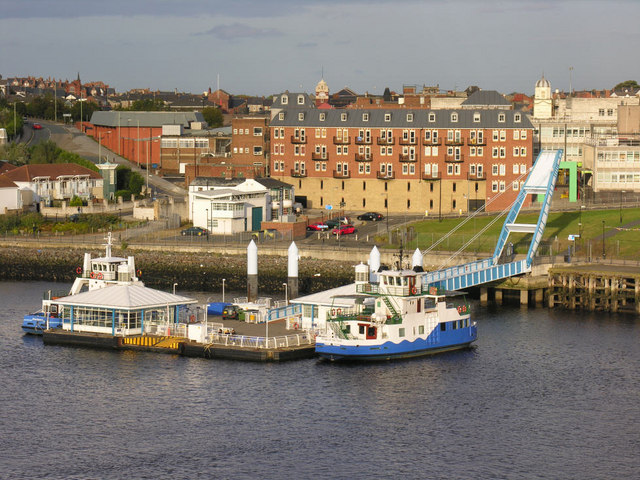
English: The South Shields side of the Shields Ferry passenger link across the mouth of the River Tyne (to North Shields), from the vantage point of a much larger ship, probably a passing DFDS cruise liner. Two ferries are berthed - Shieldsman (left) and Pride of the Tyne (right). Shieldsman is presumably laid up out of service, having been replaced by the arrival of Spirit of the Tyne in 2007. |
| Date | |
| Source | From geograph.org.uk |
| Author | George Robinson |
| Attribution (required by the license) | George Robinson / Ferry Landing, South Shields / |
| Camera location | | View this and other nearby images on: OpenStreetMap |
|---|
_heading:90.00&language=en)
| Object location | | View this and other nearby images on: OpenStreetMap |
|---|
_heading:90.00&language=en)
Licensing[edit]

|
This image was taken from the Geograph project collection. See this photograph's page on the Geograph website for the photographer's contact details. The copyright on this image is owned by George Robinson and is licensed for reuse under the Creative Commons Attribution-ShareAlike 2.0 license.
|
This file is licensed under the Creative Commons Attribution-Share Alike 2.0 Generic license.
Attribution: George Robinson
- You are free:
- to share – to copy, distribute and transmit the work
- to remix – to adapt the work
- Under the following conditions:
- attribution – You must give appropriate credit, provide a link to the license, and indicate if changes were made. You may do so in any reasonable manner, but not in any way that suggests the licensor endorses you or your use.
- share alike – If you remix, transform, or build upon the material, you must distribute your contributions under the same or compatible license as the original.
File history
Click on a date/time to view the file as it appeared at that time.
| Date/Time | Thumbnail | Dimensions | User | Comment | |
|---|---|---|---|---|---|
| current | 10:05, 6 February 2011 | | 640 × 480 (114 KB) | GeographBot (talk | contribs) | == {{int:filedesc}} == {{Information |description={{en|1=Ferry Landing, South Shields The south-side landing for the ferry service between South and North Shields.}} |date=2007-09-21 |source=From [http://www.geograph.org.uk/photo/572583 geograph.org.uk] | |
You cannot overwrite this file.
File usage on Commons
The following page uses this file:
File usage on other wikis
The following other wikis use this file:
- Usage on pl.wikipedia.org