File:Fleet 1st railway station (site), Hampshire (geograph 3775231).jpg
Jump to navigation
Jump to search

Size of this preview: 800 × 572 pixels. Other resolutions: 320 × 229 pixels | 640 × 458 pixels | 1,024 × 732 pixels.
Original file (1,024 × 732 pixels, file size: 189 KB, MIME type: image/jpeg)
Captions
Captions
Add a one-line explanation of what this file represents
Summary
[edit],_Hampshire_(geograph_3775231).jpg&action=edit§ion=1)
| Description |
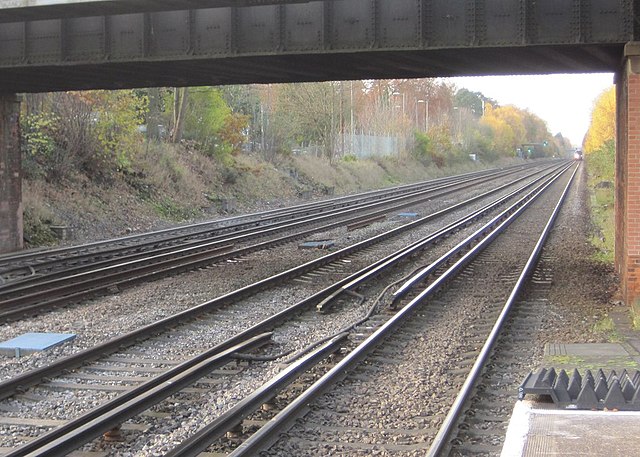
English: Fleet 1st railway station (site), Hampshire Opened as 'Fleet Pond' in 1847 by the London & South Western Railway on the line from Woking to Basingstoke, the station was renamed 'Fleet' in 1869. View west towards Winchfield and Basingstoke. This first station was closed and replaced by one immediately behind the camera position in 1904, and the line was quadrupled. No trace of the original station appears to exist. |
| Date | |
| Source | From geograph.org.uk |
| Author | Nigel Thompson |
| Permission (Reusing this file) |
Creative Commons Attribution Share-alike license 2.0 |
| Attribution (required by the license) | Nigel Thompson / Fleet 1st railway station (site), Hampshire / |
| Camera location | | View this and other nearby images on: OpenStreetMap |
|---|
,_Hampshire_(geograph_3775231).jpg¶ms=051.290466_N_-000.832043_E_globe:Earth_type:camera_source:geograph-osgb36(SU81545524)_heading:247.00&language=en)
| Object location | | View this and other nearby images on: OpenStreetMap |
|---|
,_Hampshire_(geograph_3775231).jpg¶ms=051.290300_N_-000.833050_E_globe:Earth_class:object_type:object_source:geograph-osgb36(SU81475522)_heading:247.00&language=en)
Licensing
[edit],_Hampshire_(geograph_3775231).jpg&action=edit§ion=2)

|
This image was taken from the Geograph project collection. See this photograph's page on the Geograph website for the photographer's contact details. The copyright on this image is owned by Nigel Thompson and is licensed for reuse under the Creative Commons Attribution-ShareAlike 2.0 license.
|
This file is licensed under the Creative Commons Attribution-Share Alike 2.0 Generic license.
Attribution: Nigel Thompson
- You are free:
- to share – to copy, distribute and transmit the work
- to remix – to adapt the work
- Under the following conditions:
- attribution – You must give appropriate credit, provide a link to the license, and indicate if changes were made. You may do so in any reasonable manner, but not in any way that suggests the licensor endorses you or your use.
- share alike – If you remix, transform, or build upon the material, you must distribute your contributions under the same or compatible license as the original.
File history
Click on a date/time to view the file as it appeared at that time.
| Date/Time | Thumbnail | Dimensions | User | Comment | |
|---|---|---|---|---|---|
| current | 19:14, 23 December 2019 | | 1,024 × 732 (189 KB) | Lamberhurst (talk | contribs) | Transferred from geograph.co.uk using [https://tools.wmflabs.org/geograph2commons/ geograph2commons] |
You cannot overwrite this file.
File usage on Commons
The following page uses this file:
,_Hampshire_(geograph_3775231).jpg&oldid=712854945)