File:Folly, Stewart Park - geograph.org.uk - 967541.jpg
Jump to navigation
Jump to search
No higher resolution available.
Folly,_Stewart_Park_-_geograph.org.uk_-_967541.jpg (640 × 426 pixels, file size: 292 KB, MIME type: image/jpeg)
Captions
Captions
Add a one-line explanation of what this file represents
Summary
[edit]
| Description |
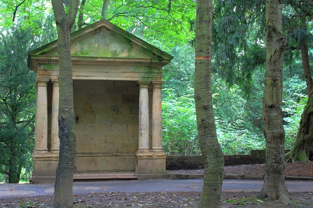
English: Folly Temple, Stewart Park A garden folly once part of the Marton Hall estate built by Teesside industrialist Henry Bolckow in 1858. In 1878 the estate passed to Bolckow's nephew Carl who managed to continue to lead an extravagant lifestyle despite the boom years of the iron industry being over. By 1907 the hall was empty, all fixtures being sold to pay off his debts. Apart from the billeting of troops during WW1 it was never lived in again. The estate was brought in 1925 by Thomas J Stewart who presented it to Middlesbrough as a park. The hall itself destroyed by fire in 1960. A few stoneworks remain. |
| Date | |
| Source | From geograph.org.uk |
| Author | Mick Garratt |
| Attribution (required by the license) | Mick Garratt / Folly, Stewart Park / |
| Camera location | | View this and other nearby images on: OpenStreetMap |
|---|
_heading:337.00&language=en)
| Object location | | View this and other nearby images on: OpenStreetMap |
|---|
_heading:337.00&language=en)
Licensing
[edit]

|
This image was taken from the Geograph project collection. See this photograph's page on the Geograph website for the photographer's contact details. The copyright on this image is owned by Mick Garratt and is licensed for reuse under the Creative Commons Attribution-ShareAlike 2.0 license.
|
This file is licensed under the Creative Commons Attribution-Share Alike 2.0 Generic license.
Attribution: Mick Garratt
- You are free:
- to share – to copy, distribute and transmit the work
- to remix – to adapt the work
- Under the following conditions:
- attribution – You must give appropriate credit, provide a link to the license, and indicate if changes were made. You may do so in any reasonable manner, but not in any way that suggests the licensor endorses you or your use.
- share alike – If you remix, transform, or build upon the material, you must distribute your contributions under the same or compatible license as the original.
File history
Click on a date/time to view the file as it appeared at that time.
| Date/Time | Thumbnail | Dimensions | User | Comment | |
|---|---|---|---|---|---|
| current | 16:46, 22 February 2011 | | 640 × 426 (292 KB) | GeographBot (talk | contribs) | == {{int:filedesc}} == {{Information |description={{en|1=Folly, Stewart Park A garden folly once part of the Marton Hall estate built by Teesside industrialist Henry Bolckow in 1858. In 1878 the estate passed to Bolckow's nephew Carl who managed to contin |
You cannot overwrite this file.
File usage on Commons
There are no pages that use this file.
File usage on other wikis
The following other wikis use this file:
- Usage on en.wikipedia.org