File:Former main runway at RAF Seighford - geograph.org.uk - 1069935.jpg
Jump to navigation
Jump to search
No higher resolution available.
Former_main_runway_at_RAF_Seighford_-_geograph.org.uk_-_1069935.jpg (640 × 457 pixels, file size: 160 KB, MIME type: image/jpeg)
Captions
Captions
Add a one-line explanation of what this file represents
Summary
[edit]
| Description |
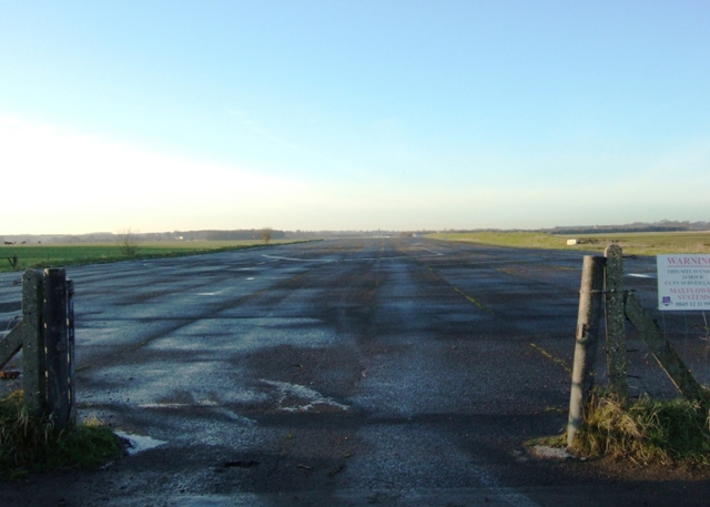
English: Former main runway at RAF Seighford Seighford Airfield was built on 450 acres of requisitioned farmland in 1941. It became operational in September 1942 as home to 30 Operational Training Unit RAF which, initially at least, flew Wellington bombers. The airfield became non-operational in 1947 and was taken over in 1956 by Boulton and Paul who used it as a test site until 1965 for a range of famous aircraft marques including the Viscount and the Lightning.
The main runway was 450 yards long and is still in existence, being currently used by a 'Driving Experience' company. |
| Date | |
| Source | From geograph.org.uk |
| Author | Simon Huguet |
| Attribution (required by the license) | Simon Huguet / Former main runway at RAF Seighford / |
| Camera location | | View this and other nearby images on: OpenStreetMap |
|---|
_heading:292.00&language=en)
| Object location | | View this and other nearby images on: OpenStreetMap |
|---|
_heading:292.00&language=en)
Licensing
[edit]

|
This image was taken from the Geograph project collection. See this photograph's page on the Geograph website for the photographer's contact details. The copyright on this image is owned by Simon Huguet and is licensed for reuse under the Creative Commons Attribution-ShareAlike 2.0 license.
|
This file is licensed under the Creative Commons Attribution-Share Alike 2.0 Generic license.
Attribution: Simon Huguet
- You are free:
- to share – to copy, distribute and transmit the work
- to remix – to adapt the work
- Under the following conditions:
- attribution – You must give appropriate credit, provide a link to the license, and indicate if changes were made. You may do so in any reasonable manner, but not in any way that suggests the licensor endorses you or your use.
- share alike – If you remix, transform, or build upon the material, you must distribute your contributions under the same or compatible license as the original.
File history
Click on a date/time to view the file as it appeared at that time.
| Date/Time | Thumbnail | Dimensions | User | Comment | |
|---|---|---|---|---|---|
| current | 04:05, 24 February 2011 | | 640 × 457 (160 KB) | GeographBot (talk | contribs) | == {{int:filedesc}} == {{Information |description={{en|1=Former main runway at RAF Seighford Seighford Airfield was built on 450 acres of requisitioned farmland in 1941. It became operational in September 1942 as home to 30 Operational Training Unit RAF w |
You cannot overwrite this file.
File usage on Commons
There are no pages that use this file.