File:Former quarry land off Ogden Lane and Toothill Bank, Rastrick - geograph.org.uk - 135619.jpg
Jump to navigation
Jump to search
No higher resolution available.
Former_quarry_land_off_Ogden_Lane_and_Toothill_Bank,_Rastrick_-_geograph.org.uk_-_135619.jpg (640 × 480 pixels, file size: 100 KB, MIME type: image/jpeg)
Captions
Captions
Add a one-line explanation of what this file represents
Summary
[edit]
| Description |
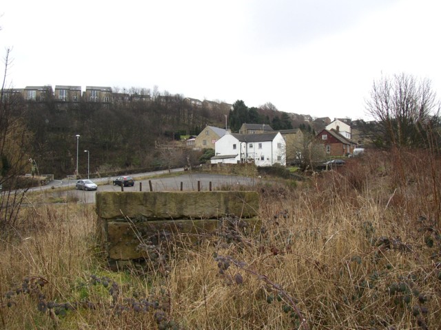
English: Former quarry land off Ogden Lane and Toothill Bank, Rastrick. This area is dotted with old mine shafts, apparently to mine a seam of good stone which presumably was too deep to get by open-cast methods. The structure in the foreground, with iron bars sticking out of a massive block of stone, might have been a crane, but this is a guess. The houses in the middle distance are on Toothill Bank, and those at the top of the hill on Long Ridge |
| Date | |
| Source | From geograph.org.uk |
| Author | Humphrey Bolton |
| Attribution (required by the license) | Humphrey Bolton / Former quarry land off Ogden Lane and Toothill Bank, Rastrick / |
| Camera location | | View this and other nearby images on: OpenStreetMap |
|---|
_heading:180.00&language=en)
| Object location | | View this and other nearby images on: OpenStreetMap |
|---|
_heading:180.00&language=en)
Licensing
[edit]

|
This image was taken from the Geograph project collection. See this photograph's page on the Geograph website for the photographer's contact details. The copyright on this image is owned by Humphrey Bolton and is licensed for reuse under the Creative Commons Attribution-ShareAlike 2.0 license.
|
This file is licensed under the Creative Commons Attribution-Share Alike 2.0 Generic license.
Attribution: Humphrey Bolton
- You are free:
- to share – to copy, distribute and transmit the work
- to remix – to adapt the work
- Under the following conditions:
- attribution – You must give appropriate credit, provide a link to the license, and indicate if changes were made. You may do so in any reasonable manner, but not in any way that suggests the licensor endorses you or your use.
- share alike – If you remix, transform, or build upon the material, you must distribute your contributions under the same or compatible license as the original.
File history
Click on a date/time to view the file as it appeared at that time.
| Date/Time | Thumbnail | Dimensions | User | Comment | |
|---|---|---|---|---|---|
| current | 04:16, 31 January 2010 | | 640 × 480 (100 KB) | GeographBot (talk | contribs) | == {{int:filedesc}} == {{Information |description={{en|1=Former quarry land off Ogden Lane and Toothill Bank, Rastrick. This area is dotted with old mine shafts, apparently to mine a seam of good stone which presumably was too deep to get by open-cast met |
You cannot overwrite this file.
File usage on Commons
There are no pages that use this file.