File:Formigas 1849 map.png
Jump to navigation
Jump to search

Size of this preview: 372 × 599 pixels. Other resolutions: 149 × 240 pixels | 298 × 480 pixels | 1,007 × 1,622 pixels.
Original file (1,007 × 1,622 pixels, file size: 4.68 MB, MIME type: image/png)
Captions
Captions
Add a one-line explanation of what this file represents
Summary
[edit]
| Description |
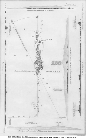
English: map of Formigas Islets, Azores, Atlantic Ocean (belong to Portugal) |
| Date | |
| Source | https://www.jstor.org/stable/1798091 |
| Author | Alex Vidal |
Licensing
[edit]
|
This work is in the public domain in its country of origin and other countries and areas where the copyright term is the author's life plus 100 years or fewer. | |
| This file has been identified as being free of known restrictions under copyright law, including all related and neighboring rights. | |
File history
Click on a date/time to view the file as it appeared at that time.
| Date/Time | Thumbnail | Dimensions | User | Comment | |
|---|---|---|---|---|---|
| current | 15:24, 6 October 2012 | | 1,007 × 1,622 (4.68 MB) | Ratzer (talk | contribs) | {{Information |Description ={{en|1=map of Formigas Islets, Azores, Atlantic Ocean (belong to Portugal)}} |Source =http://www.jstor.org/stable/1798091 (costs $$) |Author =Alex Vidal |Date =1849 |Permission = |other_versi... |
You cannot overwrite this file.
File usage on Commons
There are no pages that use this file.
File usage on other wikis
The following other wikis use this file:
- Usage on ca.wikipedia.org
- Usage on cs.wikipedia.org
- Usage on de.wikipedia.org
- Usage on en.wikipedia.org
- Usage on es.wikipedia.org
- Usage on fr.wikipedia.org
- Usage on it.wikipedia.org
- Usage on pt.wikipedia.org
- Usage on sk.wikipedia.org