File:France cities.png
跳至導覽
跳至搜尋

預覽大小:600 × 600 像素。 其他解析度:240 × 240 像素 | 480 × 480 像素 | 768 × 768 像素 | 1,025 × 1,024 像素 | 1,797 × 1,796 像素。
原始檔案 (1,797 × 1,796 像素,檔案大小:3.53 MB,MIME 類型:image/png)
說明
說明
添加單行說明來描述出檔案所代表的內容
| 描述 |
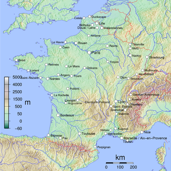
English: Map of Metropolitan French cities (agglomerations > 100,000 inhabitants on 1999 census).
Français : Carte des villes de la France métropolitaine (agglomérations de plus 100 000 habitants au recensement de 1999). See Image:France cities.pdf. |
||||||||
| 日期 | |||||||||
| 來源 | 自己的作品 | ||||||||
| 作者 | David Monniaux | ||||||||
| 授權許可 (重用此檔案) |
此檔案採用共享創意 姓名標示-相同方式分享 2.0 通用版授權條款。
此檔案採用創用CC 姓名標示-相同方式分享 2.0 法國授權條款。
 |
||||||||
| 其他版本 |
|

This image was selected as picture of the day on Wikimedia Commons for 6 April 2006. It was captioned as follows: Other languages:
Čeština: Mapa ukazující polohu velkých francouzských měst (nad 100 000 obyvatel). Deutsch: Karte der französischen Großstädte Français : Carte des villes de France métropolitaine de plus de 100 000 habitants Galego: Mapa de Francia Italiano: Carta delle città francesi con più di 100.000 abitanti Magyar: 100000-nél több lakosú francia nagyvárosok térképe Norsk nynorsk: Kart over Frankrike, der byar med over 100 000 innbyggjarar er merkte av. Polski: Największe miasta Francji (powyżej 100.000 mieszkańców) Português: Mapa da França Svenska: Frankrike-karta där städer med över 100 000 invånare är utsatta. Русский: Крупнейшие города Франции ไทย: แผนที่แสดงนครในประเทศฝรั่งเศสส่วนกลาง (la France métropolitaine) 日本語: フランスの主要都市を記した地図 中文: 法国十万人以上城市位置图 |
檔案歷史
點選日期/時間以檢視該時間的檔案版本。
| 日期/時間 | 縮圖 | 尺寸 | 用戶 | 備註 | |
|---|---|---|---|---|---|
| 目前 | 2007年4月17日 (二) 10:30 | | 1,797 × 1,796(3.53 MB) | Tene~commonswiki(對話 | 貢獻) | Optimised (5) |
| 2006年4月7日 (五) 19:26 |  | 1,797 × 1,796(3.64 MB) | Verdy p(對話 | 貢獻) | Edit the previous image to remove the uncentered white borders. | |
| 2005年6月1日 (三) 07:09 |  | 2,000 × 1,796(3.69 MB) | David.Monniaux(對話 | 貢獻) | ||
| 2005年5月28日 (六) 00:02 |  | 1,799 × 1,796(3.64 MB) | David.Monniaux(對話 | 貢獻) | bugfix | |
| 2005年5月27日 (五) 22:19 |  | 1,799 × 1,796(3.64 MB) | David.Monniaux(對話 | 貢獻) | debug | |
| 2005年5月27日 (五) 20:49 |  | 1,799 × 1,796(3.64 MB) | David.Monniaux(對話 | 貢獻) | fix bug | |
| 2005年5月27日 (五) 17:39 |  | 1,800 × 1,794(4.14 MB) | David.Monniaux(對話 | 貢獻) | Map of French cities {{subst:DMonniaux}} | |
| 2005年5月27日 (五) 17:34 |  | 2,000 × 1,796(4.18 MB) | David.Monniaux(對話 | 貢獻) | Map of French cities {{subst:DMonniaux}} |
無法覆蓋此檔案。
檔案用途
下列39個頁面有用到此檔案:
- Atlas of France
- France
- User:David.Monniaux
- User:Hatonjan
- User:Prismo345
- User:Prismo345/Imágenes
- User:Wikisoft*/Cartes
- Commons:Featured picture candidates/Image:France cities.png
- Commons:Featured picture candidates/Log/July 2020
- Commons:Featured picture candidates/Log/November 2005
- Commons:Featured picture candidates/removal/File:France cities.png
- Commons:Featured pictures/chronological/2005-B
- Commons:Potd/2006-04 (fr)
- Commons:Potd/2006-04 (pl)
- Commons:Potd/2006-04 (pt)
- Commons:Potd/2006-04 (tr)
- Commons talk:Featured picture candidates/Archive candidate list
- File:France cities.pdf
- File:Temps de parcours voiture depuis Brest.tif
- Template:Potd/2006-04
- Template:Potd/2006-04-06
- Template:Potd/2006-04-06 (cs)
- Template:Potd/2006-04-06 (de)
- Template:Potd/2006-04-06 (en)
- Template:Potd/2006-04-06 (es)
- Template:Potd/2006-04-06 (fr)
- Template:Potd/2006-04-06 (gl)
- Template:Potd/2006-04-06 (hu)
- Template:Potd/2006-04-06 (it)
- Template:Potd/2006-04-06 (ja)
- Template:Potd/2006-04-06 (nl)
- Template:Potd/2006-04-06 (nn)
- Template:Potd/2006-04-06 (pl)
- Template:Potd/2006-04-06 (pt)
- Template:Potd/2006-04-06 (ru)
- Template:Potd/2006-04-06 (sv)
- Template:Potd/2006-04-06 (th)
- Template:Potd/2006-04-06 (zh-hans)
- Category:Geography of France
全域檔案使用狀況
以下其他 wiki 使用了這個檔案:
- af.wikipedia.org 的使用狀況
- als.wikipedia.org 的使用狀況
- ar.wikipedia.org 的使用狀況
- as.wikipedia.org 的使用狀況
- az.wikipedia.org 的使用狀況
- bg.wikipedia.org 的使用狀況
- br.wikipedia.org 的使用狀況
- ceb.wikipedia.org 的使用狀況
- co.wikipedia.org 的使用狀況
- cs.wikipedia.org 的使用狀況
- cy.wikipedia.org 的使用狀況
- da.wikipedia.org 的使用狀況
- de.wikipedia.org 的使用狀況
- el.wikipedia.org 的使用狀況
- en.wikipedia.org 的使用狀況
- eo.wikipedia.org 的使用狀況
- es.wikivoyage.org 的使用狀況
- eu.wikipedia.org 的使用狀況
- fa.wikipedia.org 的使用狀況
- fi.wikipedia.org 的使用狀況
- frp.wikipedia.org 的使用狀況
- fr.wikipedia.org 的使用狀況
- Wikipédia:Image du jour/6 avril 2006
- Wikipédia:Image du jour/avril 2006
- Utilisateur:Wikisoft*/Cartes
- Utilisateur:Wikisoft*/Géobox
- Utilisateur:Wikisoft*/Tests cartes 1
- Utilisateur:Wikisoft*/Modèle:Infobox Montagnes de France
- Discussion utilisateur:Wikisoft*/Modèle:Infobox Montagnes de France
- Utilisateur:Géobox/5
- Discussion utilisateur:TomKr/Cartographie
- Projet:Cartographie/Cartes standards/Pays
- Discussion utilisateur:Sting/Archive 08
- Utilisateur:Géobox/Géolocalisation/France
檢視此檔案的更多全域使用狀況。