File:French Polynesia relief map with communes.svg

原本檔案 (SVG檔案,表面大細: 1,260 × 1,260 像素,檔案大細:1.52 MB)
Captions
Captions
摘要[編輯]
| 描述 |
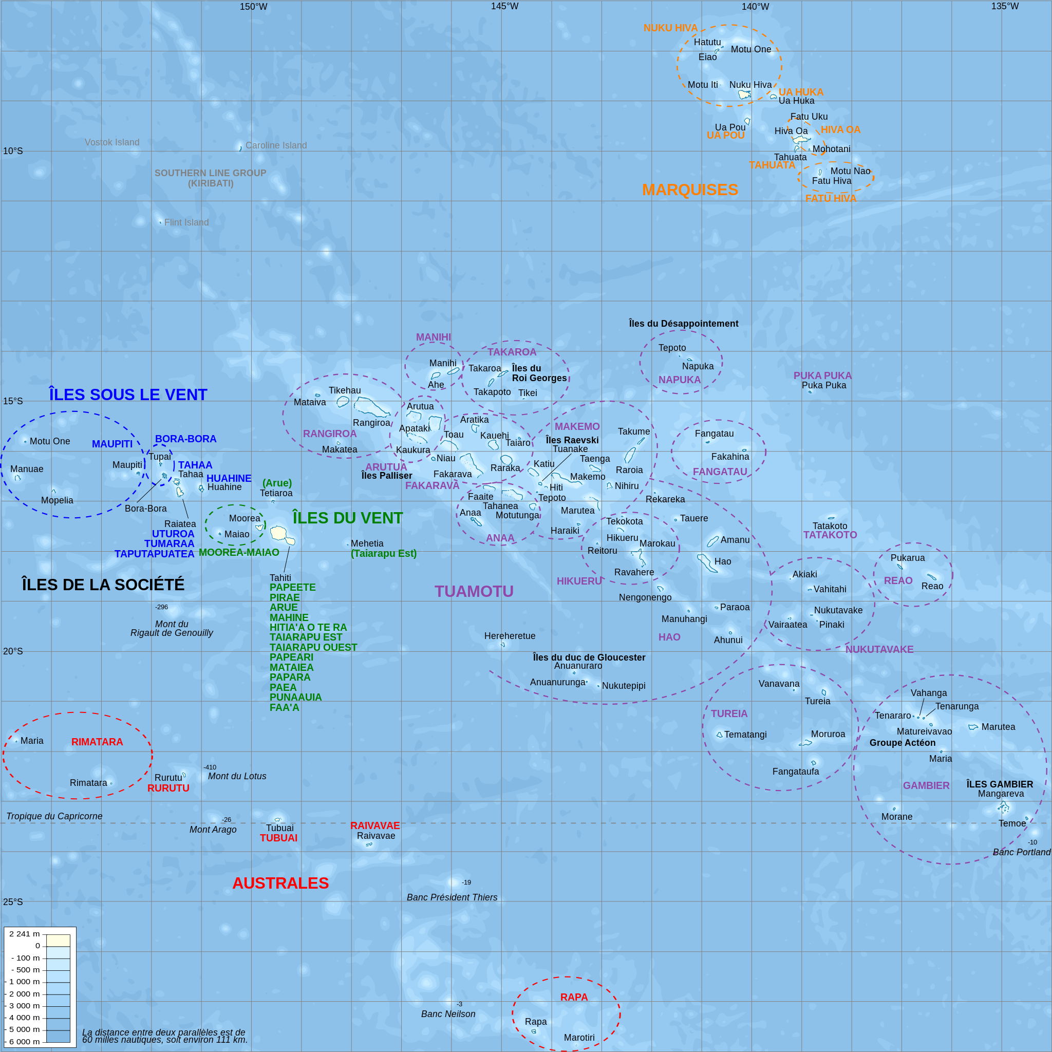
Català: Mapa topogràfic amb noms de subdivisions de la Polinèsia Francesa (en francès)
English: Topographic map with subdivision names of French Polynesia (in French)
Français : Carte topographique de la Polynésie française, en français, avec les noms des subdivisions (communes et archipels) |
| 日期 | |
| 來源 |
Own work.
Data sources :
Softwares used :
Others :
|
| 作者 | L. Claudel (Sardon - fr:Sardon) |
| Other versions |
Other related versions: []
|


|
This SVG file contains embedded text that can be translated into your language, using any capable SVG editor, text editor or the SVG Translate tool. For more information see: About translating SVG files. |
This file is translated using SVG <switch> elements. All translations are stored in the same file! Learn more.
For most Wikipedia projects, you can embed the file normally (without a To translate the text into your language, you can use the SVG Translate tool. Alternatively, you can download the file to your computer, add your translations using whatever software you're familiar with, and re-upload it with the same name. You will find help in Graphics Lab if you're not sure how to do this. |
協議[編輯]

|
根據自由軟體基金會發佈嘅無固定段落、封面文字同封底文字GNU自由文件授權條款第1.2或打後嘅版本,你獲授權可以重製、散佈同埋修改爾份文件。授權條款嘅副本喺章節GNU自由文件授權條款。 |
- 你可以:
- 去分享 – 複製、發佈同傳播呢個作品
- 再改 – 創作演繹作品
- 要遵照下面嘅條件:
- 署名 – 你一定要畀合適嘅表彰、畀返指向呢個授權條款嘅連結,同埋寫明有無改過嚟。你可以用任何合理方式去做,但唔可以用任何方式暗示授權人認可咗你或者你嘅使用方式。
- 相同方式分享 – 如果你用任何方式改過呢個作品,你必須要用返原本或者相似嘅條款發佈。
檔案歷史
撳個日期/時間去睇響嗰個時間出現過嘅檔案。
| 日期/時間 | 縮圖 | 尺寸 | 用戶 | 註解 | |
|---|---|---|---|---|---|
| 現時 | 2024年2月15號 (四) 21:39 | | 1,260 × 1,260(1.52 MB) | Manlleus(傾偈 | 貢獻) | File uploaded using svgtranslate tool (https://svgtranslate.toolforge.org/). Added translation for ca. |
| 2008年10月16號 (四) 20:32 |  | 1,260 × 1,260(1.4 MB) | Sardon(傾偈 | 貢獻) | {{Information |Description={{en|1=Topographic map with subdivision names of French Polynesia (in French)}} {{fr|1=Carte topographique de la Polynésie française, en français, avec les noms des subdivisions (communes et archipels)}} |Source=Own work.{{cl |
你無得衾咗個檔案。
檔案用途
以下嘅11版用到呢個檔:
- Atlas of French Polynesia
- User:Esby/lilyu
- User:Esby/lilyu2
- User:Magog the Ogre/Multilingual legend/2024 February 15-19
- User talk:Lilyu
- File:French Polynesia relief map.svg
- File:French Polynesia relief map BG.svg
- File:French Polynesia relief map RU.svg
- File:French Polynesia relief map with communes-mk.svg
- File:French Polynesia relief map with communes.svg
- Template:Other versions/French Polynesia relief map with communes
全域檔案使用情況
下面嘅維基都用緊呢個檔案:
- af.wikipedia.org嘅使用情況
- als.wikipedia.org嘅使用情況
- ar.wikipedia.org嘅使用情況
- ca.wikipedia.org嘅使用情況
- cs.wikipedia.org嘅使用情況
- de.wikipedia.org嘅使用情況
- de.wikivoyage.org嘅使用情況
- el.wikipedia.org嘅使用情況
- en.wikipedia.org嘅使用情況
- en.wiktionary.org嘅使用情況
- eo.wikipedia.org嘅使用情況
睇呢個檔案嘅更多全域使用情況。