File:Gap in Right of Way beside Christmas Hill - geograph.org.uk - 934688.jpg
Jump to navigation
Jump to search
No higher resolution available.
Gap_in_Right_of_Way_beside_Christmas_Hill_-_geograph.org.uk_-_934688.jpg (640 × 427 pixels, file size: 135 KB, MIME type: image/jpeg)
Captions
Captions
Add a one-line explanation of what this file represents
Summary[edit]
| Description |
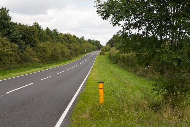
English: Gap in Right of Way beside Christmas Hill. A restricted byway runs left from this yellow post, see 934678. A further restricted byway runs rightwards from the crest of the hill to South Wonston Farm. This stretch of land beside the road joins the two but is not a Right of Way, or so it appears on Hampshire County Council maps. It seems likely that the byway in the distance originally ran diagonally across this road but that it was cut off by the making of the A34(T) which runs parallel to this road to the left of the trees. |
| Date | |
| Source | From geograph.org.uk |
| Author | Peter Facey |
| Attribution (required by the license) | Peter Facey / Gap in Right of Way beside Christmas Hill / |
_-_geograph.org.uk_-_934678.jpg)
| Camera location | | View this and other nearby images on: OpenStreetMap |
|---|
_heading:0.00&language=en)
| Object location | | View this and other nearby images on: OpenStreetMap |
|---|
_heading:0.00&language=en)
Licensing[edit]

|
This image was taken from the Geograph project collection. See this photograph's page on the Geograph website for the photographer's contact details. The copyright on this image is owned by Peter Facey and is licensed for reuse under the Creative Commons Attribution-ShareAlike 2.0 license.
|
This file is licensed under the Creative Commons Attribution-Share Alike 2.0 Generic license.
Attribution: Peter Facey
- You are free:
- to share – to copy, distribute and transmit the work
- to remix – to adapt the work
- Under the following conditions:
- attribution – You must give appropriate credit, provide a link to the license, and indicate if changes were made. You may do so in any reasonable manner, but not in any way that suggests the licensor endorses you or your use.
- share alike – If you remix, transform, or build upon the material, you must distribute your contributions under the same or compatible license as the original.
File history
Click on a date/time to view the file as it appeared at that time.
| Date/Time | Thumbnail | Dimensions | User | Comment | |
|---|---|---|---|---|---|
| current | 06:33, 22 February 2011 | | 640 × 427 (135 KB) | GeographBot (talk | contribs) | == {{int:filedesc}} == {{Information |description={{en|1=Gap in Right of Way beside Christmas Hill A restricted byway runs left from this yellow post, see 934678. A further restricted byway runs rightwards from the crest of the hill to South Wonston F |
You cannot overwrite this file.
File usage on Commons
There are no pages that use this file.