File:George Street, Kingston upon Hull (geograph 6548226).jpg
Jump to navigation
Jump to search

Size of this preview: 799 × 599 pixels. Other resolutions: 320 × 240 pixels | 640 × 480 pixels | 1,024 × 768 pixels | 1,280 × 960 pixels | 2,441 × 1,831 pixels.
Original file (2,441 × 1,831 pixels, file size: 1.03 MB, MIME type: image/jpeg)
Captions
Captions
Add a one-line explanation of what this file represents
Summary[edit]
.jpg&action=edit§ion=1)
| Description |
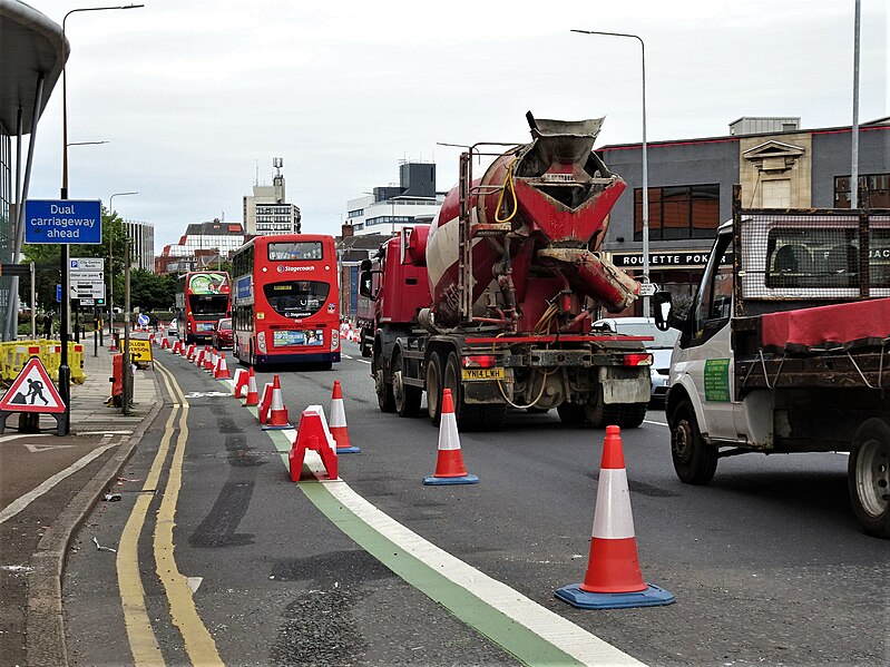
English: The City Council has secured funding to undertake works to keep cyclists safe and encourage more active travel. Here, an existing cycle lane between North Bridge and Wilberforce Drive has been partially re-routed, and coned-off to prevent access by other traffic. Further reading in Hull CC News: Link and the Hull Daily Mail: Link |
| Date | |
| Source | From geograph.org.uk |
| Author | Bernard Sharp |
| Permission (Reusing this file) |
Creative Commons Attribution Share-alike license 2.0 |
| Attribution (required by the license) | Bernard Sharp / George Street, Kingston upon Hull / |
| Camera location | | View this and other nearby images on: OpenStreetMap |
|---|
.jpg¶ms=053.747534_N_-000.330533_E_globe:Earth_type:camera_source:geograph-osgb36(TA10192920)_heading:270.00&language=en)
| Object location | | View this and other nearby images on: OpenStreetMap |
|---|
.jpg¶ms=053.747540_N_-000.330680_E_globe:Earth_class:object_type:object_source:geograph-osgb36(TA10182920)_heading:270.00&language=en)
Licensing[edit]
.jpg&action=edit§ion=2)

|
This image was taken from the Geograph project collection. See this photograph's page on the Geograph website for the photographer's contact details. The copyright on this image is owned by Bernard Sharp and is licensed for reuse under the Creative Commons Attribution-ShareAlike 2.0 license.
|
This file is licensed under the Creative Commons Attribution-Share Alike 2.0 Generic license.
Attribution: Bernard Sharp
- You are free:
- to share – to copy, distribute and transmit the work
- to remix – to adapt the work
- Under the following conditions:
- attribution – You must give appropriate credit, provide a link to the license, and indicate if changes were made. You may do so in any reasonable manner, but not in any way that suggests the licensor endorses you or your use.
- share alike – If you remix, transform, or build upon the material, you must distribute your contributions under the same or compatible license as the original.
File history
Click on a date/time to view the file as it appeared at that time.
| Date/Time | Thumbnail | Dimensions | User | Comment | |
|---|---|---|---|---|---|
| current | 09:20, 23 August 2023 | | 2,441 × 1,831 (1.03 MB) | Hullian111-Flickr2Commons (talk | contribs) | == {{int:filedesc}} == {{Information |Description={{en|1=The City Council has secured funding to undertake works to keep cyclists safe and encourage more active travel. Here, an existing cycle lane between North Bridge and Wilberforce Drive has been partially re-routed, and coned-off to prevent access by other traffic. Further reading in Hull CC News: [https://www.hullccnews.co.uk/24/07/2020/safer-cycling-in-hull/ Link] and the Hull Daily Mail: [https://www.hulldailymail.co.uk/news/hull-east-... |
You cannot overwrite this file.
File usage on Commons
There are no pages that use this file.
Metadata
.jpg&oldid=853167230)
Categories:
- Files with coordinates missing SDC location of creation (53° N, -1°E)
- George Street, Kingston upon Hull
- Roadworks in Kingston upon Hull
- Cycling infrastructure in England
- Cycling in the East Riding of Yorkshire
- Automobiles in Kingston upon Hull
- Buses in Kingston upon Hull
- Stagecoach in Hull
- Stagecoach buses in Beachball livery in the United Kingdom
- 2 buses in the United Kingdom
- July 2020 in Kingston upon Hull