File:Germany, Federal Republic of location map January 1957 - October 1990.svg

Originaldatei (SVG-Datei, Basisgröße: 1.075 × 1.273 Pixel, Dateigröße: 490 KB)
Bildtexte
Kurzbeschreibungen
Beschreibung[Bearbeiten]
| Beschreibung |
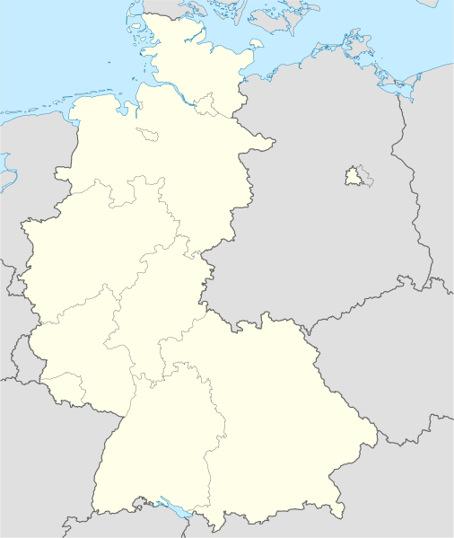
Deutsch: Positionskarte der Bundesrepublik Deutschland. Diese Karte zeigt die Bundesrepublik im Gebietsstand zwischen Januar 1957 bis Oktober 1990.
Quadratische Plattkarte, N-S-Streckung 150 %. Geographische Begrenzung der Karte:
English: Location map of Federal Republic of Germany. Map shows West-Germany as of January 1957 till October 1990.
Equirectangular projection, N/S stretching 150 %. Geographic limits of the map:
|
||
| Datum | Created in 2009 | ||
| Quelle | own work, based on File:Germany location map.svg | ||
| Urheber | TUBS | ||
| Genehmigung (Weiternutzung dieser Datei) |
Ich, der Urheberrechtsinhaber dieses Werkes, veröffentliche es hiermit unter der folgenden Lizenz:
Diese Datei ist unter der Creative-Commons-Lizenz „Namensnennung – Weitergabe unter gleichen Bedingungen 3.0 nicht portiert“ lizenziert.
Du darfst es unter einer der obigen Lizenzen deiner Wahl verwenden. |
||
| Andere Versionen |
Abgeleitete Werke dieser Datei: Bundesrepublik Deutschland (vor 1990 nur West-Deutschland):
Deutsche Demokratische Republik (mit BRD im Ausschnitt):
Ostdeutschland (vor 1990 Deutsche Demokratische Republik):
Deutschland zwischen Mai 1945 und Oktober 1949:
Thematisch:
Deutsches Reich (1918–1945) (best used with this template (de)):
|


_23_May_1949_-_6_Oct_1949.svg)


_location_map.svg)
_location_map_2013.svg)


.svg&action=edit&redlink=1)
.svg)
Dateiversionen
Klicke auf einen Zeitpunkt, um diese Version zu laden.
| Version vom | Vorschaubild | Maße | Benutzer | Kommentar | |
|---|---|---|---|---|---|
| aktuell | 14:53, 16. Sep. 2013 | | 1.075 × 1.273 (490 KB) | NordNordWest (Diskussion | Beiträge) | Reverted to version as of 08:36, 16 September 2013; your are destroying the location map function of this map |
| 12:46, 16. Sep. 2013 |  | 927 × 1.274 (673 KB) | SokoWiki (Diskussion | Beiträge) | Berlin was not part of the Federal Republic of Germany until 1990. | |
| 08:36, 16. Sep. 2013 |  | 1.075 × 1.273 (490 KB) | NordNordWest (Diskussion | Beiträge) | Reverted to version as of 22:14, 15 September 2013 | |
| 22:39, 15. Sep. 2013 |  | 927 × 1.274 (673 KB) | SokoWiki (Diskussion | Beiträge) | Reverted to version as of 20:04, 15 September 2013 | |
| 22:14, 15. Sep. 2013 |  | 1.075 × 1.273 (490 KB) | TUBS (Diskussion | Beiträge) | Reverted to version as of 03:25, 18 January 2009 | |
| 20:04, 15. Sep. 2013 |  | 927 × 1.274 (673 KB) | SokoWiki (Diskussion | Beiträge) | * | |
| 03:25, 18. Jan. 2009 |  | 1.075 × 1.273 (490 KB) | TUBS (Diskussion | Beiträge) | {{Information |Description=Germany,_Federal_Republic_of__location_map_April_1952_-_August_1955 |Source=own work |Date=2009 |Author=Author:TUBS |Permission= |other_versions= }} <!--{{ImageUpload|basic}}--> |
Du kannst diese Datei nicht überschreiben.
Dateiverwendung
Die folgenden 90 Seiten verwenden diese Datei:
- File:Deutschland Autobahnen.svg
- File:East-West-Germany-October 1949-July 1952.svg
- File:East Germany location map.svg
- File:Germany, Federal Republic of location map 23 May 1949 - 6 Oct 1949.svg
- File:Germany, Federal Republic of location map April 1952 - August 1955.svg
- File:Germany, Federal Republic of location map December 1950 - April 1952.svg
- File:Germany, Federal Republic of location map January 1957 - October 1990.svg
- File:Germany, Federal Republic of location map October 1949 - November 1950.svg
- File:Germany, Federal Republic of location map September 1955 - December 1956.svg
- File:Germany, German Democratic Republic location map January 1957 - October 1990.svg
- File:Germany, German Democratic Republic location map July 1952 - January 1957.svg
- File:Germany, German Democratic Republic location map October 1949 - July 1952.svg
- File:Germany, German Democratic Republic location map w·o FRG July 1952 - October 1990.svg
- File:Germany, German Democratic Republic location map w·o FRG October 1949 - June 1952.svg
- File:Germany, location map (SBZ perspective) 23 May 1949 - 6 Oct 1949.svg
- File:Germany2 location map.svg
- File:Germany location map.svg
- File:Germany location map 23 April 1949 - 22 May 1949.svg
- File:Germany location map 8 Jun 1947 - 22 Apr 1949.svg
- File:Germany location map April 1992 - July 1992.svg
- File:Germany location map August 1992 - June 1993.svg
- File:Germany location map July 1993 - December 2009.svg
- File:Germany location map October 1990 - March 1992.svg
- File:Germany location map labeled 8 Jun 1947 - 22 Apr 1949.svg
- File:Lage Freiberg in Deutschland.png
- File:MPR-coverage in cold war Germany.svg
- File:MissionsMilitairesDeLiaisonSovietique.svg
- File:Relief Map of Germany.png
- File:Relief Map of Germany.svg
- File:Restricted Zones SOXMIS.svg
- Template:Germany location map/other versions
- Category:1949 in West Germany
- Category:1950 in West Germany
- Category:1951 in West Germany
- Category:1952 in West Germany
- Category:1953 in West Germany
- Category:1954 in West Germany
- Category:1955 in West Germany
- Category:1956 in West Germany
- Category:1957 in West Germany
- Category:1958 in West Germany
- Category:1960 in West Germany
- Category:1961 in West Germany
- Category:1962 in West Germany
- Category:1963 in West Germany
- Category:1964 in West Germany
- Category:1965 in West Germany
- Category:1966 in West Germany
- Category:1967 in West Germany
- Category:1968 in West Germany
- Category:1969 in West Germany
- Category:1970 in West Germany
- Category:1971 in West Germany
- Category:1972 in West Germany
- Category:1973 in West Germany
- Category:1974 in West Germany
- Category:1975 in West Germany
- Category:1976 in West Germany
- Category:1977 in West Germany
- Category:1978 in West Germany
- Category:1979 in West Germany
- Category:1980 in West Germany
- Category:1981 in West Germany
- Category:1982 in West Germany
- Category:1983 in West Germany
- Category:1984 in West Germany
- Category:1985 in West Germany
- Category:1986 in West Germany
- Category:1987 in West Germany
- Category:1988 in West Germany
- Category:1989 in West Germany
- Category:1990 in West Germany
- Category:Athletics competitors from West Germany
- Category:Bilateral relations of West Germany
- Category:Events in West Germany
- Category:Figure skating in West Germany
- Category:Geography of West Germany
- Category:History of West Germany
- Category:Maps of West Germany
- Category:Men of West Germany
- Category:Olympic figure skaters from West Germany
- Category:West Germany
- Category:West Germany by decade
- Category:West Germany by year
- Category:West Germany in the 1950s
- Category:West Germany in the 1960s
- Category:West Germany in the 1970s
- Category:West Germany in the 1980s
- Category:West Germany in the 1990s
- Category:Women of West Germany
Globale Dateiverwendung
Die nachfolgenden anderen Wikis verwenden diese Datei:
- Verwendung auf af.wikipedia.org
- Verwendung auf als.wikipedia.org
- Verwendung auf ar.wikipedia.org
- Verwendung auf az.wikipedia.org
- Verwendung auf ban.wikipedia.org
- Verwendung auf bn.wikipedia.org
- ১৯৬৩–৬৪ বুন্দেসলিগা
- ১৯৬৪–৬৫ বুন্দেসলিগা
- ১৯৬৫–৬৬ বুন্দেসলিগা
- ১৯৬৬–৬৭ বুন্দেসলিগা
- ১৯৬৭–৬৮ বুন্দেসলিগা
- ১৯৬৮–৬৯ বুন্দেসলিগা
- ১৯৬৯–৭০ বুন্দেসলিগা
- ১৯৭০–৭১ বুন্দেসলিগা
- ১৯৭১–৭২ বুন্দেসলিগা
- ১৯৭২–৭৩ বুন্দেসলিগা
- ১৯৭৩–৭৪ বুন্দেসলিগা
- ১৯৭৪–৭৫ বুন্দেসলিগা
- ১৯৭৫–৭৬ বুন্দেসলিগা
- ১৯৭৬–৭৭ বুন্দেসলিগা
- ১৯৭৭–৭৮ বুন্দেসলিগা
- ১৯৭৮–৭৯ বুন্দেসলিগা
- ১৯৭৯–৮০ বুন্দেসলিগা
- ১৯৮০–৮১ বুন্দেসলিগা
- ১৯৮১–৮২ বুন্দেসলিগা
- ১৯৮২–৮৩ বুন্দেসলিগা
- ১৯৮৩–৮৪ বুন্দেসলিগা
- ১৯৮৪–৮৫ বুন্দেসলিগা
- ১৯৮৫–৮৬ বুন্দেসলিগা
- ১৯৮৬–৮৭ বুন্দেসলিগা
- ১৯৮৭–৮৮ বুন্দেসলিগা
- ১৯৮৮–৮৯ বুন্দেসলিগা
- ১৯৮৯–৯০ বুন্দেসলিগা
- ১৯৯০–৯১ বুন্দেসলিগা
Weitere globale Verwendungen dieser Datei anschauen.